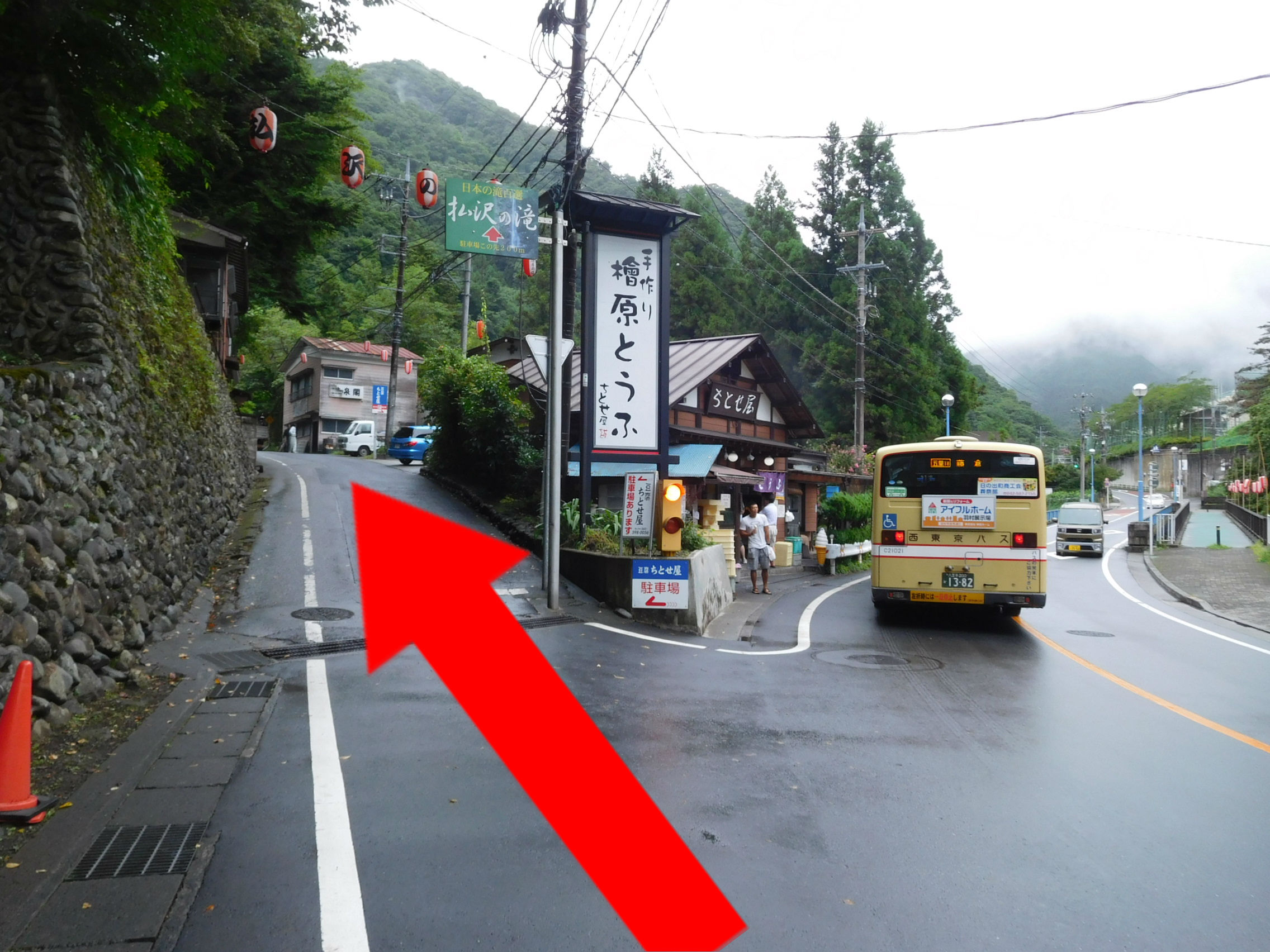
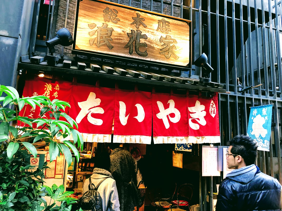
From Itsukaichi (五日市) direction enter Hinohara village and turn right at the first traffic light (Tachibana bridge, 橘橋). Turn left at the side of Tofu shop (Chitose-ya, ちとせ屋), and proceed along the street a little narrower you will see a parking lot paved on your right hand side. (Fee is free: 30 normal vehicles, 3 large buses).
A little farther on, there are a parking lot.
* If you use car navigation system please set the following information.
Hinohara Tofu Chitoseya (Hinohara Tofu Chitosea)
TEL: 042-598-0056
Address: 5557 Hinohara village Nishitama-gun, Tokyo (東京都西多摩郡檜原村 5557), click here for google map.
Google Map of Hinohara Tofu Chitoseya (Hinohara Tofu Chitosea)
In Case of Using Train and Bus
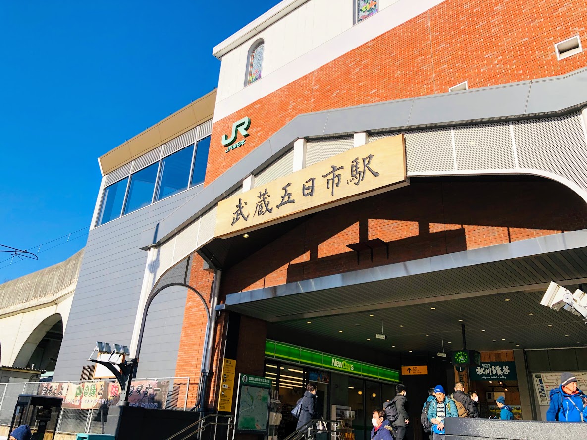
From JR Shinjuku (新宿) station to Musashi-Itsukaichi (武蔵五日市) station
The best way is by holiday rapid train (holiday kaisoku, ホリデー快速) from JR Shinjuku station to Musashi-Itsukaichi (武蔵五日市). Unfortunately, there are only a few of those on limited holydays and weekends, which leave from platform 11 and take 1 hour and 10 minutes. Note that only the front half of train completes the entire journey to Musashi-Itsukaichi Station, the remaining carriages going to Okutama (奥多摩).
Alternatively, from Platform 12 station on the same station, catch a more frequent rapid service train (快速) or special service train (特別快速) to Tachikawa (立川) Station on the Chūō Line. Those take 38 and 27 minutes, respectively. At the Tachikawa, change to Platform 1/2, which is the JR Ōme Line (青梅線). It will probably be necessary to change again at Haijima (拝島) Station for the last part of the journey to Musashi-Itsukaichi, the terminus of the Itsukaichi Line (五日市線). From Tachikawa to Musashi-Itsukaichi takes a total of 30-40 minutes, not including connection time. A single ticket from Shinjuku to Musashi-Isukaichi costs 799 JPY.
Please check the latest timetable, because the timetable and fare are sometimes changed.
Timetable and Route Serch “HyperDia” http://www.hyperdia.com/sp/index.html.en
Musashi-itsukaichi Station
From Musashi-Itsukaichi (武蔵五日市) Station to Hosawa Waterfall Entrance (払沢の滝入口) Bus Stop
Leave Musashi-Isukaichi Station by the only exit, turn left, there are some bus stops, and board a No. 1 platform (1バスのりば) bound for “Hosawa Waterfall Entrance” (払沢の滝入口) or “Fujikura” (藤倉) or “Via Hosawa Waterfall Entrance” (払沢の滝入口経由) or “Kazuma via Yasaragino-sato” (やすらぎの里経由 数馬). Get off at the Hosawa Waterfall Entrance (払沢の滝入口) after 20-25 minutes.
Note: The bus going are very few numbers.
Even if there is no convenient bus, you can bound for “Kazuma” (数馬).
But in those case, you have to get off at Honjuku-yakubamae (本宿役場前), and cross the bridge in the same direction as the bus was traveling. On reaching a T-junction at end of the bridge, turn right and some 5-10 minutes along this track, there are Hosawa Waterfall Entrance (払沢の滝入口) Bus Stop.
From Hosawa Waterfall Entrance (払沢の滝入口) Bus Stop to Hiking Route of Waterfall
A little farther on, there are a parking lot of Hosawa Waterfall.
Turn left at the side of Tofu shop (Chitose-ya, ちとせ屋) in front of bus stop, and proceed along the street a little narrower you will see a parking lot paved on your right hand side. Turn left in the direction marked “払沢の滝”, some 15-20 minutes along this trail, there is Hosawa Waterfall.
The hiking course of Sengen ridge (Sengen-one, 浅間尾根) offers beautiful mountain views and Hosawa waterfall. You can access to this trailhead for about 1 hours and a half from Shinjuku station. This trail was an important road from old times, called Koshu way (甲州道), which connects both countries of Bushu (武州) and Koshu (甲州), in the Edo period was a track for an important life for transporting charcoal. Let’s relax and enjoy hike while thinking of old time people in the clear air which hard to believe you’re still in Tokyo.
You can walk enjoying fine views of such nearby peaks as Mt.Gozen on your right side.
Area: Chichibu-Tama National Park, Hinohara village, Tokyo
Access: Musashi-Itsukaichi Station (武蔵五日市駅) on JR Itsukaichi Line, get off at Hosawa Waterfall Entrance (払沢の滝入口). For more information, click here
Start: Hosawa Waterfall Entrance Bus Stop (払沢の滝入口バス停)
Goal: Henbori Bus Stop (人里バス停)
Difficulty of this trail: ★ ☆ ☆ ☆ ☆
Trail appearance rate: ★ ★ ☆ ☆ ☆
Total distance: 8 km
Total difference in elevation: 661 m
Walking time: 3 hours and 30 minutes
Point of interest: Hosawa Waterfall (particularly in winter), wildflowers (spring to autumn), mountain views, japanese macaque (winter), an Edo-period track for transporting charcoal.
Access to Hosawa Waterfall Entrance (Hosawa-no-taki-Iriguchi, 払沢の滝入口)
Please refer to the following for detailed access method.
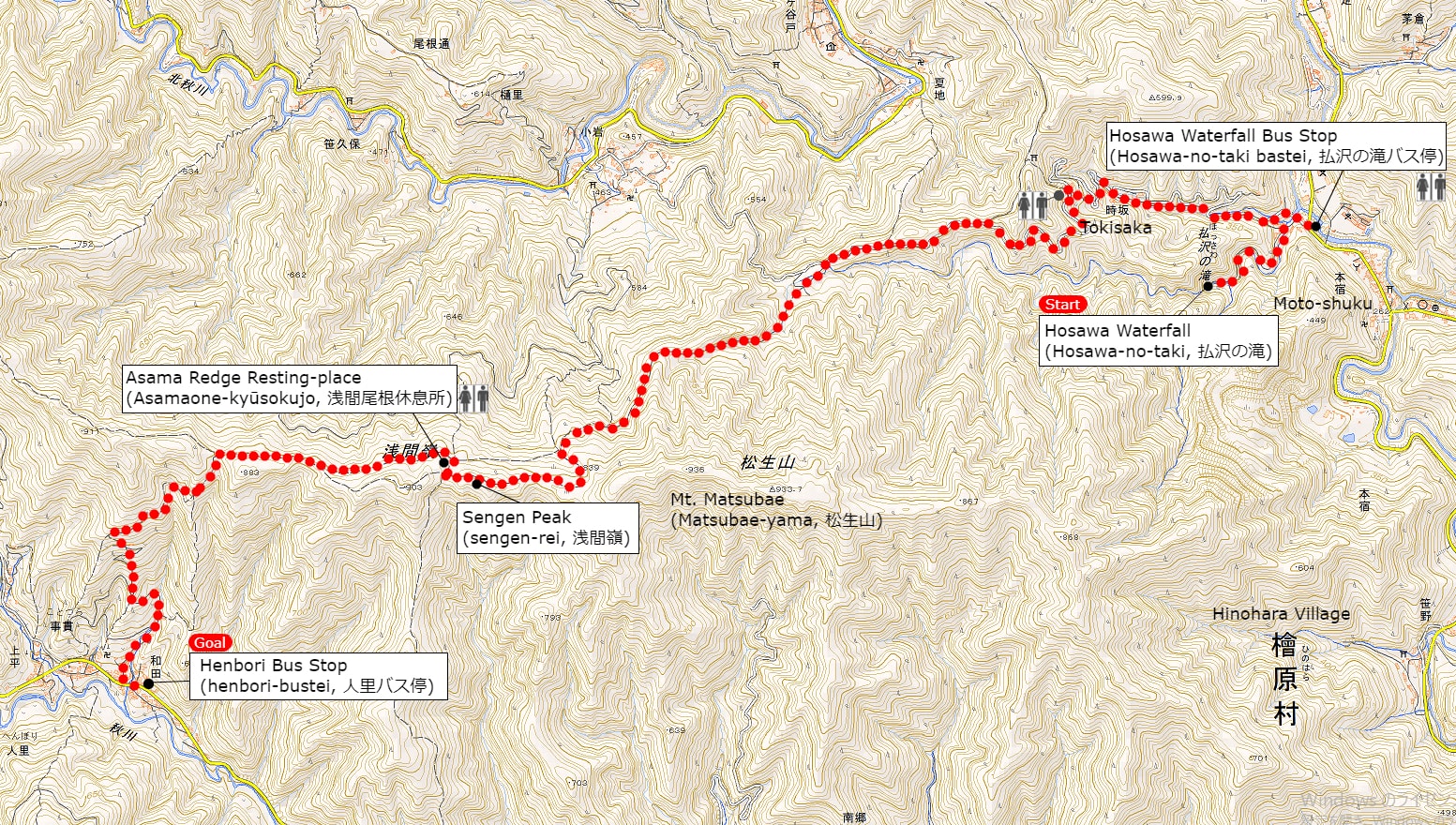
A Map of Sengen Ridge Hiking Route (include Hosawa Waterfall)
A Map of Sengen Ridge Hiking Course | Click on the image above to open the enlarged image in a separate tab.
The source of above the three maps are “Digital Japan Web System” of The Geospatial Information Authority of Japan. The maps were edited a author of this blog.
In Japanese: これらの3枚の地図は国土地理院の電子国土Webシステムから配信されたものをこのブログの著者が加工したものである。
From Hosawa Waterfall Entrance Bus Stop (払沢の滝入口バス停) to Sengen Peak (Sengen-rei, 浅間嶺)
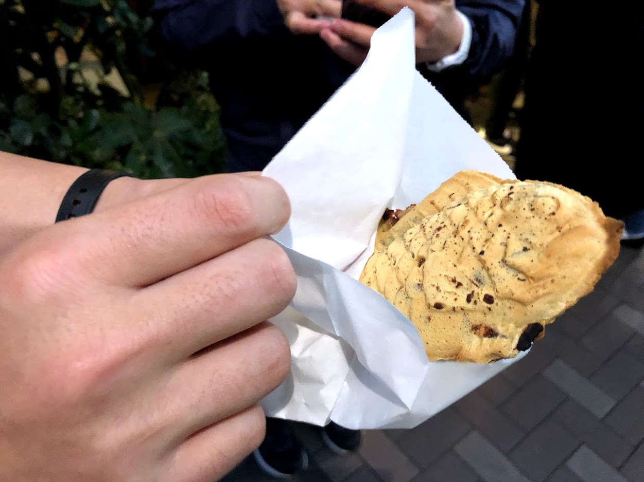
I also recommend popular menu fried donuts and soy milk, both of which are 100 yen at this tofu shop.
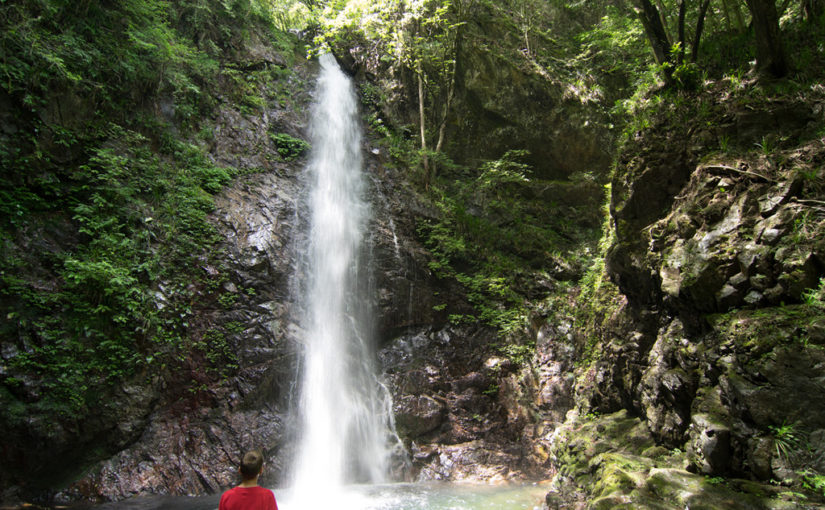
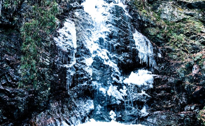
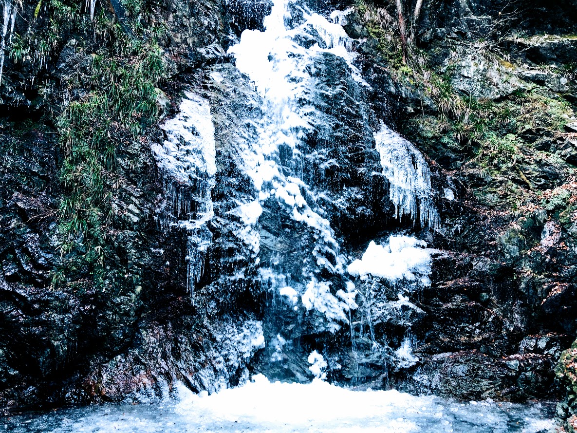
A sign above the road next to left side of the Tofu shop (檜原とうふ ちとせ屋) reads “Hosawa Waterfall” (Howasa no taki, 払沢の滝). Following this sign, go to the narrow road a little bit further on. To get to the waterfall, veer left at a fork a few minutes later onto a dirt path also marked for Hosawa waterfall, though with a simplified first character (払沢の滝). The waterfall is 5-10 minutes along this high rocky path, which crosses several small bridges. In winter, parts of the 60-meter fall and most of the pool at the bottom freeze over, and the icicles hanging off the face make for a splendid sight.
Hosawa Waterfall freezes from late January to early February. This photo above is February 2, 2019.
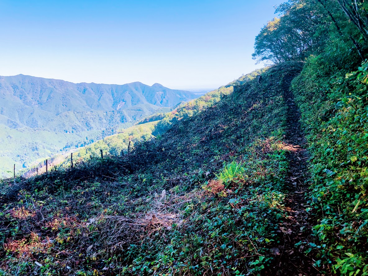
After visitting the waterfall, return to the previous junction, turn hard left in the direction of Sengen Ridge (Sengen-one, 浅間尾根). This path merges with a dirt road, which you follow uphill to the large bitumen road and bear left. The trail leaves and rejoins this road several times over the next kilometer or so, and passes many old wooden houses.
A few minutes further on, at the sign for “Zizaka Pass, Sengen Peak” (時坂峠 浅間嶺), take the steps up to the left. Rejoin the road 10 minutes later, again heading uphill to the left. The path (similarly signposted) resumes sharply to the left after about 10 more minutes. From here it zigzags up the hill, crossing the road (at a similar sign) after 5 minutes.
The Path soon bend left (near a tiny shrine), and begins to trace the line of Sengen Ridge, merging with the dirt road that enters from the left after 5-10 minutes.
This farmhouse has been built more than 400 years.
Walking for 7 minutes or so will bring you to a magnificent old farmhouse, rustic sheds, and a water supply system consisting of lengths of bamboo split in half to form open pipes, which are joined together and connected to a nearby stream. This was a soba noodle shop until 2018, but unfortunately closed down now.
Ascend steeply for 30-40 minutes, first next to small stream and past rock pools, and latter through a forest with broad-leaved magnolia trees (and where orange fungi used in a herbal cancer treatment can be fond). There are also many wildflowers at various times of the year, such as summer yamayuri (gold-banded lily).
After passing more open area with fine views of such nearby peaks as Mt.Gozen, you come to the junction marked “Observation Deck and Sengen peak” (展望台 浅間嶺) pointing to the left.
Turning left as follow this sign, ascend moderate slope for a while.
After walking for 10-15 minutes, you arrive at the highest point (904 meters above sea level) on Sengen Ridge. From there, you can enjoy superb views including Mt.Fuji and mountains of Okutama area.
From there, you can enjoy superb views including Mt.Fuji and mountains of Okutama area. Suitable area for lunch is Asama Ridge Resting-Place descending right side from here for approximately 3-5 minutes.
There are picnic area with tables and chairs, a shelter, a fire place, and toilets.
Since snow may be piled up during the winter, let’s bring micro crampons. This photo above is February 2, 2019.
The map board provides some history of the area, as follows:
KANTŌ COMMUNITY ROADS Historical Path The 8 kilometer route from Kami-Kawanori to Honjuku leads up in the direction of Sengen Ridge and traverses Jizaka Pass. Passing through the middle the Hinohara-mura area and tracing the comparatively moderate lie of the land, Sengen-one Road, also called Naka-Kōshū Road, has form olden times been an important traffic thoroughfare. During the Edo priod, it was an important route for hauling charcoal by horse and for the transport of daily necessities. Besides the village folk, people from Ogouchi and Saihara also used the trail.
Another interesting feature of this area is the presence of the Japanese macaque, which descend in winter from the cold upper reaches of the surrounding mountains to these slopes. They are quite shy and more likely to be sighted on the southern side of the ridge.
From Sengen Peak (浅間嶺) to Hembori Bus Stop (人里バス停)
There is a descend slope on the left side of the map board. After few meters on this slope there are the signposted junction. Turn left as fallow marked “Kazehari-touge and Hembori Bus Stop” (風張峠・人里バス停).
After 5 more minutes you go straight through another T-junction. From here, simply follow the Hembori (人里) signs for about 25 minutes, keeping with an adjacent bamboo stand, to a concrete road near some tea plantations. You take this road down past a few houses to the main road. Hembori bus stop is immediately to your right.
The bus ride to Musashi-Isukaichi Station takes about 45 minutes, and the fare is 820 JPY. To return to Shinjuku Station, in any case follow in reverse the instructions provided in bellow article for this walk.
① 靴を靴箱に入れて受付の券売機で460円のチケットを購入し、受付の店員さんに「ランニングで利用したいです。」と伝えましょう。
② 更衣室で着替えて、荷物は更衣室のロッカーに入れましょう。ランナー用の鍵付きロッカーは一番下にあります。
③ 更衣室のロッカーのカギを受付に渡しましょう、ロッカーキーの番号は覚えておくか携帯電話のメモに残しておきましょう。
④ ランニングを楽しみましょう。
⑤ 戻ったら受付に先ほど書いたロッカーキーの番号を伝えて、ロッカーの鍵を受け取ります。
⑥天然温泉でリラックスしましょう。
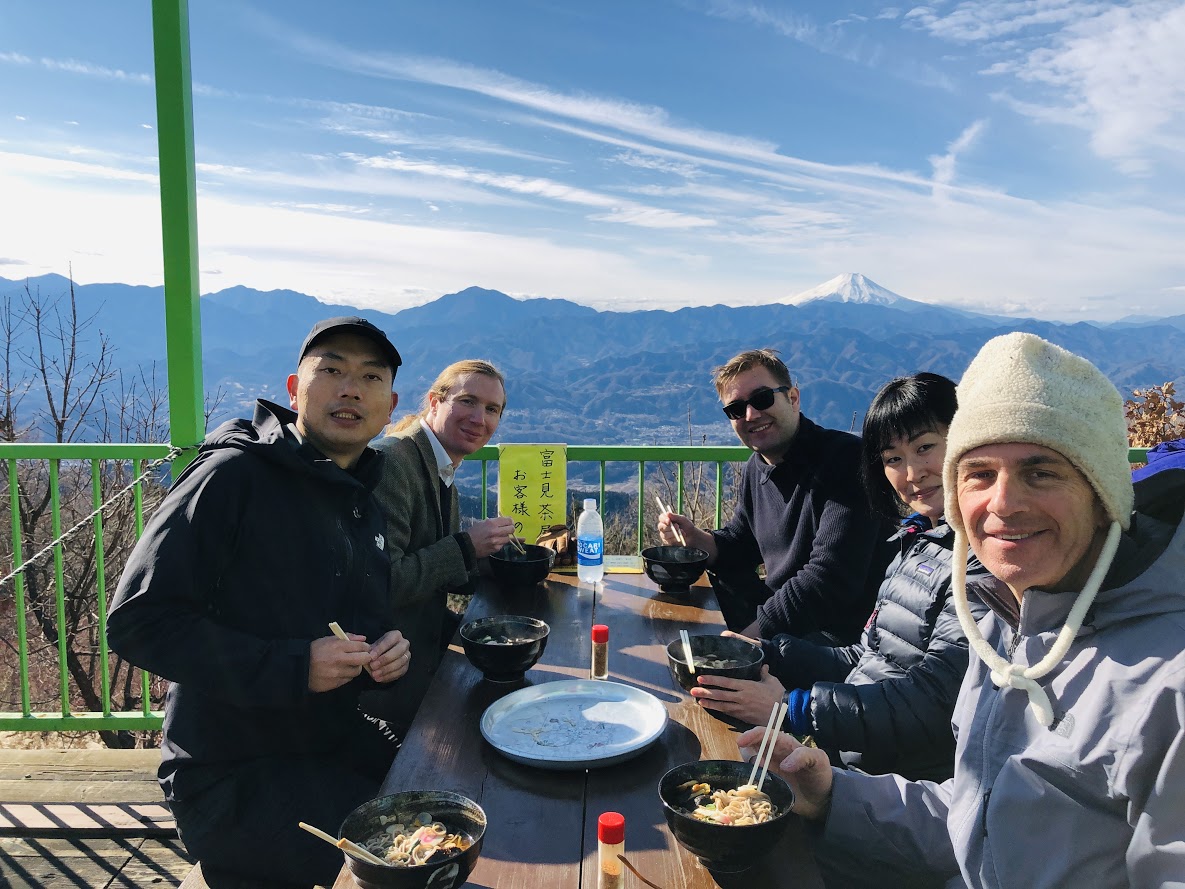
New Year’s Eve of 2018 with my hiker’s friends at a restaurant on the top of the Mt. Jimba. You can see Mt. Fuji on our background.
Area: Hachiōji city, Tokyo, Japan
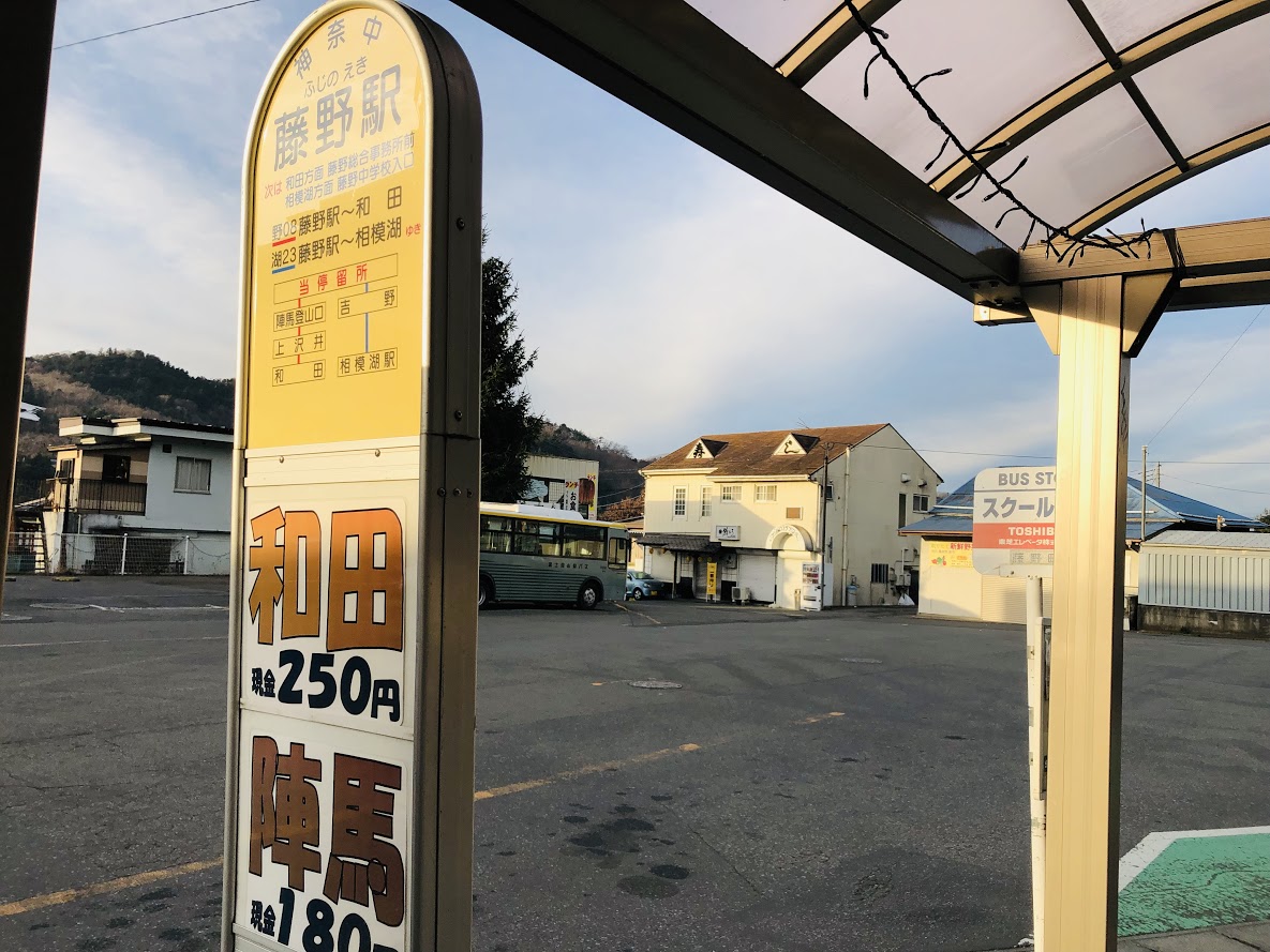
Access: Fujino Station (Fujino-eki, 藤野駅) on the Chūō Main Line of East Japan Railway Company, board a bus bound for Wada (和田) for 5 minutes, get off at Jimba trailhead (Jimba-tozanguchi, 陣馬登山口)
Start: Jimba trailhead bus station (Jimba-tozanguchi, 陣馬登山口)
Goal: Jimba trailhead bus station (Jimba-tozanguchi, 陣馬登山口)
Difficulty of this trail: ★ ☆ ☆ ☆ ☆
Trail appearance rate: ★ ★ ★ ☆ ☆
Total distance: 9 km
Total difference in elevation: 661 m
Walking time: 4 hours and 40 minutes
Point of interest: Good views of surrounding mountains (including Mt. Fuji and the Knatō Plain) , a bowl of soba noodles at restaurants of the summit, mountain village, hot spring, Japanese macaque (in winter).
Access to Jimba trailhead bus station (Jimba-tozanguchi, 陣馬登山口)
Please refer to the following for detailed access method.
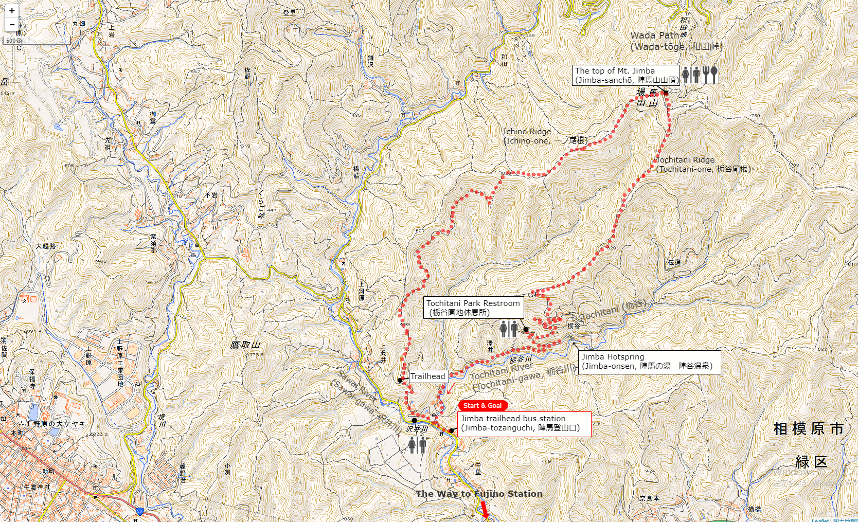
A Map of Mt. Jimba Hiking Course | Click on the image above to open the enlarged image in a separate tab.
The source of above the three maps are “Digital Japan Web System” of The Geospatial Information Authority of Japan. The maps were edited a author of this blog.
In Japanese: これらの3枚の地図は国土地理院の電子国土Webシステムから配信されたものをこのブログの著者が加工したものである。
From Jimba trailhead bus station (Jimba-tozanguchi, 陣馬登山口) to the Top of Mt. Jimba (Jimba-sanchō, 陣馬山山頂)
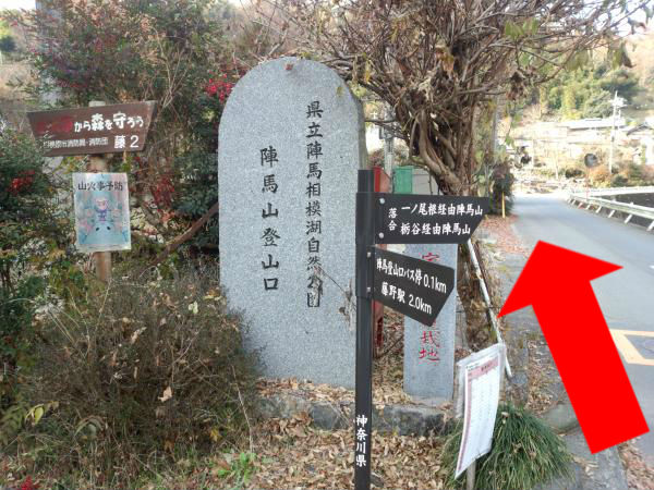
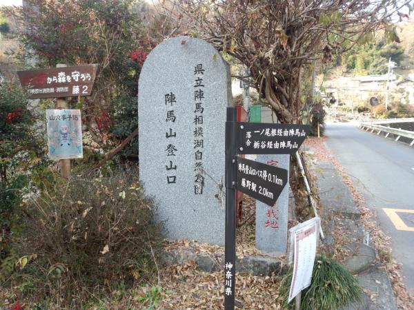
Walk along the road in the same direction as the bus wast traveling. You can find a sign beside a stone monument signposted “Mt. Jimba via Ichino Ridge” (一ノ尾根経由陣馬山) on the right side as you go about 100 meters.
Turn right at the sign written “Mt. Jimba via Ichino Ridge” (一ノ尾根経由陣馬山).
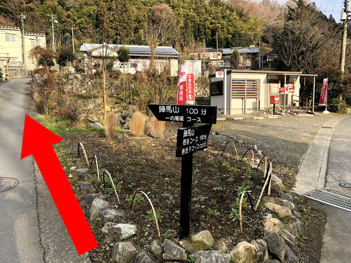
As soon as you turn right at the T-junction as follow of the sign, you can see a sign in front of post office signposted “Mt. Jimba 100 minutes Ichino Ridge Course” (陣馬山 100分 一ノ尾根コース) .
Turn left at the sign written “Jimba 100 minutes Ichino Ridge course” (陣馬山 100分 一ノ尾根コース).
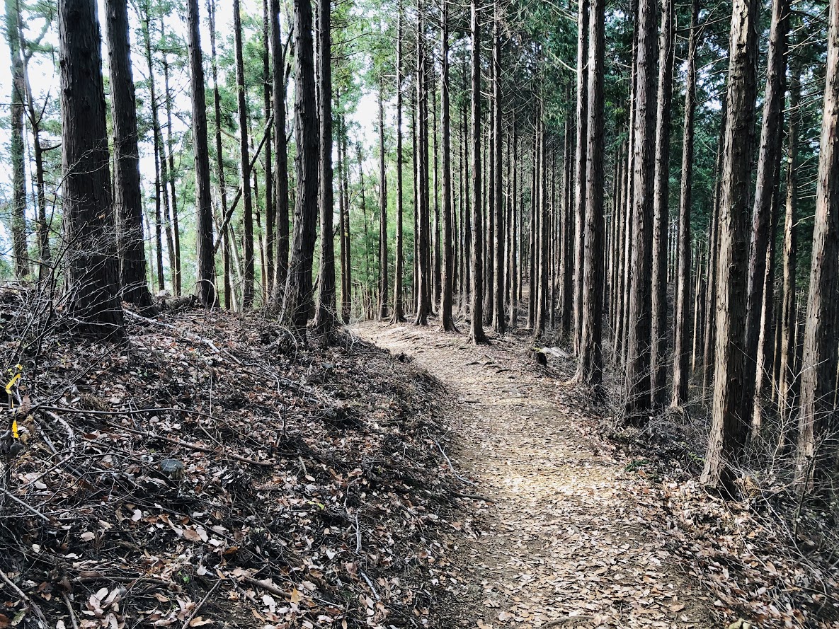
Follow the signboard and turn left, the path ascend from here. After ascend slope for about 20 minutes you will see a sign written “Mt. Jimba 4.0 km”. This sign is the trailhead of Mt. Jimba and after that the path become dirt trail. After turning to the left according to the direction of signboard, the trail though the beautiful ceder forest in about 1 hour and a half.
the beautiful ceder forest
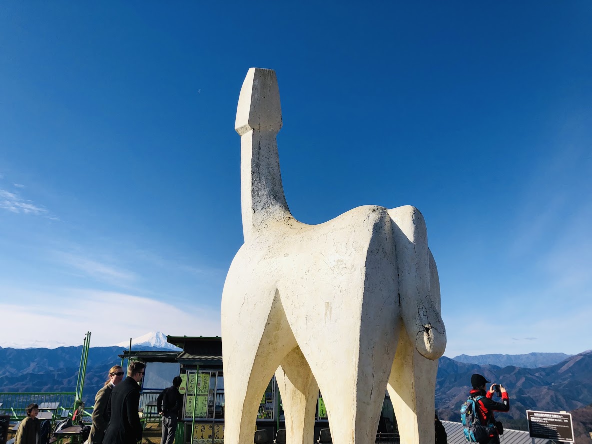
When you ascend the steep staircase, there is the mountain peak of Mt.Jimba. You can see 360-degree awesome panorama view include Mt.fuji and Kanto plain, Sagami Bay from here.
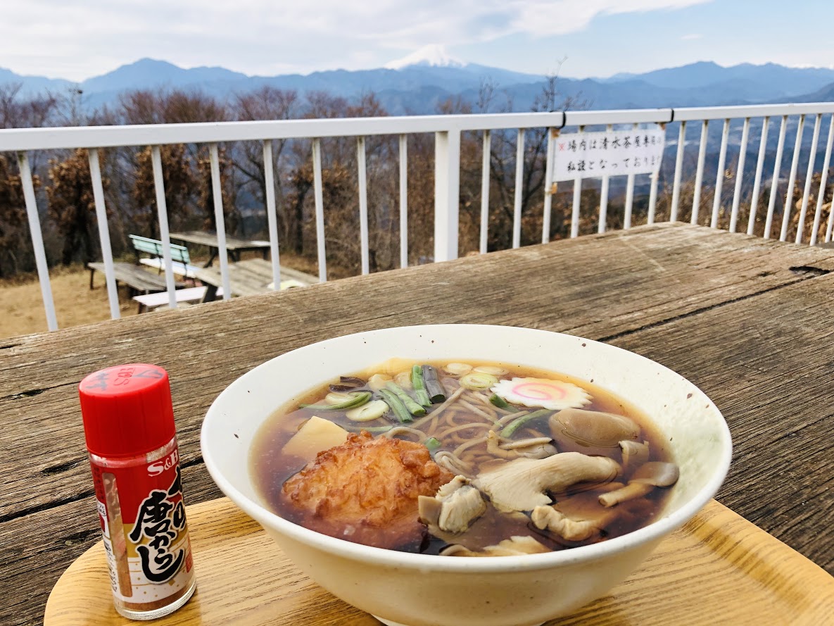
This place might be a best place to have a lunch, because there are three restaurants and hiking tables and benches on the summit of Mt.Jimba. Those shops offer some snacks and beverages including alcohol. Personally, I think the most delicious meal in those restaurants is a soba noodle with various vegetables and mushrooms (Jimba-soba, 陣馬そば) at Shimizu Tea-shop(Shimizu-jaya, 清水茶屋).
A soba noodle with various vegetables and mushrooms (Jimba-soba, 陣馬そば) 600 JPY
From the Top of Mt. Jimba (Jimba-sanchō, 陣馬山山頂) to Jimba trailhead bus station (Jimba-tozanguchi, 陣馬登山口)
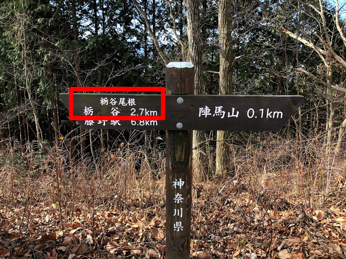
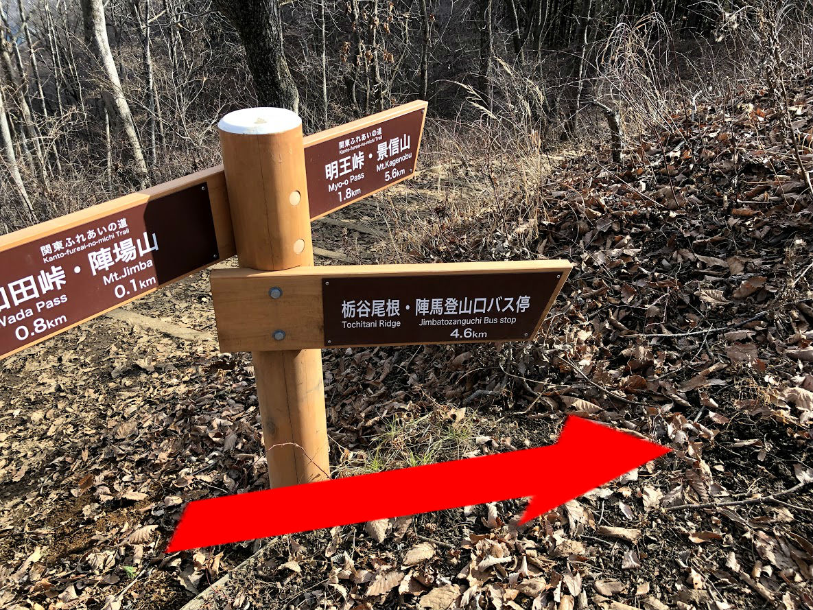
The way to Jimba trail head bus station goes via Tochitani Ridge (Tochitani-one, 栃谷尾根). But there are no signposted Tochitani Ridge (Tochitani-one, 栃谷尾根) on this area. The way to return is on the left side path of the Fujimi Restaurant (Fujimi-chaya, 富士見茶屋) which is the most highest place restaurant on the summit.
Note that there are no signposted “Tochitani Ridge” (栃谷尾根) which is our return way on top of Mt.Jimba.
If you down stairs beside Fujimi restaurant, there is a signboard written “Tochi-tani 2.7 km” (栃谷 2.7 km) ahead 100 meters from the restaurant, you can go to Tochitani Ridge as follow this sign.
Ignore paths branching off to the left side, a little farther on. There is a new branch and then veer right side path at this branch as follow signposted “Tochitani Ridge and Jimba Trailhead Bus Stop” (栃谷尾根 陣馬登山口バス停).
A steep descent leads down to cedar and cypress forest. There are the most steep slope in this hiking course, let’s walk slowly with attention to slips and falls.
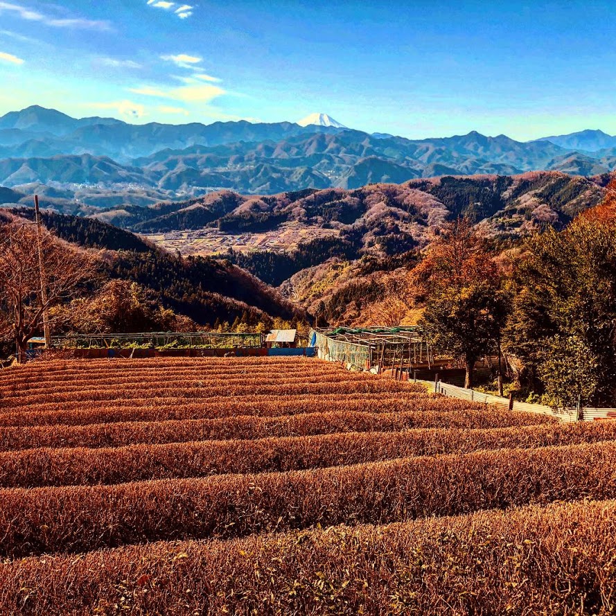
After 1 hour and 20 minutes or so, you reach Tochitani village, you can see tea plantations and yuzu plantation against superb view of Mt. Fuji. If it’s winter, you can buy sweet smell yuzu at the roadside stand.
Tochitani (栃谷) is a relaxing village with tea fields and Yuzu fields.
Go through the path in the village. After a while there is a place named “Tochitani Park Restroom” (栃谷園地休息所) with a bath room and a table and chairs. You can wash your boots in the tap with a brush.
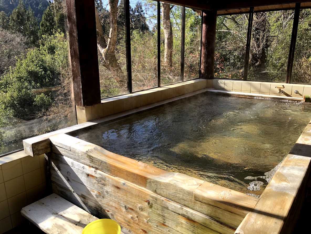
Just over 5 minutes leaving “Tochitani Park Restroom”, at a brunch signposted 陣屋温泉 where the path to the left to Jinya Hot Spring (Jinya-onsen, 陣屋温泉). If you visit the hot spring, bathing fee is just 1000 JPY.
You can enjoy a Japanese cypress wood bathtub at Jinya hot Spring. I recommend to carry a towel.
In 20-30 minutes, after passing the previous branch signposted hot spring, you can find a post office which you saw in this morning. You are a bus stop soon if you turn left at the T – junction ahead and go about 100 meters.
Note: The bus on the way back are very few numbers.
Even if there is no convenient bus, it is about 20 minutes on your foots to back Fujino station. The timetable of returning bus is here.
There are no parking lots around Jinba Trailhead Bus Station (Jinbatozanguchi-bustei, 陣馬登山口バス停).
If you come by car there is a parking lot around Fujino station.
The following is the pay parking lot closest to the Fujino station.
Google Map of a parking lot around Fujino station
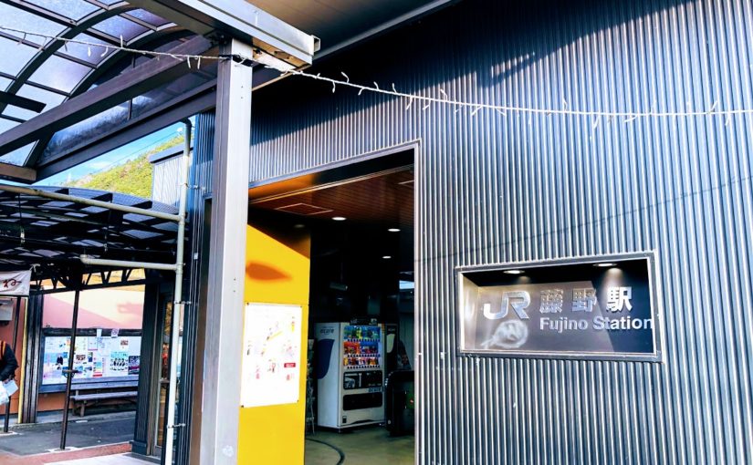
From Fujino (藤野) station station to Jimba trailhead bus station (Jimba-tozanguchi, 陣馬登山口)
Leave the station by the only exit, and down stair, walk slightly to the right to Bus Stand outside, and board a bus bound for Wada (和田).
After about 5 minutes, get off at Jimba trailhead bus station (Jimba-tozanguchi, 陣馬登山口). The fare is 180JPY.
In Case of Using Train and Bus
From JR Shinjuku (新宿) station to Fujino (藤野) station
From JR Shinjuku station, take a Chūō Line (中央線) ordinary train (futsū, 普通), bound for Ōtsuki (大月) or Kōfu (甲府), to Fujino (藤野) station. These leave from Platform 7, 9, or 10, depending on the time. Take care not to board the more luxurious long-distance trains, which levy a surcharge and do not stop at Fujino.
If the departure times are inconvenient, catch the special rapid train (tokubetsu kaisoku, 特別快速) or rapid service train (kaisoku, 快速) from Platform 10 to Tachikawa (立川), Hachiōji (八王子), or Takao (高尾) station (trains with Takao as their destination have the most frequent connections), and transfer, since some trains that are suitable originate from here bound for Ōtsuki, Kōfu, Kobuchizawa (小淵沢), and Matsumoto (松本).
The fare is from Shinjuku to Fujino is 972JPY, and the journey takes 1 hour and 25-40 minutes (excluding connecting time).
Please check the latest timetable, because the timetable and fare are sometimes changed.
Timetable and Route Serch “HyperDia” http://www.hyperdia.com/sp/index.html.en
There are two bus stops, but on the far side of the right.
Leave the station by the only exit, and down stair, walk slightly to the right to Bus Stand outside, and board a bus bound for Wada (和田).
After about 5 minutes, get off at Jimba trailhead bus station (Jimba-tozanguchi, 陣馬登山口). The fare is 180JPY.
Note: The bus going are very few numbers.
Even if there is no convenient bus, it is about 20 minutes on your foots to go Jimba trailhead bus station. The timetable of going bus is here.
Google Map of Jinbatozanguchi Bus Stop
In Case of Walking from Fujino Station to Jinbatozanguchi Bus Stop on foot
Leave by the only exit at Fujino Station and turn left in the direction marked “Mt.Jimba on foot” along rail way.
Some 3-5 minutes walk the road along the rail way, turn left and cross the railroadcrossing.
A little bit farther on there is a tunnel and go through out the tunnel and less than 15-20 minutes away is the bus the Jinbatozanguchi bus stop.
From Jinbatozanguchi Bus Stop go straight ahead and this stone monument is.