JR Ō me Line Mitake Station → Nishi-Tokyo Bus · “To Cable Shita” (8 minutes), Cable Car Takimoto Station → Mt. Mitake Station (6 minutes)
BELONGINGS:
• Non-slippery shoes for hiking
• water
• Snacks (sandwich, rice balls, chocolate etc …)
• Warm clothes and gloves and hat
• Towel
COURSE:
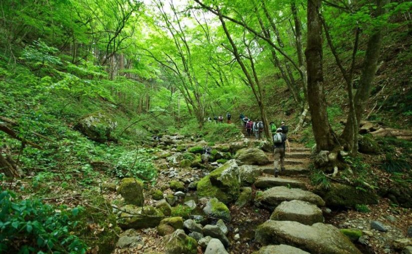
Mt. Mitake Station → Musashi-Mitake Shrine → Nagao-daira → Tengu Rock →
Rock Garden → Ayahiro Falls → Nagao-daira → Mt. Mitake Station
Waiver of Liability/Disclaimer: Please read before signing up for this event.
These organizers are not professional hikers or trained leaders and are not medically trained to handle emergencies. Hiking is an inherently dangerous activity that can lead to serious injuries including but not limited fall injuries, poison oak. By participation in this event/hike you agree to not hold these organizers liable for any harm that may come to you, or your property. Always remember to let the event organizer know if you are leaving the group. Stay on the trail, never hike alone and use your own common sense.
This event is a hiking for “Hosawa Waterfall” selected as “100 waterfalls in Japan” and “Asama Ridge” where you can enjoy walking ridges for novice hikers with little up / down.
Asama ridge is the season when Katakuri (dogtooth violets) blooms just this season.
Also, because it is cherry blossom season, you may be able to watch them at the same time if you are lucky. https://www.at-roadside.com/drive/metropolitan/sengenrei3.html
In addition, the Asama Ridge is an important road from old times, called Koshu way, which connects both countries of Bushu and Koshu, in the Edo period was a road for an important life for charcoal transport.
Let’s relax and enjoy hiking while thinking of old time people in spring fresh green trail.
The meeting place is Musashi-itsukaichi Station on JR Itsukaichi Line, meeting time is 8: 34 am.
From Musashi-itsukaichi Station, we take a bus to “Honjuku-yakubamae”.
The departure time of the bus is 9: 00 am.
The return bus is scheduled for 14: 55 pm.
※ The schedule may change, please be forewarned.
Route advice:
The area around the waterfall is slippery, you can enjoy safer hiking if you bring steigeisen.
BELONGINGS:
• Non-slippery shoes for hiking
• water
• Warm clothes and gloves and hat
SCHEDULE:
Musashi-itsukaichi station 08: 34 → bus departure time 09: 00 → Honjuku-yakubamae Bus Stop 09: 20 → Hosawa Waterfall bus stop 9: 30 → Hosawa Waterfall parking lot 10: 00 → Tosaka Pass 10: 30 → Asama Ridge observation deck 11 : 30 → lunch time → 12: 00 → Henbori Pass 12: 30 → guest‐house Asamazaka 14: 00 → Asamaone Trailhead Bus Stop 14: 45
※ The departure time of the return bus is scheduled for 14:55 PM.
※ We can wait at the Guest House Asama slope until the departure time of the return bus.
※ The schedule may change, please be forewarned.
Waiver of Liability/Disclaimer: Please read before signing up for this event.
These organizers are not professional hikers or trained leaders and are not medically trained to handle emergencies. Hiking is an inherently dangerous activity that can lead to serious injuries including but not limited fall injuries, poison oak. By participation in this event/hike you agree to not hold these organizers liable for any harm that may come to you, or your property. Always remember to let the event organizer know if you are leaving the group. Stay on the trail, never hike alone and use your own common sense.
Booking Now
Please reserve this event from the following Meetups.
The hiking course of Sengen ridge (Sengen-one, 浅間尾根) offers beautiful mountain views and Hosawa waterfall. You can access to this trailhead for about 1 hours and a half from Shinjuku station. This trail was an important road from old times, called Koshu way (甲州道), which connects both countries of Bushu (武州) and Koshu (甲州), in the Edo period was a track for an important life for transporting charcoal. Let’s relax and enjoy hike while thinking of old time people in the clear air which hard to believe you’re still in Tokyo.
You can walk enjoying fine views of such nearby peaks as Mt.Gozen on your right side.
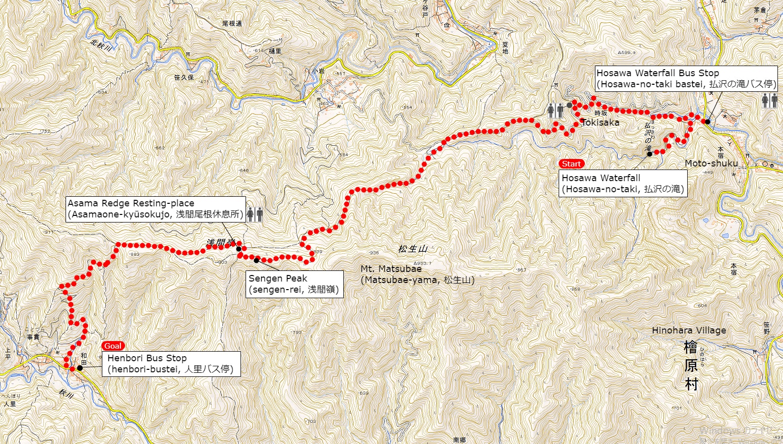
Area: Chichibu-Tama National Park, Hinohara village, Tokyo
Access: Musashi-Itsukaichi Station (武蔵五日市駅) on JR Itsukaichi Line, get off at Hosawa Waterfall Entrance (払沢の滝入口). For more information, click here
Start: Hosawa Waterfall Entrance Bus Stop (払沢の滝入口バス停)
Goal: Henbori Bus Stop (人里バス停)
Difficulty of this trail: ★ ☆ ☆ ☆ ☆
Trail appearance rate: ★ ★ ☆ ☆ ☆
Total distance: 8 km
Total difference in elevation: 661 m
Walking time: 3 hours and 30 minutes
Point of interest: Hosawa Waterfall (particularly in winter), wildflowers (spring to autumn), mountain views, japanese macaque (winter), an Edo-period track for transporting charcoal.
Access to Hosawa Waterfall Entrance (Hosawa-no-taki-Iriguchi, 払沢の滝入口)
Please refer to the following for detailed access method.
A Map of Sengen Ridge Hiking Route (include Hosawa Waterfall)
A Map of Sengen Ridge Hiking Course | Click on the image above to open the enlarged image in a separate tab.
The source of above the three maps are “Digital Japan Web System” of The Geospatial Information Authority of Japan. The maps were edited a author of this blog.
In Japanese: これらの3枚の地図は国土地理院の電子国土Webシステムから配信されたものをこのブログの著者が加工したものである。
From Hosawa Waterfall Entrance Bus Stop (払沢の滝入口バス停) to Sengen Peak (Sengen-rei, 浅間嶺)
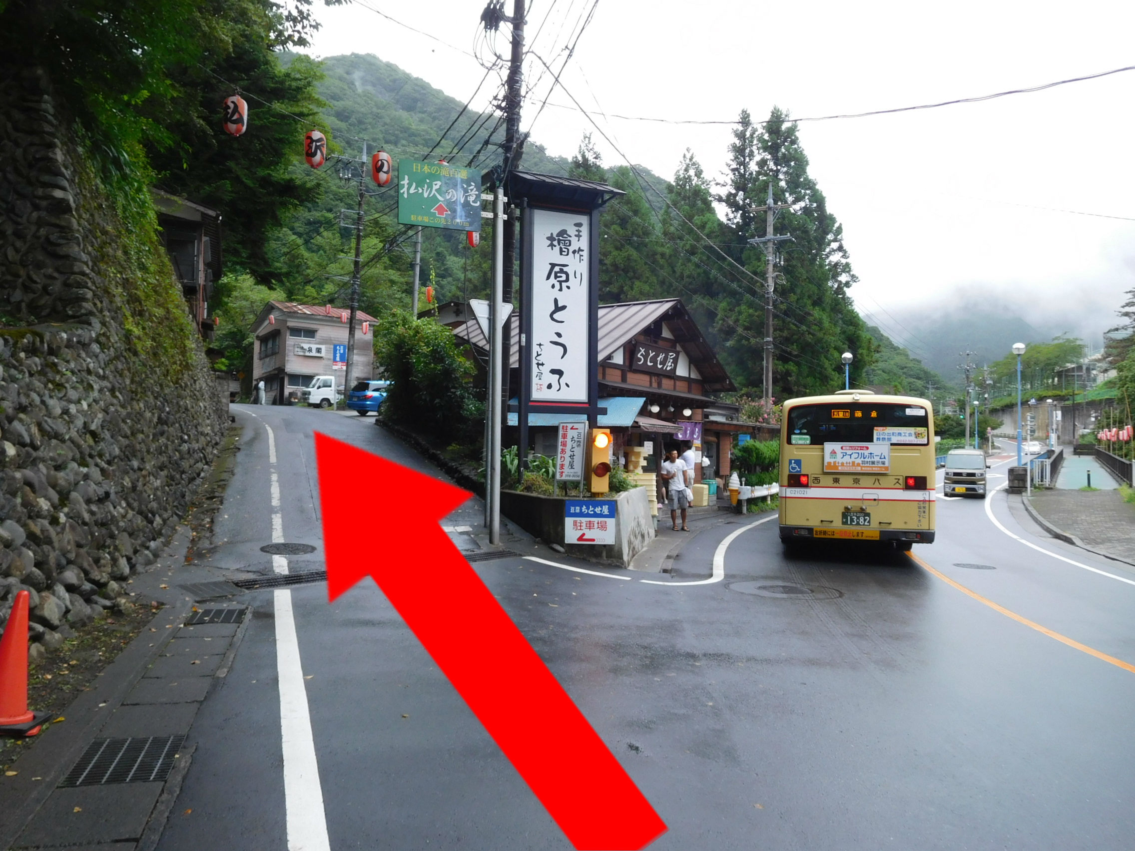
I also recommend popular menu fried donuts and soy milk, both of which are 100 yen at this tofu shop.
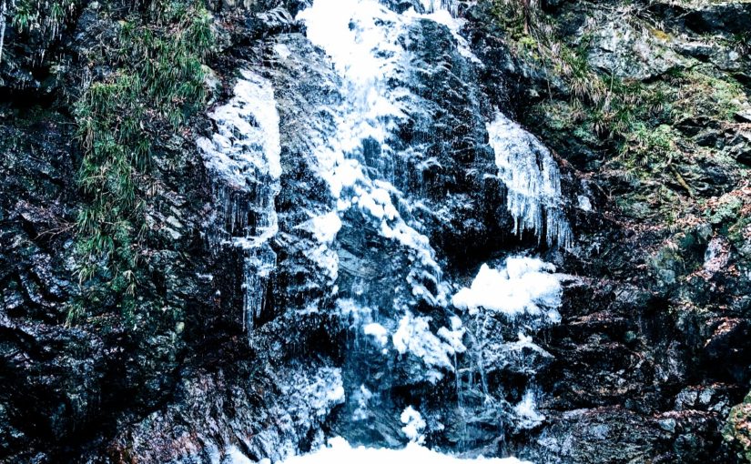
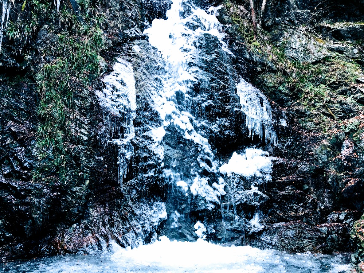
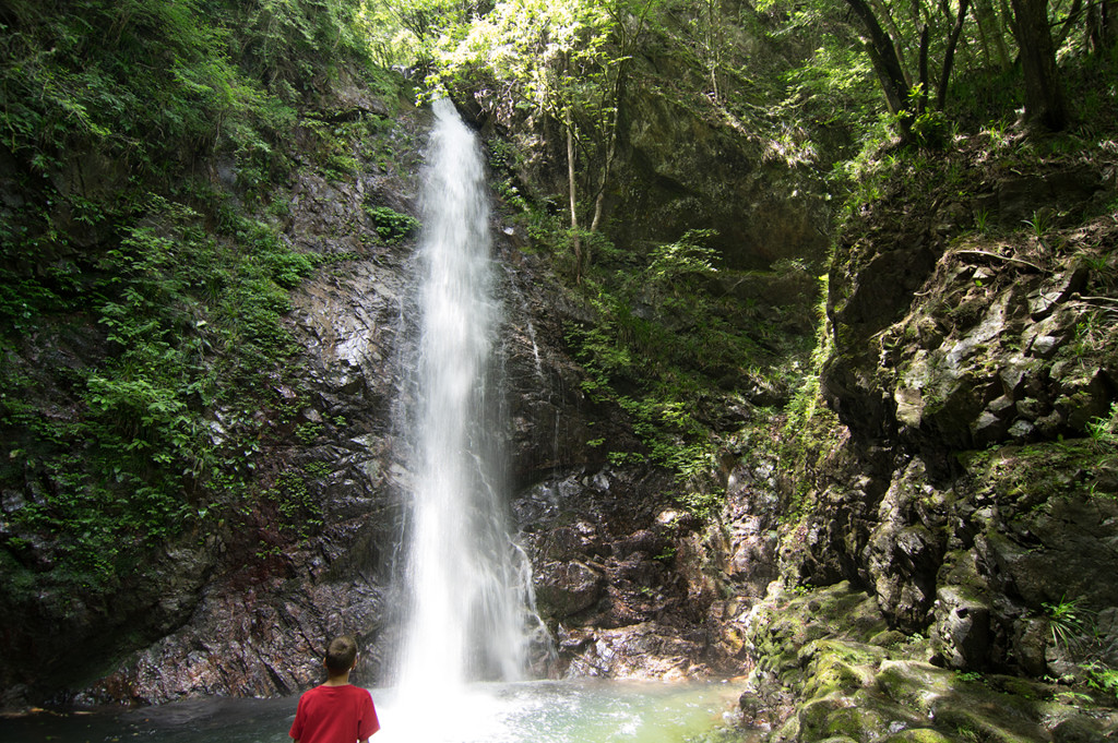
A sign above the road next to left side of the Tofu shop (檜原とうふ ちとせ屋) reads “Hosawa Waterfall” (Howasa no taki, 払沢の滝). Following this sign, go to the narrow road a little bit further on. To get to the waterfall, veer left at a fork a few minutes later onto a dirt path also marked for Hosawa waterfall, though with a simplified first character (払沢の滝). The waterfall is 5-10 minutes along this high rocky path, which crosses several small bridges. In winter, parts of the 60-meter fall and most of the pool at the bottom freeze over, and the icicles hanging off the face make for a splendid sight.
Hosawa Waterfall freezes from late January to early February. This photo above is February 2, 2019.
After visitting the waterfall, return to the previous junction, turn hard left in the direction of Sengen Ridge (Sengen-one, 浅間尾根). This path merges with a dirt road, which you follow uphill to the large bitumen road and bear left. The trail leaves and rejoins this road several times over the next kilometer or so, and passes many old wooden houses.
A few minutes further on, at the sign for “Zizaka Pass, Sengen Peak” (時坂峠 浅間嶺), take the steps up to the left. Rejoin the road 10 minutes later, again heading uphill to the left. The path (similarly signposted) resumes sharply to the left after about 10 more minutes. From here it zigzags up the hill, crossing the road (at a similar sign) after 5 minutes.
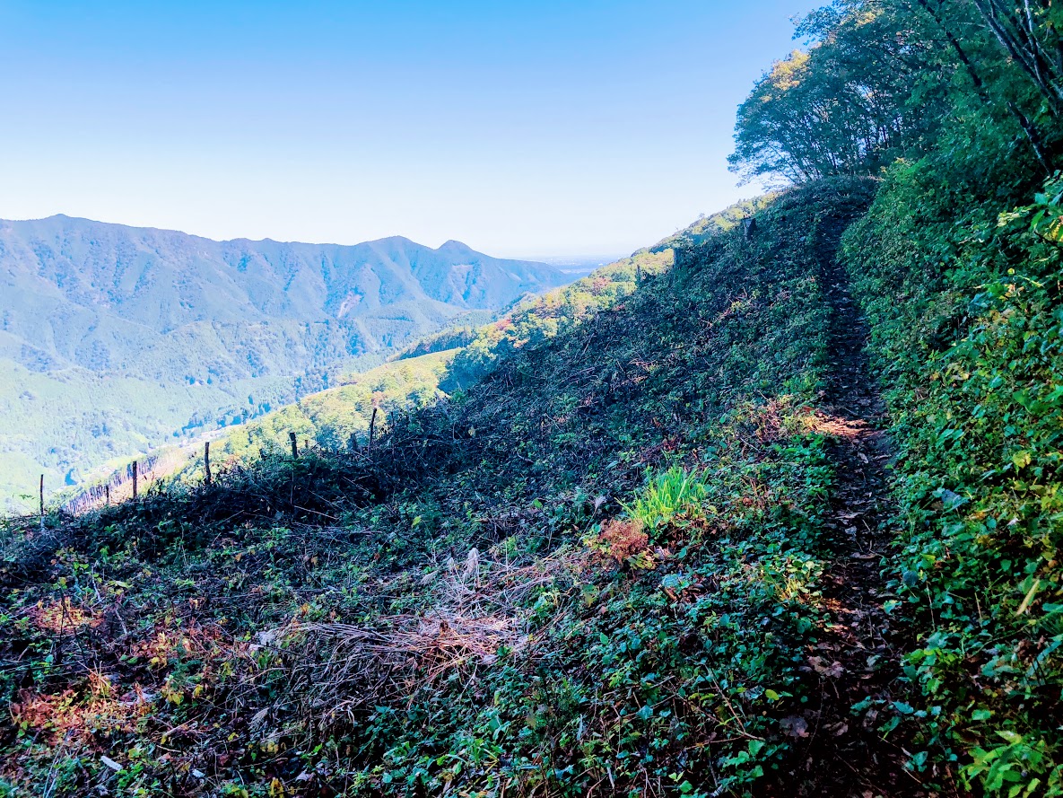
The Path soon bend left (near a tiny shrine), and begins to trace the line of Sengen Ridge, merging with the dirt road that enters from the left after 5-10 minutes.
This farmhouse has been built more than 400 years.
Walking for 7 minutes or so will bring you to a magnificent old farmhouse, rustic sheds, and a water supply system consisting of lengths of bamboo split in half to form open pipes, which are joined together and connected to a nearby stream. This was a soba noodle shop until 2018, but unfortunately closed down now.
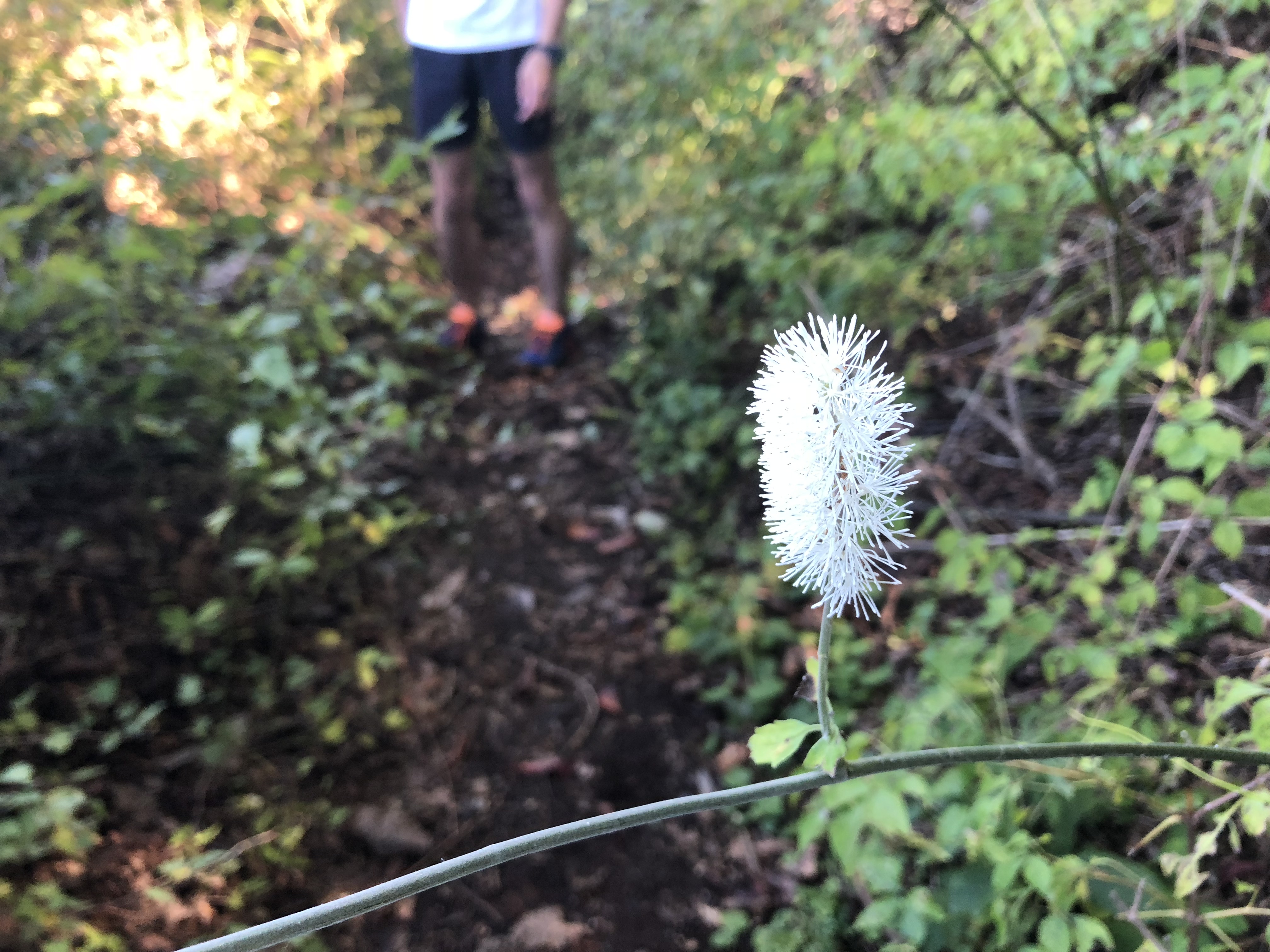
Ascend steeply for 30-40 minutes, first next to small stream and past rock pools, and latter through a forest with broad-leaved magnolia trees (and where orange fungi used in a herbal cancer treatment can be fond). There are also many wildflowers at various times of the year, such as summer yamayuri (gold-banded lily).
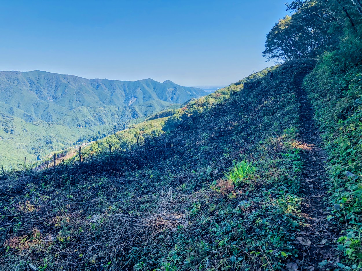
After passing more open area with fine views of such nearby peaks as Mt.Gozen, you come to the junction marked “Observation Deck and Sengen peak” (展望台 浅間嶺) pointing to the left.
Turning left as follow this sign, ascend moderate slope for a while.
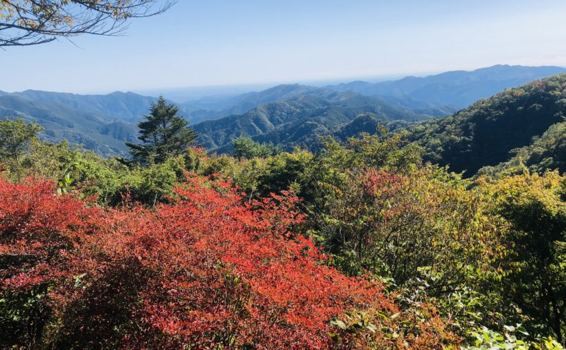
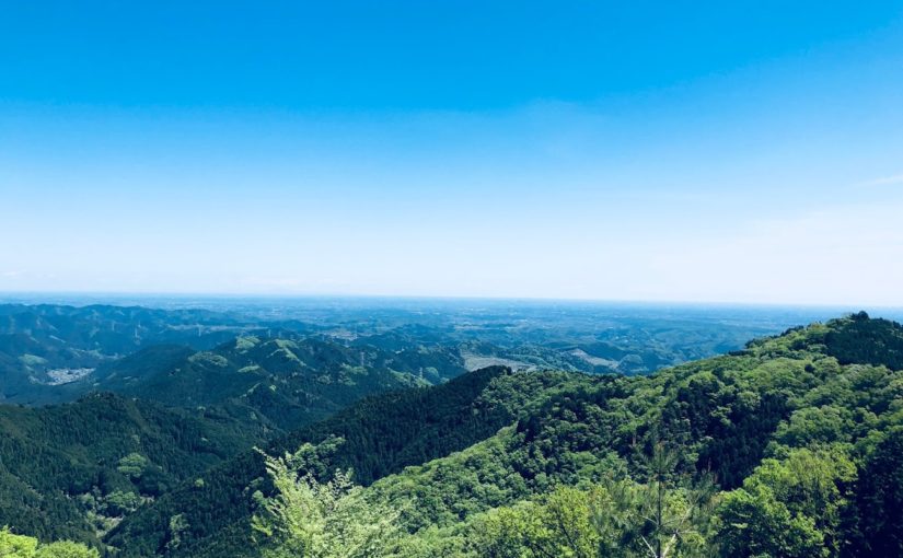
After walking for 10-15 minutes, you arrive at the highest point (904 meters above sea level) on Sengen Ridge. From there, you can enjoy superb views including Mt.Fuji and mountains of Okutama area.
From there, you can enjoy superb views including Mt.Fuji and mountains of Okutama area. Suitable area for lunch is Asama Ridge Resting-Place descending right side from here for approximately 3-5 minutes.
There are picnic area with tables and chairs, a shelter, a fire place, and toilets.
Since snow may be piled up during the winter, let’s bring micro crampons. This photo above is February 2, 2019.
The map board provides some history of the area, as follows:
KANTŌ COMMUNITY ROADS Historical Path The 8 kilometer route from Kami-Kawanori to Honjuku leads up in the direction of Sengen Ridge and traverses Jizaka Pass. Passing through the middle the Hinohara-mura area and tracing the comparatively moderate lie of the land, Sengen-one Road, also called Naka-Kōshū Road, has form olden times been an important traffic thoroughfare. During the Edo priod, it was an important route for hauling charcoal by horse and for the transport of daily necessities. Besides the village folk, people from Ogouchi and Saihara also used the trail.
Another interesting feature of this area is the presence of the Japanese macaque, which descend in winter from the cold upper reaches of the surrounding mountains to these slopes. They are quite shy and more likely to be sighted on the southern side of the ridge.
From Sengen Peak (浅間嶺) to Hembori Bus Stop (人里バス停)
There is a descend slope on the left side of the map board. After few meters on this slope there are the signposted junction. Turn left as fallow marked “Kazehari-touge and Hembori Bus Stop” (風張峠・人里バス停).
After 5 more minutes you go straight through another T-junction. From here, simply follow the Hembori (人里) signs for about 25 minutes, keeping with an adjacent bamboo stand, to a concrete road near some tea plantations. You take this road down past a few houses to the main road. Hembori bus stop is immediately to your right.
The bus ride to Musashi-Isukaichi Station takes about 45 minutes, and the fare is 820 JPY. To return to Shinjuku Station, in any case follow in reverse the instructions provided in bellow article for this walk.
Difficulty: ★ ☆ ☆ ☆ ☆
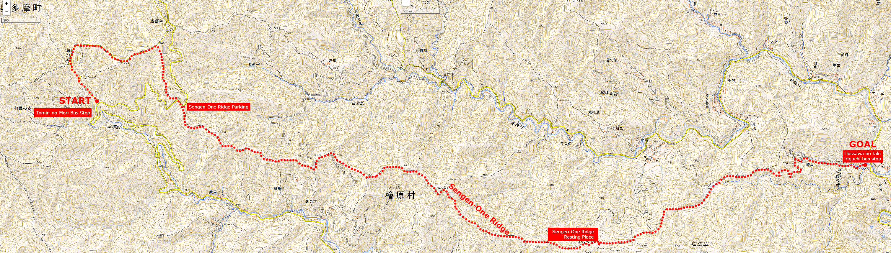
Start spot: Tomin-no-Mori Bus Stop 都民の森
Goul spot: Hossawa no taki iriguchi bus stop 払沢の滝入り口バス停
Total distance: 15.7 km
Total difference in elevation: 963 m
Hiking Course overview
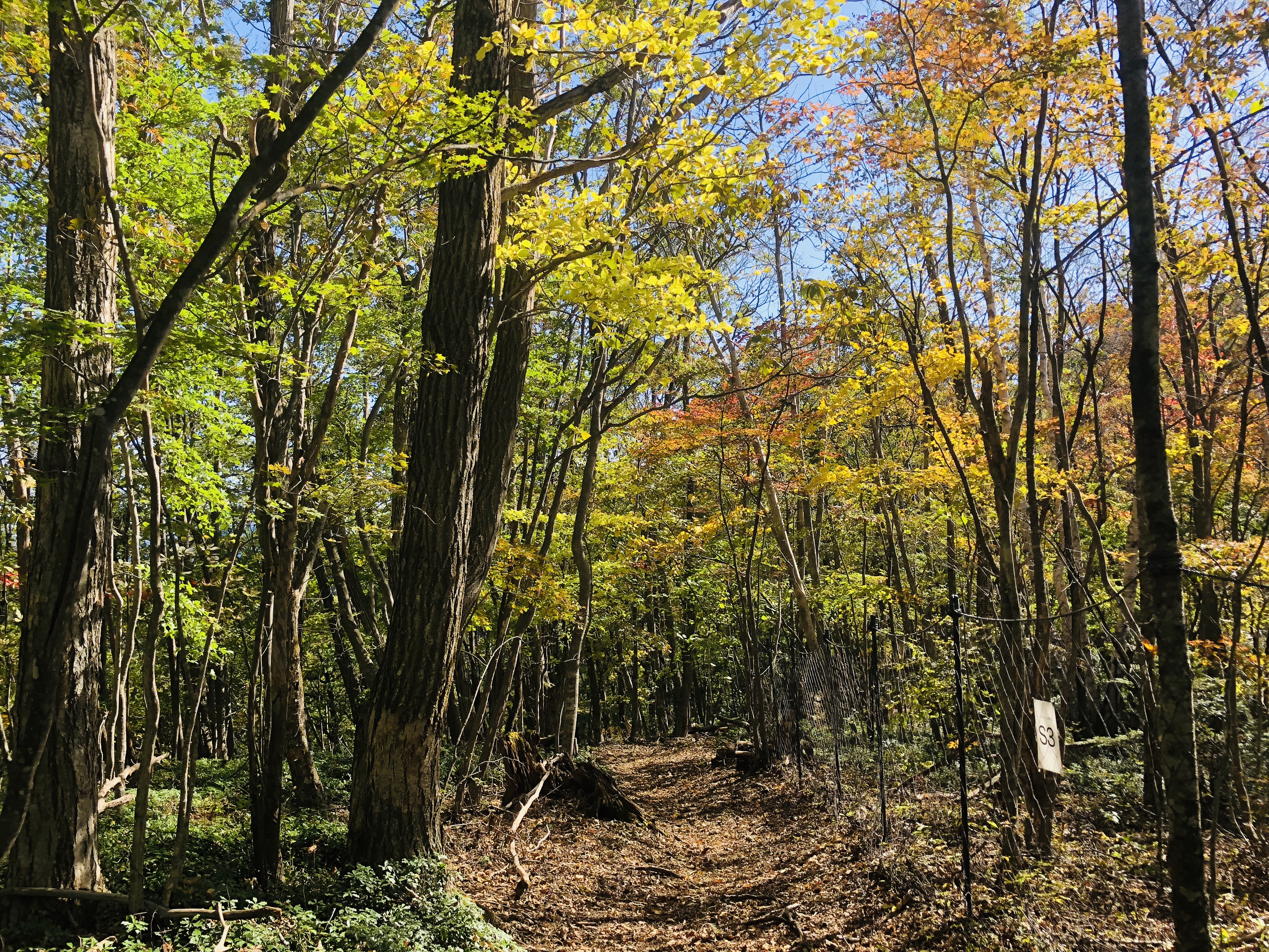
Go through the pleasant forest of a single track with few ups and downs.
1). Hinohara-Tomin-no-Mori Bus Stop 檜原 都民の森
2). Sengen-One Ridge Parking 浅間尾根駐車場
3). Sengen-One Ridge 浅間尾根
4). Sengen-One Ridge Resting Place 浅間尾根休憩場
5). Hossawa no taki iriguchi bus stop 払沢の滝入り口バス停
Map of “Sengen-One” Hiking Course
Clicking the image will display the enlarged size with a new tab.
Access
“Tomin-no-mori” is the trailhead of Mt. Mitou popular with hikers. Hiking routes are stretched all around in this area, but let’s proceed to “Kaze-hari-touge 風張峠” in this area.
JR Musashi-Itsukaichi Line End · From Musashi-Itsukaichi Station, take the West Tokyo bus to “Tomin-no-Mori Bus Stop 都民の森 バス停” for about 1 hour and 10 minutes.
On the way back, “the Hossawa no taki iriguchi bus stop払沢の滝入口 バス停” is used.
Or if you move to “Moto-shuku-yakubamae bus stop 本宿役場前 バス停”, the number of buses is large.
There is a free parking lot in “the Hossawa no taki iriguchi 払沢の滝入口”.
ADVICE
There is no public drinking fountain to the end of the course.
However, since there is a shop, vending machine, and toilet in the starting point “Tomin – no – Mori”, you can prepare here for running.
There is a lot of escape route to paved road called Hinohara – Kaidou in the way of Sengen – One, so beginners are safe course.
Features of “Sengen-One” course
The origin of the name of the ridge, “Sengen-One Ridge” is the highlight of the course.
This course is known to special people, you can down hill like crazy.
If you are thinking that “climing is the best part of hiking”, “You have ups and downs in life”, for such a hikers, this course can not be recommended. (I’m sorry)
Because the bus carries you to a high place, the course is generally in descending and on the way it is a runable trail with a flat part of about 5 km.
Therefore this course will be the best course for your hiking debut in Tokyo.
First of all,
Depending on the signpost in “Tomin-no-mori” you will go to “Saiguchi-Touge 鞘口峠”
It’s just a fine climb up to your warm-up.
Let’s proceed from “Saiguchi-Touge 鞘口峠” to “Kaze-hari-Touge 風張峠”.
As you go about 1.5 km, if the signpost of “Sengen-One 浅間尾根” appears, proceed to “Sengen-One 浅間尾根” direction.
Let’s move carefully since there are parts where the trail around here is collapsing.
Once you leave the paved road and enter the dart road again, the downhill of “Sengen-One Asama Ridge” will begin.
Because this course is easy to walk anyway, it is a satisfying course for those who want to run alone, those who want to enjoy at their own pace, both types of people.
Furthermore, since there are many escape routes and signs are substantial, I really recommend it for debuting hiking in Tokyo.
It is certainly inconvenient that the bus is indispensable to the starting point of the hiking course, but thanks to that, the course has few people crowded.
Moreover, it is mostly gentle downhill, mostly single track, you can monopolize luxurious course.
Perhaps you will face your face with your colleagues and say “Feel so good!”
After hiking…
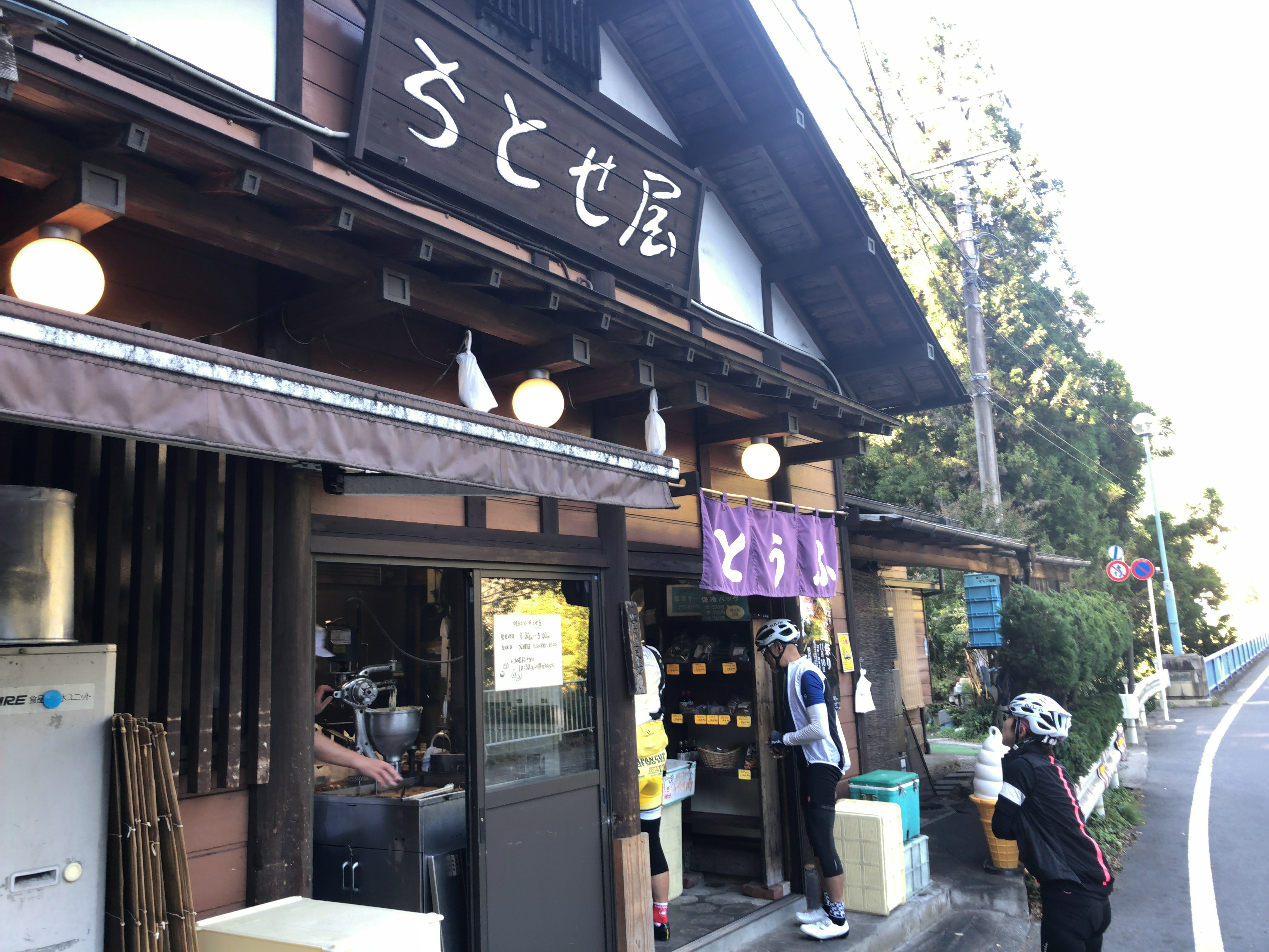
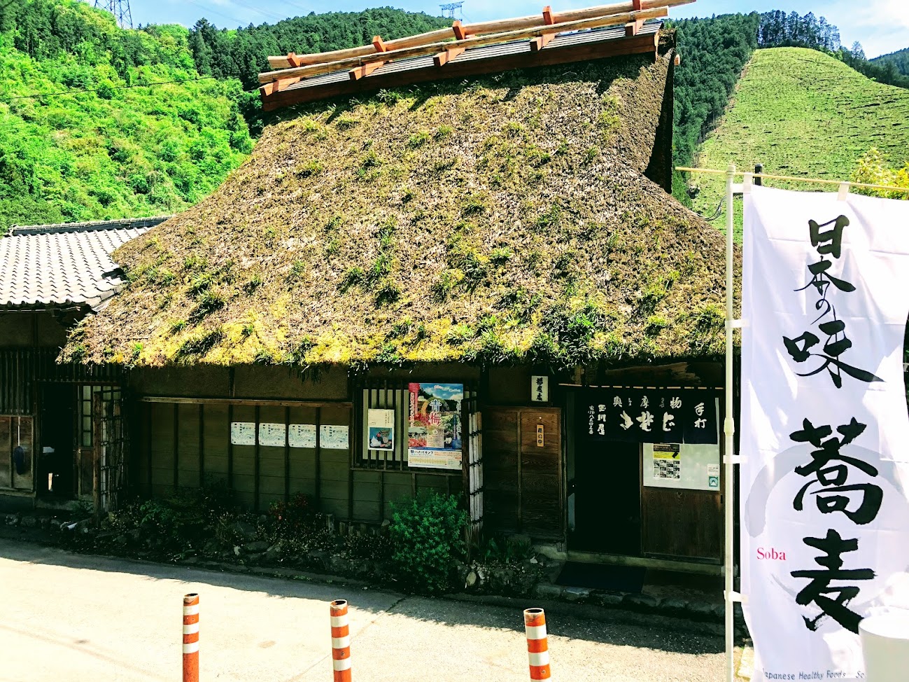
Hinohara-Tofu Chitose-ya
Tofu store in front of “Hossawa no taki iriguchi bus stop”.
Tofu using Hinohara’s source water and Hokkaido soybean is a rich flavor.
We also recommend popular menu fried donuts and soy milk, both of which are 100 yen.
Do you need a guide for this hiking course?
If you are looking for guide of this hiking course, please refer to the following.
This hiking course is a secret long trail that you can experience a moderate downhill that continues in Tokyo in Japan.
The hiking Course in the west mountain area of Tokyo is named “Sengen-ridge”, you can arrive by train and bus in about two hours.
You may feel a little far, but as you get off the bus it is a world of altitude 1000 meters. Then only you can down hill like crazy with enjoying beautiful nature and lovely flowers and magnificent mountains.
If you are a hiker, and if you plan to come to Tokyo, I’d definitely want to introduce you to the course.
Tour details
Price : 3500 yen per person
Distance : 15.7 km
Private Tour (Your family and friends are OK.)
Difficulty : ★☆☆☆☆
Language : English, Japanese
Meeting point : Shinjuku Station or Musashi-itsukaichi station (武蔵五日市駅) on the JR Itsukaichi Line.
The exact meeting point will be set by your guide after booking confirmation, but I respond flexibly according to your area of accommodation. Transportation to the start point is not included in the tour price.
Meeting time : It is necessary to arrive at Musashi-itsukaichi station at least at 8:45 am because of the departure time of the bus.
What you can experience at this Course :
・Hosawa Waterfall
・Wildflowers (spring to autumn)
・Mountain Views
・Soba Restaurant in Mountain village (spring to autumn)
・Tofu Donuts Shop
・Hot Spring (optional)
There is a soba restaurant in this course and you can enjoy local food in traditional Japanese traditional houses. The final destination, Hosawa Waterfall, is a beautiful waterfall with a height of 62 meters, and it is the only one in Tokyo that has been chosen as “100 Japanese Waterfalls.”
There is a popular donut shop in front of the bus stop on the way back, and Tofu Donuts using soy pulp as a material is delicious.
For more information on this hiking course, click here.
Disclaimer
Please read and give me consent before booking for this tour.
Hiking is an inherently dangerous activity that can lead to serious injuries including but not limited to slip and fall injuries, fractures, snake bite, heat exhaustion, poison oak, ticks and frostbite. By participation in this event you agree to not hold these organizers liable for any harm that may come to you, your guests, or your property. Always remember to let the event organizer know if you are leaving the group. Stay on the trail, never walk alone and use your own common sense.
Booking Now
[contact-form-7 id=”4392″ title=”Private Hiking Guide to Sengen Ridge | Beautiful Long Down Hill in Okutama”]
This trail is a secret long trail that you can experience a moderate downhill that continues in Tokyo in Japan.
The trail in the west mountain area of Tokyo is named “Sengen-one-ridge”, you can arrive by train and bus in about two hours.
You may feel a little far, but as you get off the bus it is a world of altitude 1000 meters. Then only you can down hill like crazy with enjoying beautiful nature and lovely flowers and magnificent mountains.
If you are a trail runner, and if you plan to come to Tokyo, I’d definitely want to introduce you to the trail.
Tour details
Price : 3500 yen per person
Distance : 15.7 km
Private Tour (Your family and friends are OK.)
Difficulty : ★☆☆☆☆
Language : English, Japanese
Meeting point : Shinjuku Station or Musashi-itsukaichi station (武蔵五日市駅) on the JR Itsukaichi Line.
The exact meeting point will be set by your guide after booking confirmation, but I respond flexibly according to your area of accommodation. Transportation to the start point is not included in the tour price.
Meeting time : It is necessary to arrive at Musashi-itsukaichi station at least at 8:45 am because of the departure time of the bus.
What you can experience at this Course :
・Hosawa Waterfall
・Wildflowers (spring to autumn)
・Mountain Views
・Soba Restaurant in Mountain village (spring to autumn)
・Tofu Donuts Shop
・Hot Spring (optional)
There is a soba restaurant in this course and you can enjoy local food in traditional Japanese traditional houses. The final destination, Hosawa Waterfall, is a beautiful waterfall with a height of 62 meters, and it is the only one in Tokyo that has been chosen as “100 Japanese Waterfalls.”
There is a popular donut shop in front of the bus stop on the way back, and Tofu Donuts using soy pulp as a material is delicious.
Please read and give me consent before booking for this tour.
Trail running is an inherently dangerous activity that can lead to serious injuries including but not limited to slip and fall injuries, fractures, snake bite, heat exhaustion, poison oak, ticks and frostbite. By participation in this event you agree to not hold these organizers liable for any harm that may come to you, your guests, or your property. Always remember to let the event organizer know if you are leaving the group. Stay on the trail, never run alone and use your own common sense.
Booking Now
[contact-form-7 id=”4387″ title=”Private Trail Running Guide to Sengen Ridge | Beautiful Long Down Hill in Okutama”]
This is popular course of Okutama which walking in three peaks.
With about 4 hours of walking, It is a luxurious course that you can taste three mountain peaks, “Mt. Takizumi”, “Mt. Iwatakeishi” and “Mt. Sougaku”.
Easy access with public transportation is also GOOD!
It takes about 1 hours and a half by train from Shinjuku to Okutama
JR 軍畑 Ikusabata station~高源寺 Kougenji Temple(about 30 minutes)
軍畑 Ikusabata Station to 高源寺 Kougenji Temple we walk on a general road where gentle climbing continues. The Hiramizo River flows on the right side of the road, making you feel cool. There is a toilet for 1 person in the Kougen temple.
Start from JR Ikusabata
Take the road sign in front of the station toward “Mt. Takamizu 高水山”.
You will cross a Railroad crossing.
Go down the slope and turn left.
Let’s go straight ahead along the Hirakiga River.
When the sign of “Mt. Takizumi” appears, proceed to the left.
Let’s proceed straight.
Kougenji Temple is going to the right on the parting road of the photo.
The altitude difference of Mt.Takamizu from the Kougenji temple is about 400 meters. Probably the first 30 minutes rise is a bit tough. Top of the Mt.Takamizu is surrounded by trees and the view is not good, but a benches and toilets are installed.
You will further climb the slope.
This is the entrance of trail.
Finally to the mountain path.
Let’s advance the cedar forest.
Be careful of the protruding root!
Proceed to “Joufukuin Mt.Takamiz 常福院 高水山” direction.
Arrive at 常福院 Joufukuin.
The guardian dog that sits on the left and right in front of 不動堂 Fudo-Do is a stone statue of Japanese dogs.
Even if you see it from the side or from the side it is a Japanese dog, the tail is wrapped like a Japanese dog, but the expression of the fangs and tortoise is like a wolf.
Although it is a Japanese dog, I feel that I am arranging for a wolf style somehow.
This is probably because the land is near the dog’s faith Musashi (Okutama, Chichibu), so that the characteristics of the wolves were added to the Japanese dog.
There is a toilets aside.
If you climb up a little, it is the top of Mt.takamizu.
The mountain top of Mt.Iwatakeishi is the most prospective place in this course, You can see the mountains of Oku Musashi. Let’s have a good break at the summit of Mt.Iwakushiis.
A little downward continues from the top of the mountain.
Proceed to “Mt.Iwatkeishi 岩茸石山” direction.
A flat ridge walk continues
Observation from the gaps in the trees
One step to the summit of the mountain
It is the summit of the highest “Mt.Iwatakeishi” among the three mountains
The way from Mt. Iwatakeishi to Mt. Sougaku is very rich with climbing rocks and steep climbs on the way.There are no toilets at both the mountaintops of both Mt.Iwatakeishi and Mt.Sougaku.
You will go down the steep slope
Move the signpost towards Mt.Sougaku 惣岳山
There is also a little rock climbing
Let’s walk while paying attention to the root of the tree
If you are looking for a day trip for trail running in the suburbs of Tokyo, and if you like a beautiful course that includes Japanese shrines and temples, I definitely recommend this trail.
Tour details
Price : 3000 yen per person
Distance : 10 km
Private Tour (Your family and friends are OK.)
Difficulty : ★★★☆☆ slightly hard
Language : English, Japanese
Meeting place : Hotel pick-up or Ikusabata Station (depends on your preference)
Meeting time : We will start Ikusabata Station at 9:00 am.
Trail Running to Takamizu 3 Peaks
Mt.Takamizu Course is a trail located in the Okutama area of Tokyo, and it can be reached by train from Shinjuku in approximately 1 hour 15 minutes.
In this course you will enjoy three peaks of Mt. Takizumi (Takamizuyama, 高水山), Mt. Iwatakeishi (Iwatakeishiyama, 岩茸石山) and Mt. Sougaku (Sougakuyama, 惣岳山), enjoying the four historic shrine temples, beautiful panoramic landscapes and the country’s scenic rural landscape.
After running, there are spots where you can taste soba with historical historical farm houses in the vicinity of Mitake station, or enjoy tasting of fresh sake in sake brewing of sake.
In addition, the Ontake gorge flowing in front of the station is the most beautiful in the Chichibu Okutama area, and it is ideal for a walk because the promenade is being maintained for 4 kilometers.
Please read and give me consent before booking for this tour.
Trail running is an inherently dangerous activity that can lead to serious injuries including but not limited to slip and fall injuries, fractures, snake bite, heat exhaustion, poison oak, ticks and frostbite. By participation in this event/hike you agree to not hold these organizers liable for any harm that may come to you, your guests, or your property. Always remember to let the event organizer know if you are leaving the group. Stay on the trail, never hike alone and use your own common sense.
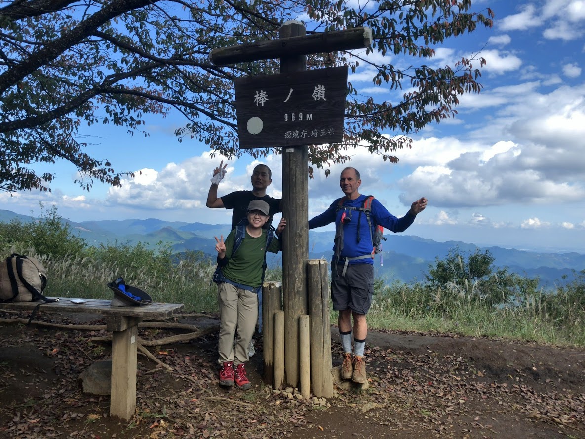
At the border between the Okutama area and the Okumusashi area Mt. Bonore (altitude 969 m).
It is a mountain where a varied trail is impressive, including a walking flow of clear stream through the feet, a mighty valley of Gorj, a walking a rocky walk.
If you want an adventurous trail any longer, I definitely recommend this place.
Hike to Mt.Bōnōre
The second half of the hiking course goes down the beautiful valley called Shirayatani.
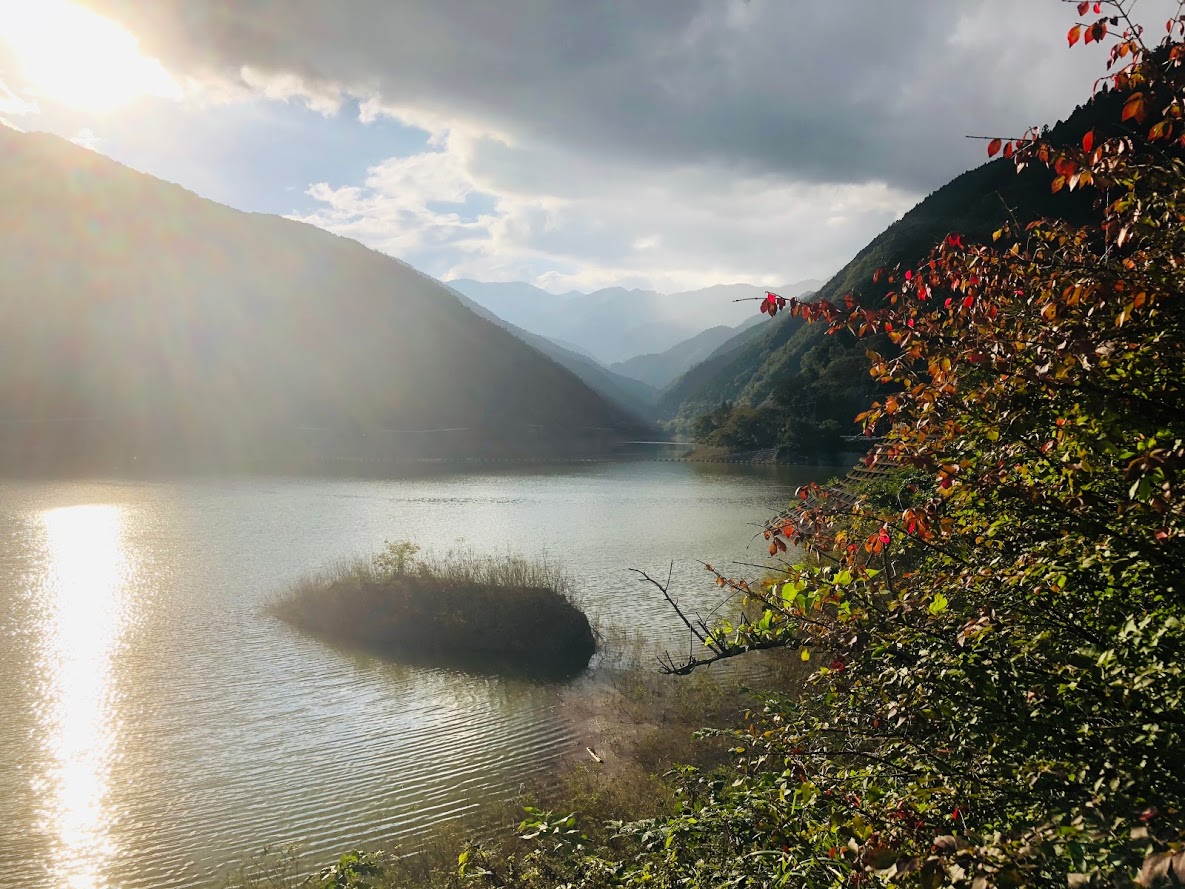
Bonore Mountain’s hiking course includes very beautiful “Shirayasawa valley” and majestic “Arima dam”.
Furthermore, the final destination of this hiking course is a hot spring so you can relax and go home with natural hot water.
Of course it depends on you whether you enter a hot spring or not.
The altitude of Mt. Bounoore is 969 m and it is located at the prefecture border between Tokyo and Saitama prefecture.
The first half of the hiking course starts from about 400 altitudes and climbs this mountain at once.
The second half of the hiking course goes down the beautiful valley called Shirayatani.
From the summit you can see the mountains in Chishibu area. The summit is so wide that it’s perfect for places to have lunch.
When the valley trail is over, you can enjoy magnificent views of the Arima Dam.
Valley is slippery, so let’s go wearing shoes that are hard to slip.
The total walking time is about 4 hours and a half.
If you reach Arima Dam, you will soon reach the spa of goal.
For more information on this hiking route, click here.
Tour details
Price : 1500 yen per person
Distance : 7.42 km
Private Tour (Your family and friends are OK.)
Difficulty : ★★★☆☆
Language : English, Japanese
Meeting place : Hotel pick-up or Kawai Station (depends on your preference)
Meeting time : It is necessary to arrive at Kawai Station at least 9:00 am at least.
Disclaimer
Please read and give me consent before booking for this tour.
Hiking is an inherently dangerous activity that can lead to serious injuries including but not limited to slip and fall injuries, fractures, snake bite, heat exhaustion, poison oak, ticks and frostbite. By participation in this event/hike you agree to not hold these organizers liable for any harm that may come to you, your guests, or your property. Always remember to let the event organizer know if you are leaving the group. Stay on the trail, never hike alone and use your own common sense.
Booking Now
[contact-form-7 id=”4181″ title=”Mt.Bonore Private Hiking Tour in Okutama”]
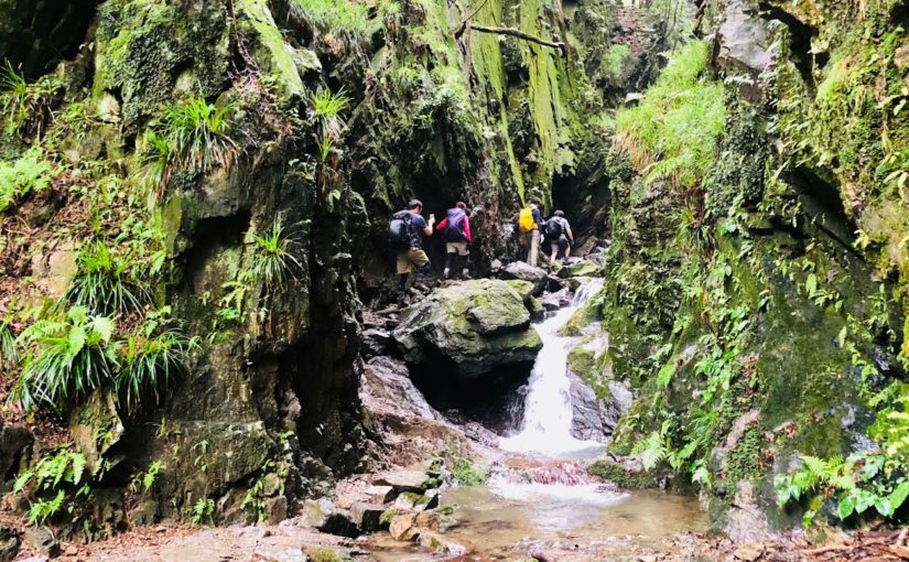
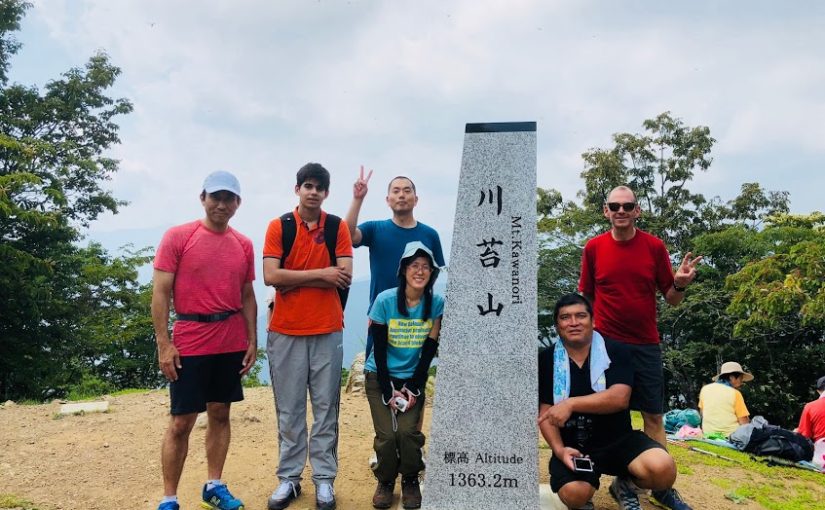
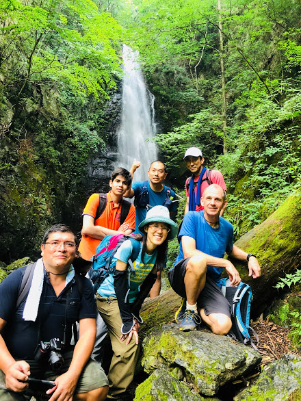
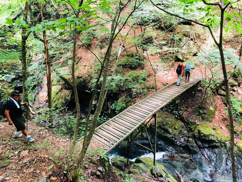
Mt.Kawanori is one of the most popular hiking trails in the Okutama area.
Because you can enjoy a beautiful trail along the valley, a powerful waterfall, and beautiful green trails from the summit to the foot.
If you want to enjoy a varied Japanese hiking style, I recommend this trail.
Hike to Mt.Kawanori
Kawanori Mountain is located at the prefecture border with Saitama Prefecture and is the most popular hiking course in the Okutama area.
This hiking course begins Kawanoribashi bus stop, passes through the summit of Mt.Kawanori, the route arriving at Hatonosu station is so long walking time is 6 hours long trail.
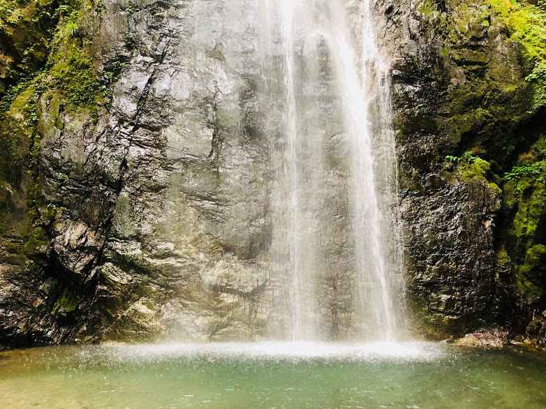
Hyakuhiro Waterfall with a height difference of 40 meters is very powerful, you can enjoy a luxurious small break often in a cool waterfall.
The summit of Mt.Kawanori at an altitude of 1363 m is a spacious square, you can overlook Mt.Kumotori, Mt. Daibosatsurei, Mt.Fuji from there.
There are scattered scenic valleys, hot springs and delicious buckwheat restaurants in the Hatonosu Valley, which is the goal point, so you can take a good rest and relax tiredness of the hiking and return to the hotel.
For more information on this hiking route, click here.
Tour details
Price : 1500 yen per person
Distance : 12.7 km
Private Tour (Your family and friends are OK.)
Difficulty : ★★★☆☆
Language : English, Japanese
Meeting place : Hotel pick-up or Okutama Station (depends on your preference)
Meeting time : It is necessary to arrive at Okutama Station at least 8:25 am at least.
Disclaimer
Please read and give me consent before booking for this tour.
Hiking is an inherently dangerous activity that can lead to serious injuries including but not limited to slip and fall injuries, fractures, snake bite, heat exhaustion, poison oak, ticks and frostbite. By participation in this event/hike you agree to not hold these organizers liable for any harm that may come to you, your guests, or your property. Always remember to let the event organizer know if you are leaving the group. Stay on the trail, never hike alone and use your own common sense.
Booking Now
[contact-form-7 id=”4172″ title=”Mt.Kawanori Private Hiking Tour in Okutama”]


 There are cafes, used outdoor goods stores, convenience stores, etc. along the street.