A Day Hike from Hosawa Waterfall to Sengen Ridge in Tokyo

The hiking course of Sengen ridge (Sengen-one, 浅間尾根) offers beautiful mountain views and Hosawa waterfall. You can access to this trailhead for about 1 hours and a half from Shinjuku station.   This trail was an important road from old times, called Koshu way (甲州道), which connects both countries of Bushu (武州) and Koshu (甲州), in the Edo period was a track for an important life for transporting charcoal. Let’s relax and enjoy hike while thinking of old time people in the clear air which hard to believe you’re still in Tokyo.

You can walk enjoying fine views of such nearby peaks as Mt.Gozen on your right side.

Area: Chichibu-Tama National Park, Hinohara village, Tokyo
Access: Musashi-Itsukaichi Station (武蔵五日市駅) on JR Itsukaichi Line, get off at Hosawa Waterfall Entrance (払沢の滝入口). For more information, click here
Start: Hosawa Waterfall Entrance Bus Stop (払沢の滝入口バス停)
Goal: Henbori Bus Stop (人里バス停)
Difficulty of this trail: ★ ☆ ☆ ☆ ☆
Trail appearance rate: ★ ★ ☆ ☆ ☆
Total distance: 8 km
Total difference in elevation: 661 m
Walking time: 3 hours and 30 minutes
Point of interest: Hosawa Waterfall (particularly in winter), wildflowers (spring to autumn), mountain views, japanese macaque (winter), an Edo-period track for transporting charcoal.

Access to Hosawa Waterfall Entrance (Hosawa-no-taki-Iriguchi, 払沢の滝入口)

Please refer to the following for detailed access method.

In Case of Coming by Car

In Case of Using Train and Bus

Access to Hosawa Waterfall Entrance (Hosawa-no-taki-Iriguchi, 払沢の滝入口)

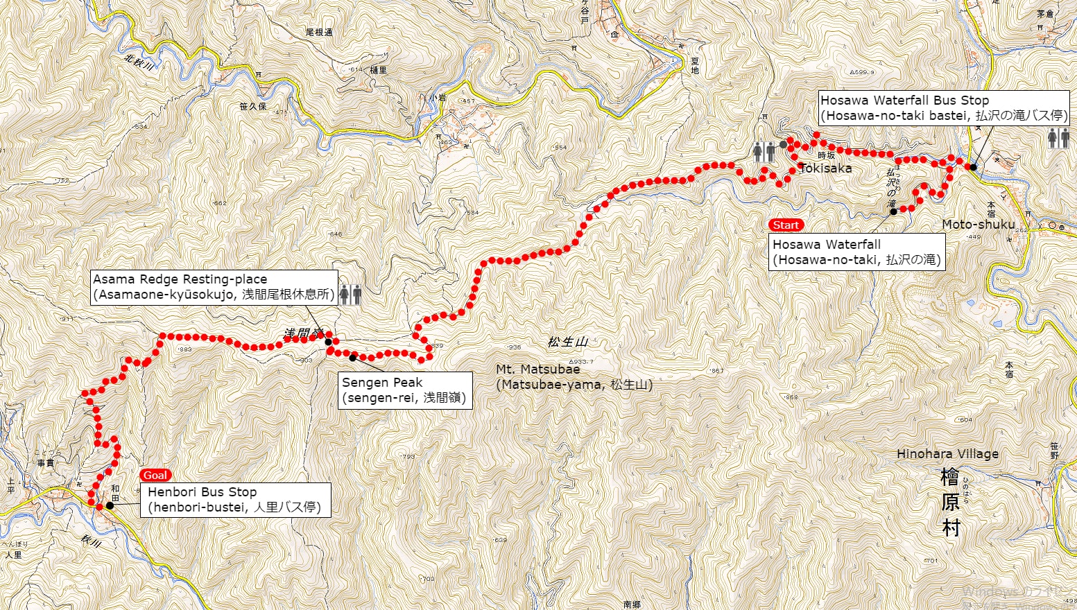
A Map of Sengen Ridge Hiking Route (include Hosawa Waterfall)

A Map of Sengen Ridge Hiking Course | Click on the image above to open the enlarged image in a separate tab.

The source of above the three maps are “Digital Japan Web System” of The Geospatial Information Authority of Japan. The maps were edited a author of this blog.
In Japanese: これらの3枚の地図は国土地理院の電子国土Webシステムから配信されたものをこのブログの著者が加工したものである。

From Hosawa Waterfall Entrance Bus Stop (払沢の滝入口バス停) to Sengen Peak (Sengen-rei, 浅間嶺)

I also recommend popular menu fried donuts and soy milk, both of which are 100 yen at this tofu shop.

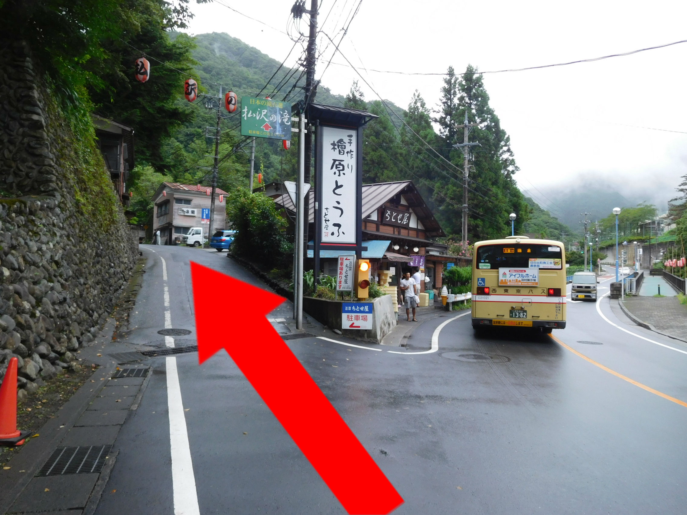
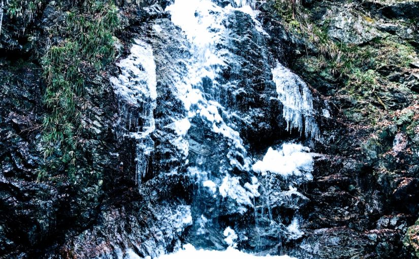
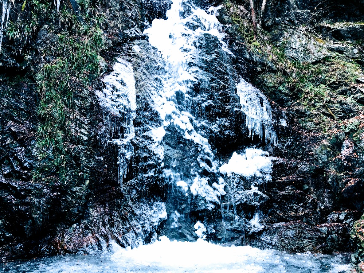
A sign above the road next to left side of the Tofu shop (檜原とうふ ちとせ屋) reads “Hosawa Waterfall” (Howasa no taki, 払沢の滝). Following this sign, go to the narrow road a little bit further on. To get to the waterfall, veer left at a fork a few minutes later onto a dirt path also marked for Hosawa waterfall, though with a simplified first character (払沢の滝). The waterfall is 5-10 minutes along this high rocky path, which crosses several small bridges. In winter, parts of the 60-meter fall and most of the pool at the bottom freeze over, and the icicles hanging off the face make for a splendid sight.

Hosawa Waterfall freezes from late January to early February. This photo above is February 2, 2019.

After visitting the waterfall, return to the previous junction, turn hard left in the direction of Sengen Ridge (Sengen-one, 浅間尾根). This path merges with a dirt road, which you follow uphill to the large bitumen road and bear left. The trail leaves and rejoins this road several times over the next kilometer or so, and passes many old wooden houses.
A few minutes further on, at the sign for “Zizaka Pass, Sengen Peak” (時坂峠 浅間嶺), take the steps up to the left. Rejoin the road 10 minutes later, again heading uphill to the left. The path (similarly signposted) resumes sharply to the left after about 10 more minutes. From here it zigzags up the hill, crossing the road (at a similar sign) after 5 minutes.
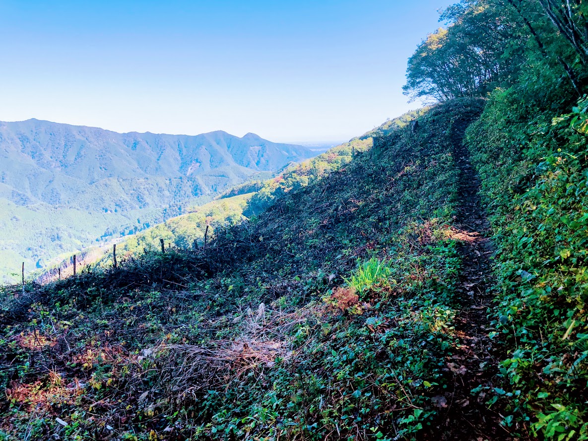
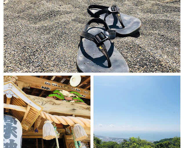
The Path soon bend left (near a tiny shrine), and begins to trace the line of Sengen Ridge, merging with the dirt road that enters from the left after 5-10 minutes.

This farmhouse has been built more than 400 years.

Walking for 7 minutes or so will bring you to a magnificent old farmhouse, rustic sheds, and a water supply system consisting of lengths of bamboo split in half to form open pipes, which are joined together and connected to a nearby stream. This was a soba noodle shop until 2018, but unfortunately closed down now.
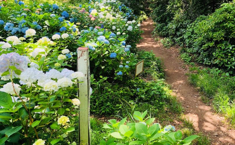
Ascend steeply for 30-40 minutes, first next to small stream and past rock pools, and latter through a forest with broad-leaved magnolia trees (and where orange fungi used in a herbal cancer treatment can be fond). There are also many wildflowers at various times of the year, such as summer yamayuri (gold-banded lily).

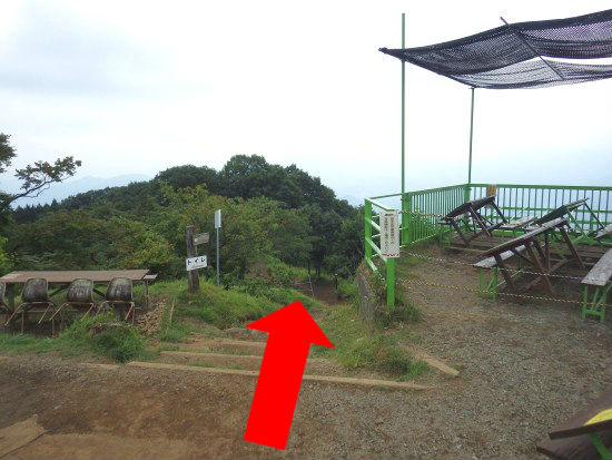
After passing more open area with fine views of such nearby peaks as Mt.Gozen, you come to the junction marked “Observation Deck and Sengen peak” (展望台 浅間嶺) pointing to the left.
Turning left as follow this sign, ascend moderate slope for a while.
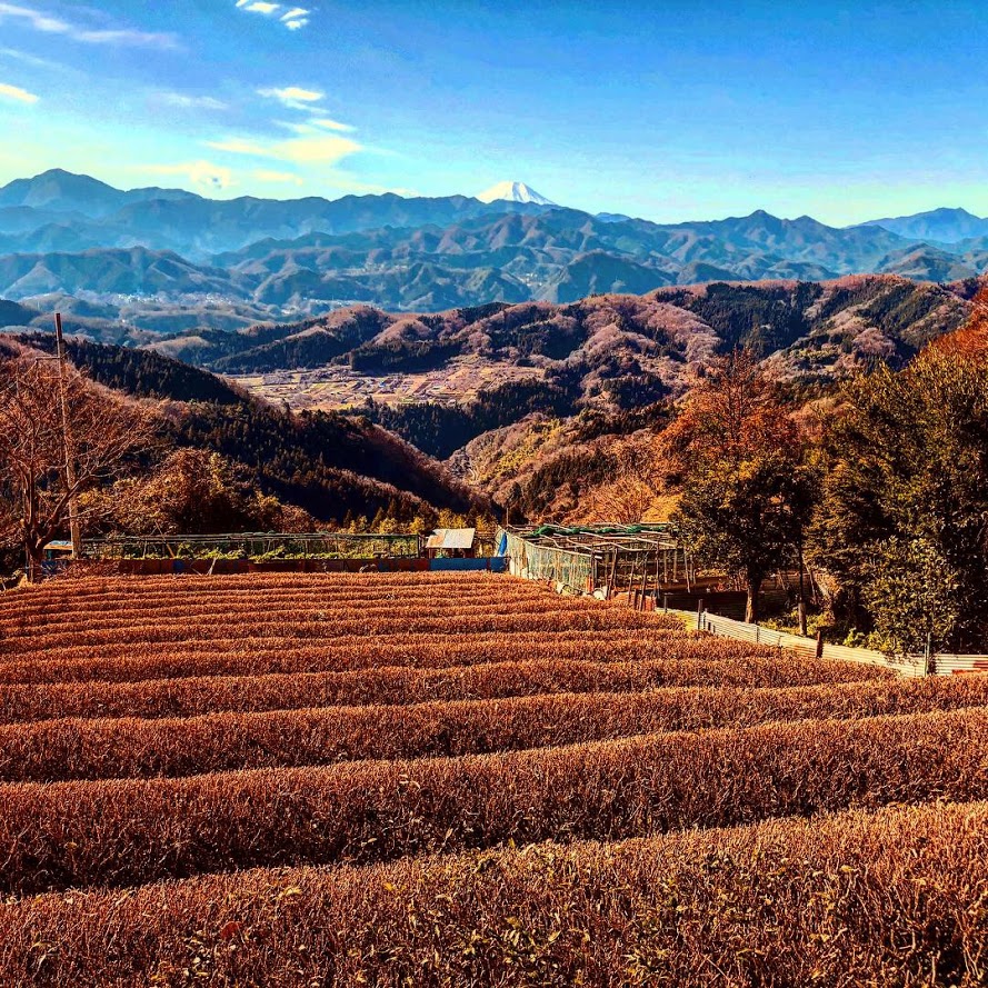
After walking for 10-15 minutes, you arrive at the highest point (904 meters above sea level) on Sengen Ridge. From there, you can enjoy superb views including Mt.Fuji and mountains of Okutama area.
From there, you can enjoy superb views including Mt.Fuji and mountains of Okutama area. Suitable area for lunch is Asama Ridge Resting-Place descending right side from here for approximately 3-5 minutes.
There are picnic area with tables and chairs, a shelter, a fire place, and toilets.

Since snow may be piled up during the winter, let's bring micro crampons. This photo above is February 2, 2019.
Since snow may be piled up during the winter, let’s bring micro crampons. This photo above is February 2, 2019.

The map board provides some history of the area, as follows:

KANTŌ COMMUNITY ROADS
Historical Path
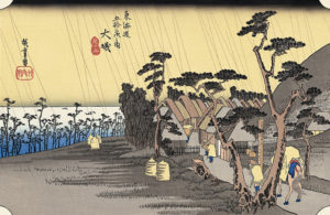
The 8 kilometer route from Kami-Kawanori to Honjuku leads up in the direction of Sengen Ridge and traverses Jizaka Pass. Passing through the middle the Hinohara-mura area and tracing the comparatively moderate lie of the land, Sengen-one Road, also called Naka-Kōshū Road, has form olden times been an important traffic thoroughfare. During the Edo priod, it was an important route for hauling charcoal by horse and for the transport of daily necessities. Besides the village folk, people from Ogouchi and Saihara also used the trail.

Another interesting feature of this area is the presence of the Japanese macaque, which descend in winter from the cold upper reaches of the surrounding mountains to these slopes. They are quite shy and more likely to be sighted on the southern side of the ridge.

From Sengen Peak (浅間嶺) to Hembori Bus Stop (人里バス停)

There is a descend slope on the left side of the map board. After few meters on this slope there are the signposted junction. Turn left as fallow marked “Kazehari-touge and Hembori Bus Stop” (風張峠・人里バス停).
After 5 more minutes you go straight through another T-junction. From here, simply follow the Hembori (人里) signs for about 25 minutes, keeping with an adjacent bamboo stand, to a concrete road near some tea plantations. You take this road down past a few houses to the main road. Hembori bus stop is immediately to your right.

The bus ride to Musashi-Isukaichi Station takes about 45 minutes, and the fare is 820 JPY. To return to Shinjuku Station, in any case follow in reverse the instructions provided in bellow article for this walk.

Access to Hosawa Waterfall Entrance (Hosawa-no-taki-Iriguchi, 払沢の滝入口)


竹の湯 | 麻布十番で東京タワーを眺めながらスイーツラン

真下から眺める東京タワーは迫力満点!
真下から眺める東京タワーは迫力満点!

麻布十番「竹の湯」について

甘味処の名店が立ち並ぶ麻布1丁目の交差点
甘味処の名店が立ち並ぶ麻布1丁目の交差点前

竹の湯は東京メトロ麻布十番駅から歩いて5分の公衆浴場です。
黒美水温泉と呼ばれ、その名の通りコーヒーのような黒褐色のお湯です、
成分は完全に水に溶けているので、沈殿したり体にくっついたりすることはありません。
脱衣所は少々狭く、ランナー用の鍵付きロッカーが4つしかありませんのでご注意ください。
高級レストランや懐石料亭など、大人の夜の街を連想させる麻布ですが、実は甘味処も名店揃いです。
最も有名なのはたい焼き屋さんの浪花家総本店 (なにわやそうほんてん)で、実は名曲「およげたい焼きくん」の舞台となったたい焼きの老舗なんです。
竹の湯を利用して銭湯ランするならこうした甘味処をエイドステーションとして利用するのも面白いかもしれません。

銭湯詳細情報

住所 : 港区南麻布1−15−12

電話:  03-3453-1446

公式サイト: https://takenoyuazabu.wixsite.com/takeno-yu

料金: 460円

休日: 月曜、金曜
営業時間 : 15:00~23:30

アクセス:
東京メトロ南北線「麻布十番」駅下車、1番出口より徒歩5分
都営大江戸線「麻布十番」駅下車、7番出口より徒歩5分

竹の湯の銭湯ランモデルコース

竹の湯から銭湯ランニングするのならばやはり甘味処へ立ち寄ることをお勧めします。
中でも前述の浪花総本家がある麻布一丁目の交差点は甘味の激戦区で、豆源本店、nicoドーナッツ、月島屋の今川焼等、食べ歩きスタイルのお店が多いのも特徴です。
マラソン大会のようにエイドステーションとして利用して、ランニングで失われたエネルギーを補給してみては如何でしょうか?
注意点としては、浪花総本家のたい焼きは大変人気のため予約制になります。
店員さんに名前を告げてだいたい1時間後くらいに出来上がるので、出来上がりの時間に合わせてコースを変更しましょう。
周辺には東京タワーや増上寺、氷川神社や六本木ヒルズなど、見所は沢山あります。

浪花総本家のたい焼き(180円)はしっぽまで餡子が詰まってます。

ランニングの受付方法

ランステーションとしてこの銭湯を利用する場合は下記の手順をご参照ください。

① 靴を靴箱に入れて受付の券売機で460円のチケットを購入し、受付の店員さんに「ランニングで利用したいです。」と伝えましょう。
② 更衣室で着替えて、荷物は更衣室のロッカーに入れましょう。ランナー用の鍵付きロッカーは一番下にあります。
③ 更衣室のロッカーのカギを受付に渡しましょう、ロッカーキーの番号は覚えておくか携帯電話のメモに残しておきましょう。
④ ランニングを楽しみましょう。
⑤ 戻ったら受付に先ほど書いたロッカーキーの番号を伝えて、ロッカーの鍵を受け取ります。
⑥天然温泉でリラックスしましょう。

※ランナー用の鍵付きロッカーは数が4つしかないのでグループランでご利用の場合は人数にご注意ください!

Guide for Hiking Trail of Mt. Jimba

New Year's Eve of 2018 with my hiker's friends at a restaurant on the top of the Mt. Jimba.
New Year’s Eve of 2018 with my hiker’s friends at a restaurant on the top of the Mt. Jimba. You can see Mt. Fuji on our background.

Area: Hachiōji city, Tokyo, Japan
Access: Fujino Station (Fujino-eki, 藤野駅) on the Chūō Main Line of East Japan Railway Company, board a bus bound for Wada (和田)  for 5 minutes, get off at Jimba trailhead (Jimba-tozanguchi, 陣馬登山口)
Start: Jimba trailhead bus station (Jimba-tozanguchi, 陣馬登山口)
Goal: Jimba trailhead bus station (Jimba-tozanguchi, 陣馬登山口)
Difficulty of this trail: ★ ☆ ☆ ☆ ☆
Trail appearance rate: ★ ★ ★ ☆ ☆
Total distance: 9 km
Total difference in elevation: 661 m
Walking time: 4 hours and 40 minutes
Point of interest: Good views of surrounding mountains (including Mt. Fuji and the Knatō Plain) , a bowl of soba noodles at restaurants of the summit, mountain village, hot spring, Japanese macaque (in winter).

Access to Jimba trailhead bus station (Jimba-tozanguchi, 陣馬登山口)

Please refer to the following for detailed access method.

In Case of Coming by Car

In Case of Using Train and Bus

A Map of Mt. Jimba Hiking Route

A Map of Mt. Jimba Hiking Course | Click on the image above to open the enlarged image in a separate tab.

The source of above the three maps are “Digital Japan Web System” of The Geospatial Information Authority of Japan. The maps were edited a author of this blog.
In Japanese: これらの3枚の地図は国土地理院の電子国土Webシステムから配信されたものをこのブログの著者が加工したものである。

From Jimba trailhead bus station (Jimba-tozanguchi, 陣馬登山口) to the Top of Mt. Jimba (Jimba-sanchō, 陣馬山山頂)

Walk along the road in the same direction as the bus wast traveling. You can find a sign beside a stone monument signposted “Mt. Jimba via Ichino Ridge” (一ノ尾根経由陣馬山) on the right side as you go about 100 meters.

Turn right at the sign written "Mt. Jimba via Ichino Ridge" (一ノ尾根経由陣馬山).
Turn right at the sign written “Mt. Jimba via Ichino Ridge” (一ノ尾根経由陣馬山).

As soon as you turn right at the T-junction as follow of the sign, you can see a sign in front of post office signposted “Mt. Jimba 100 minutes Ichino Ridge Course” (陣馬山 100分 一ノ尾根コース) .

Turn left at the sign written "Jimba 100 minutes Ichino Ridge course" (陣馬山 100分 一ノ尾根コース).
Turn left at the sign written “Jimba 100 minutes Ichino Ridge course” (陣馬山 100分 一ノ尾根コース).

Follow the signboard and turn left, the path ascend from here. After ascend slope for about 20 minutes you will see a sign written “Mt. Jimba 4.0 km”. This sign is the trailhead of Mt. Jimba and after that the path become dirt trail. After turning to the left according to the direction of signboard, the trail though the beautiful ceder forest in about 1 hour and a half.

the beautiful ceder forest

When you ascend the steep staircase, there is the mountain peak of Mt.Jimba. You can see 360-degree awesome panorama view include Mt.fuji and Kanto plain, Sagami Bay from here.

This place might be a best place to have a lunch, because there are three restaurants and hiking tables and benches on the summit of Mt.Jimba. Those shops offer some snacks and beverages including alcohol. Personally, I think the most delicious meal in those restaurants is a soba noodle with various vegetables and mushrooms (Jimba-soba, 陣馬そば) at Shimizu Tea-shop(Shimizu-jaya, 清水茶屋).

A soba noodle with various vegetables and mushrooms (Jimba-soba, 陣馬そば) 600 JPY

From the Top of Mt. Jimba (Jimba-sanchō, 陣馬山山頂) to Jimba trailhead bus station (Jimba-tozanguchi, 陣馬登山口)

The way to Jimba trail head bus station goes via Tochitani Ridge (Tochitani-one, 栃谷尾根). But there are no signposted Tochitani Ridge (Tochitani-one, 栃谷尾根) on this area. The way to return is on the left side path of the Fujimi Restaurant (Fujimi-chaya, 富士見茶屋) which is the most highest place restaurant on the summit.

Note that there are no signposted "Tochitani Ridge" (栃谷尾根) which is our return way on top of Mt.Jimba.
Note that there are no signposted “Tochitani Ridge” (栃谷尾根) which is our return way on top of Mt.Jimba.

If you down stairs beside Fujimi restaurant, there is a signboard written “Tochi-tani 2.7 km” (栃谷 2.7 km) ahead 100 meters from the restaurant, you can go to Tochitani Ridge as follow this sign.

Ignore paths branching off to the left side, a little farther on. There is a new branch and then veer right side path at this branch as follow signposted “Tochitani Ridge and Jimba Trailhead Bus Stop” (栃谷尾根 陣馬登山口バス停).

A steep descent leads down to cedar and cypress forest. There are the most steep slope in this hiking course, let’s walk slowly with attention to slips and falls.
After 1 hour and 20 minutes or so, you reach Tochitani village, you can see tea plantations and yuzu plantation against superb view of Mt. Fuji. If it’s winter, you can buy sweet smell yuzu at the roadside stand.

Tochitani (栃谷) is a relaxing village with tea fields and Yuzu fields.

Go through the path in the village. After a while there is a place named “Tochitani Park Restroom” (栃谷園地休息所) with a bath room and a table and chairs. You can wash your boots in the tap with a brush.
Just over 5 minutes leaving “Tochitani Park Restroom”, at a brunch signposted 陣屋温泉 where the path to the left to Jinya Hot Spring (Jinya-onsen, 陣屋温泉). If you visit the hot spring, bathing fee is just 1000 JPY.

You can enjoy a Japanese cypress wood bathtub at Jinya hot spring. I recommend to carry a towel.
You can enjoy a Japanese cypress wood bathtub at Jinya hot Spring. I recommend to carry a towel.

In 20-30 minutes, after passing the previous branch signposted hot spring, you can find a post office which you saw in this morning. You are a bus stop soon if you turn left at the T – junction ahead and go about 100 meters.

Note: The bus on the way back are very few numbers.
Even if there is no convenient bus, it is about 20 minutes on your foots to back Fujino station.
The timetable of returning bus is here.


Access to Jimba trailhead bus station (Jimba-tozanguchi, 陣馬登山口)

In Case of Coming by Car

There are no parking lots around Jinba Trailhead Bus Station (Jinbatozanguchi-bustei, 陣馬登山口バス停).
If you come by car there is a parking lot around Fujino station.
The following is the pay parking lot closest to the Fujino station.

Google Map of a parking lot around Fujino station

From Fujino (藤野) station station to Jimba trailhead bus station (Jimba-tozanguchi, 陣馬登山口)

Leave the station by the only exit, and down stair, walk slightly to the right to Bus Stand outside, and board a bus bound for Wada (和田).
After about 5 minutes, get off at Jimba trailhead bus station (Jimba-tozanguchi, 陣馬登山口). The fare is 180JPY.

In Case of Using Train and Bus

From JR Shinjuku (新宿) station to Fujino (藤野) station

From JR Shinjuku station, take a Chūō Line (中央線) ordinary train (futsū, 普通), bound for Ōtsuki (大月)  or Kōfu (甲府), to Fujino (藤野) station. These leave from Platform 7, 9, or 10, depending on the time. Take care not to board the more luxurious long-distance trains, which levy a surcharge and do not stop at Fujino.
If the departure times are inconvenient, catch the special rapid train (tokubetsu kaisoku, 特別快速) or rapid service train (kaisoku, 快速) from Platform 10 to Tachikawa (立川), Hachiōji (八王子), or Takao (高尾) station (trains with Takao as their destination have the most frequent connections), and transfer, since some trains that are suitable originate from here bound for Ōtsuki, Kōfu, Kobuchizawa (小淵沢), and Matsumoto (松本).
The fare is from Shinjuku to Fujino is 972JPY, and the journey takes 1 hour and 25-40 minutes (excluding connecting time).

Please check the latest timetable, because the timetable and fare are sometimes changed.
Timetable and Route Serch “HyperDia”
http://www.hyperdia.com/sp/index.html.en

There are two bus stops, but on the far side of the right.

Leave the station by the only exit, and down stair, walk slightly to the right to Bus Stand outside, and board a bus bound for Wada (和田).
After about 5 minutes, get off at Jimba trailhead bus station (Jimba-tozanguchi, 陣馬登山口). The fare is 180JPY.

Note: The bus going are very few numbers.
Even if there is no convenient bus, it is about 20 minutes on your foots to go Jimba trailhead bus station.
The timetable of going bus is here.

Google Map of Jinbatozanguchi Bus Stop

In Case of Walking from Fujino Station to Jinbatozanguchi Bus Stop on foot

Leave by the only exit at Fujino Station and turn left in the direction marked “Mt.Jimba on foot” along rail way.
Some 3-5 minutes walk the road along the rail way, turn left and cross the railroadcrossing.
A little bit farther on there is a tunnel and go through out the tunnel and less than 15-20 minutes away is the bus the Jinbatozanguchi bus stop.

From Jinbatozanguchi Bus Stop go straight ahead and this stone monument is.

Private Hiking Guide to Miura Reef Route | Seaside Stroll Along Beautiful Rocky Coast in Miura Peninsula

Miura Reef Route is a day walking route along the coast in Miura City, Kanagawa Prefecture, located south of Tokyo.
The rock is scraped by wave and wind to entertain beautiful and strange landscape.
It is also a wonderful hiking route where you can taste the caves that the ancients lived in the Yayoi period and delicious seafood.
Especially in the winter it is recommended because the air is clear and the adjacent Bōsō Peninsula is clearly visible.

There are roads that submerge at high tide.

Tour details

Price : 3500 JPY per person

Distance : 10.3 km

Private Tour (Your family and friends are OK.)

Difficulty : ★☆☆☆☆

Language : English, Japanese

Meeting point : Miura-kaigan Station or Tokyo station.
The exact meeting point will be set by your guide after booking confirmation, but I respond flexibly according to your area of accommodation. Transportation to the start point is not included in the tour price.

Meeting time : negotiable

What you can experience at this Course :

Dwellings of the Yayoi people (from the 10th century BC to the 3rd century AD)

・Cape Tsurugi Lighthouse
・Beautifully strange rock art
・Nusuto-gari (A Deep cliff name)
・Caves
・Seaweed Cultivation
・Delicious Tuna with Tuna Bowl

Nusutogari (盗人狩)
Nusutogari (盗人狩)

With this hiking you can pass through a number of Japanese fishing ports in the country and you can also taste the local food of the fishing port.
Do not you relax, escaping from the hustle and bustle of the city, with the voice of the gulls and the sound of the waves and the walking path of the quiet rocks that can not be experienced?

Lunch set menu (Tuna with Tuna Bowll) 1200JPY

For more information on this hiking course, click here.

Disclaimer

Please read and give me consent before booking for this tour.

Hiking is an inherently dangerous activity that can lead to serious injuries including but not limited to slip and fall injuries, fractures, snake bite, heat exhaustion, poison oak, ticks and frostbite. By participation in this event you agree to not hold these organizers liable for any harm that may come to you, your guests, or your property. Always remember to let the event organizer know if you are leaving the group. Stay on the trail, never walk alone and use your own common sense.

Booking Now

[contact-form-7 id=”4438″ title=”Private Hiking Guide to Miura Reef Route”]

Mt.Koma Private Trail Running Tour in Ōiso

If you want to enjoy the beach and the mountain at the same time, this course is recommended.
At Mt.Koma of Ōiso arriving at Tokyo Station from less than an hour by train, you can enjoy 360 ° panorama overlooking Mt.Fuji and you can play at the beautiful beach at the end of the trail.

Hike to Mt.Koma

The 360-degree view from “Shounandai” is really wonderful overlooking Mt. Fuji, the Boso Peninsula and the mountains of Tanzawa.

When you head towards Shonan from Tokyo direction, it is a mountain 165 meters above sea level, located on the east side of Shonandaira which is the green field of Oiso that you can see from the train first.
That is Mt.Koma.
Until the end of the Edo period, this mountain was protected as a spiritual area of the Koma Temple and logging of trees was forbidden, so the rich forest is still protected today.

There is a quiet and peaceful trail surrounded by woods, resting places are dotted in some places.

The Koma Mountain park nature trail has been selected as “Japan’s Forest 100” selected by the Japan Forest Instructor Association, you can observe the original nature of nature.
This trail is a forested area formed by various trees, and you can also see rare fields, wild birds and butterflies in the Mt.Asama area (north of the route along the ridge).

Ōiso Beach
Ōiso Beach was the first Japanese beach in Japan that was established in 18th Meiji era. It is a popular spot for families and couples. Moreover, it is around 10 minutes even if you walk from JR Oiso station. Shower is also installed, so let’s bring swimsuit and enjoy the swimming!

For more information on this trail running route, click here.

Tour details

Price : 1500 yen per person

Distance : 5.7 km

Private Tour (Your family and friends are OK.)

Difficulty : ★☆☆☆☆

Language : English, Japanese

Meeting place : Hotel pick-up or Ōiso Station (depends on your preference)

Meeting time : negotiable

Disclaimer

Please read and give me consent before booking for this tour.

Trail running is an inherently dangerous activity that can lead to serious injuries including but not limited to slip and fall injuries, fractures, snake bite, heat exhaustion, poison oak, ticks and frostbite. By participation in this event/hike you agree to not hold these organizers liable for any harm that may come to you, your guests, or your property. Always remember to let the event organizer know if you are leaving the group. Stay on the trail, never hike alone and use your own common sense.

Booking Now

[contact-form-7 id=”4431″ title=”Easy Trail Running to Mt.Koma in Oiso | Let’s enjoy both Hiking and the Beach in 1 day!”]

Easy Trail Running to Mt.Koma in Oiso | Let’s enjoy both Hiking and the Beach in 1 day!

Do you like sea, or do you like mountains?
If you want a trail running that enjoys both mountains and oceans near Tokyo, I recommend Mt.Koma in Oiso.
If you use the JR Shonan Shinjuku line to Oiso station you will arrive in about 1 hour from Shinjuku, the scenery you see from Mt.Koma crossing Oiso town and Hiratsuka city is a magnificent view, you can see Enoshima island and Mt.Fuji.
In the trail of about 5.7 km in length, you can enjoy trees unique to warm regions, and even after trail running you can swim at the beach at the beach.

JR Oiso station
JR Ooiso station
Oiso station is the station of JR The Tōkaidō Main Line in Kanagawa prefecture, there is “Oiso beach” near the station so if you bring swimsuit in the summer you can enjoy the swimming.

Mt.Koma nature trail

When you arrive at Oiso station, go right along the railway track, pass through under the guardrail and go up the Slope and you will find Takada Park, and the trail will start from the right back of this park.

The view from Takada Park is also wonderful.

Mountain trail to Mt.Koma

The trees live in warm areas such as evergreen trees and “Litsea coreana”, and it is a beautiful natural road.

You can enjoy a hydrangea trail in June.

A radio tower of Shonandaira

As you climb a gentle slope, you will see a radio tower on the left.
It is the ridgeline of “Shounandaira” and “Mt. Koma”, and turning to the left is “Shounandaira”.

View from Shonandai


The 360-degree view from “Shounandai” is really wonderful overlooking Mt. Fuji, the Boso Peninsula and the mountains of Tanzawa.
“Shonandai” has a restaurant, you can enjoy fish cuisine caught locally while looking at magnificent scenery.

The sumitt of Mt.Asama

It goes via ‘Mt. Asama’ with big tree of enoki and shrine.

There is a quiet and peaceful trail surrounded by woods, resting places are dotted in some places.

The sumitt of Mt.Koma

There is no prospect of the mountaintop of Mt. Koma, but there is a mysterious atmosphere with remains of an ancient castle wall.

Takaku Shrine
Takaku Shrine

Torii of Takaku Shrine
It is a shrine founded in 717.
In the Kamakura period there were 24 temples in the mountains of Mt.Koma rising behind the temple.
Until the end of the Edo era the whole mountain was protected as a spiritual area of Temple.

Pine trees

From the “Takaku Shrine”, when entering the national highway, rows of trees of pine and enoki are lining up. This area is famous as “Old Tokaido” continued to Osaka in the Edo period, and it is also the stage of Hiroshige’s “Oiso Toragaame” famous for “Ukiyo-e”.
Oiso Toragaame

Oiso Beach

It was the first Japanese beach in Japan that was established in 18th Meiji era.
It is a popular spot for families and couples. Moreover, it is around 10 minutes even if you walk from JR Oiso station.
Shower is also installed, so let’s bring swimsuit and enjoy the swimming!

If you are looking for tour guide of this trail running course please refer to the following.

Mt.Koma Private Hiking Tour in Ōiso

銭湯ランニング入門

銭湯ランニングとは?

銭湯ランニングとは公衆浴場である「銭湯」を利用してランニングする方法です。
ランナーは荷物を更衣室のロッカーに預け、ランニングウェアに着替えて手ぶらで(もしくはスマートフォンとお財布だけ持って)ランニングを楽しむことが出来ます。
もちろんランニング後はシャワーを浴びて湯舟でリラックスすることが出来ます。
銭湯施設を利用してランニングを楽しむランナーを一般的に銭湯ランナーと呼びます。

銭湯ランが出来る銭湯は?

現在日本には約4000軒ほどの銭湯が営業していて、サウナや天然温泉、食事処やカラオケなどそれぞれ独自のサービスを提供しています。
残念ながらその全ての店舗で銭湯ランのサービスが利用できるわけではありません。
私の住む東京には約500軒ほどの銭湯が営業しており(2019年現在)、その中の約100軒弱の銭湯で銭湯ランのサービスを実施しています。
ランニング利用が出来る銭湯は公式HPなどに「荷物の一時預かり」と表記されています。
この表記がされている銭湯ではロッカーに自分の荷物を預けて、外出する(=ランニング)事が可能です。

荷物一時預かりを利用できる銭湯施設は下記のサイトが便利です。

東京銭湯マップ
http://www.1010.or.jp/map/archives/meta/luggage
私のほうでも今後、具体的な店舗情報は随時このブログに更新していく予定です、ご興味ございましたらフォローよろしくお願いいたします。

銭湯ランの料金は?

銭湯をランニング利用するのに追加料金は発生しません。
つまり無料です。
ランナーは銭湯の入浴料金を支払って銭湯ランを楽しむことが出来ます。
銭湯の入浴料金はお住まいの都道府県によって違います。
私の住む東京では一律460円です。
詳しくは下記の「全国浴場組合HP」をご参照ください。
http://www.1010.or.jp/zenyoku/fee.php

銭湯ランの利用方法は?

銭湯をランニング利用する方法は各施設によってマチマチですが概ね下記の流れとなります。
① 靴を脱いでロッカーに預ける。
② 受付で料金を支払い「ランニングで利用したい」旨を伝える。
③ 更衣室でランニングウェアに着替えてロッカーに荷物を預ける。
④ 受付にロッカーキーを預けてランニングに出かける。
⑤ ランニングから戻ったら受付でロッカーキーを受け取る。
⑥ シャワーでキレイに体を洗って入浴する。
施設によって微妙にルールが違ったりするので、今後私のほうでアップロードしていく予定の個々の店舗レポートをご参照ください。

銭湯ランの注意点

銭湯ランニングする際は以下にご注意ください。

① 湯舟に入る前は体をしっかり洗いましょう。

当たり前の話で恐縮ですが、銭湯によってはシャンプーやボディーソープが設置されていない施設があります。
予め公式HPなどを調べて、無い場合は受付で有料の入浴セットを購入するか持参しましょう。

② 利用時間を守りましょう。

施設によってはランニングで外出時間が制限されている場合があります。

③ ランニングシューズについて

施設によって更衣室にランニングシーズを持ち込めない場合があります。
その場合は多くの施設で入り口にランニングシーズ専用の靴置き場が設置されていますのでご利用ください。(その場合は受付で店員さんより説明があると思いますのでご安心ください。)

銭湯ランナー募集

下記は私Tokyo Sampo Masterの主催する銭湯ランニンググループです、月一回東京都内のどこかの銭湯でゆる~い無料ランニングイベントを実施しています。
年会費等はございませんので、銭湯ランニングにご興味が御座いましたらフォローだけでも宜しくお願いいたします。

東京銭湯ラングループ

Peatix(ピーテックス)
https://peatix.com/group/2043407/view#

MeetUp(ミートアップ)
https://www.meetup.com/ja-JP/%E6%9D%B1%E4%BA%AC%E9%83%BD-%E3%83%A9%E3%83%B3%E3%83%8B%E3%83%B3%E3%82%B0-Meetup/

Private Trail Running Tour in Kamakura Daibutsu Hiking Course

If you visit “Great Buddha of Kamakura” of “Kotokuin Temple”, we recommend you to choose running course.
“Kamakura’s Daibutsu Hiking Trail” starting from Kitakamakura Station is a 3 kilometer-long trail that includes a historic temples and shrines, a beautiful forest and a stylish cafe in the forest.
Of course the goal is “Kotokuin Temple” with “Great Buddha of Kamakura”.

Tour details

Price : 1500 yen per person

Distance : 3 km

Private Tour (Your family and friends are OK.)

Difficulty : ★☆☆☆☆

Language : English, Japanese

Meeting place : Hotel pick-up or Kita-Kamakura Station (depends on your preference)

Meeting time : negotiable

Trail Running to Kamakura Daibutsu Hiking Course

Jouchiji Temple
The green lush Jochiji Temple wrapped in silence designated as a national historic site is the starting point of Kamakura Daibutsu Hiking Course.

In this course you will first leave from Kitakamakura station and you will explore the famous Tokeiji Temple at Engakuji Temple, the second largest Kamakura Gozan temples.
After that you will climb the mountain trail of “kuzuharagaoka hiking course” from Jochiji Temple, wash your coin with “Zeniarai Benten Shrine”, then walk “Daibutsu Hikingu Course” to “Great Buddha of Kamakura”.
In the end you visit the “Hasedera Temple”, Enoshima Electric Railway Hase Station is the goal.
It is a course of about 3 km in length.

Most of the trails are dirt trails, I recommend walking easy sneakers or mountaineering shoes.

Flowers are Tokeiji Temple plum in February and March, Cherry blossoms of Kuzuharagaoka in April, Trail of fresh green in May, Hydrangea of Tokeiji Temple in June, Bodhi tree in the bellflower of Jochiji Temple in July, autumn leaves .
You can enjoy various flowers almost all year long.

There are Hasedera Temple and various sights and restaurants around Hase Station.

For more information on this trail running course, click here.

Disclaimer

Please read and give me consent before booking for this tour.

Trail running is an inherently dangerous activity that can lead to serious injuries including but not limited to slip and fall injuries, fractures, snake bite, heat exhaustion, poison oak, ticks and frostbite. By participation in this event/hike you agree to not hold these organizers liable for any harm that may come to you, your guests, or your property. Always remember to let the event organizer know if you are leaving the group. Stay on the trail, never hike alone and use your own common sense.

Booking Now

[contact-form-7 id=”4419″ title=”Private Trail Running tour in Kamakura Daibutsu Hiking Course”]

Trail Running to Kamakura Diabutu(Great Buddha) Hiking Course

Daibutsu Hiking Course is a trail packed with highlights that connects ‘Jouchiji Temple of Kitakamikura’ and the symbol of Kamakura ‘Great Buddha’ which stands on the grounds of Kotokuin Temple.

It is a course with a great relief and a running distance of about 3 km in total length. Please avoid leather shoes and heels.
This trail which is representative of Kamakura very popular from trail running beginners to advanced people.

If you have plenty of time you can enter the hot spring in the ocean view and relax and return home.

Kamakura is a popular tourist destination to arrive in about 1 hour from Shinjuku. You can see lots of old shrines, temples and Japanese garden and enjoy various types of Japanese restaurants.

JR Yokosuka Line “Kitakamakura station”
JR Yokosuka Line "Kitakamakura station"

area:
Kanagawa Prefecture South of Tokyo
Genre:
Trail Running
LEVEL:
Beginner
Traveling time (not including breaks):
3 hours 30 minutes
Distance:
About 8km
Maximum elevation difference:
100m
Access:
JR Yokosuka Line「北鎌倉駅 Kitakamakura  station」
 Return:
Enoshima-dentetu  Line「稲村ケ崎駅 Inamuragasaki  station」


※It is an outline of the approximate course, please note that it is not completely correct guidance.

There is a map of today’s course in front of the station.
a map of Hikking trails

Leave the station and turn to the left.
the Road in front of the KItakamakura staition

It goes through several temples by Jouchiji Temple for the purpose.
Gate of Toukeiji Tenple

Turn right at this sign.
sign

Jouchiji Temple is more attractive than nature’s famous Zen temple, nature is deep and wild
Jouchiji Temple

Admission fee 200 yen.Jouchiji Temple

Continue along the bamboo stuff on the side of Jodiji Temple.
the bamboo stuff on the side of Jodiji Temple

It turns into a mountain path from this neighborhood.
entrance of Daibutsu Hiking Trail

a mountain path

Probably it is a squirrel on the way of the trail, if you hear strange cries from the trees.
Daibutu Hikking trail

I will arrive at the Kuzuhara shrine after going on a steep slope for a while.
sighn of Daibutu Hikking trail

a pond of Kuzuharaoka Temple

Kuzuharaoka Temple
Aizuchiinari Temple
Kuzuharaoka Temple

In the park adjacent to the shrine, a bench is set up and it is ideal for taking a break.
In the park adjacent to the shrine

It is a view which can see the city of Kamakura.
the city of Kamakura view

Nearby there is a grave of Toshimoto Hino which is a god of Kuzuhara Oka Shrine.
a grave of Toshimoto Hino

Let’s follow the signs of Daibutu Hiking Course (大仏ハイキングコース).
the signs of Daibutu Hiking Course

It is a luxurious view with sea view.
sea view

There is a cafe “Ituki” on the trail.
a cafe "Ituki"a cafe "Ituki"
Daibutu Hiking trail

Koutokuin which there is a great Buddha is 400 meters away.
Daibutu Hiking trail

As you get off the stairs you have a tunnel so please go down the slope without going to the tunnel side.
the end of the Daibutu Hiking trail

Kotokuin entrance fee is 200 yen.
Kotokuin entrance
Kamakura Daibutu

It is a famous Kamakura Great Buddha.
Kamakura Daibutu

You can enter the inside of the Great Buddha with an admission fee of 20 yen.
the inside of the Great Buddha

the Great Buddha

There are many restaurants and souvenir shops around Kotokuin.
souvenir shop

Kamakura gelato is a popular gelato shop.
Kamakura gelatoKamakura gelatoTriple gelato is 520 yen.Kamakura gelato

Hase Temple is called the western paradore of Kamakura, a Hase-ji temple that is popular as a “flower temple” throughout the year.Hase Temple
the garden of Hase Temple
flowers of the Hase Temple
the Hase Temple
the Hase Temple
the Hase Temple
japanese garden of the Hase Temple
Cute jizo

Hydrangea was beginning to bloom at this time.
Hydrangea
Senju kannon
Hase Temple
Hase Temple
Cave of Hase Temple
Cave of Hase Temple

It is said that it will come true if you write a wish in an ema.
ema

You can also enjoy a beautiful Japanese garden.
beautiful Japanese garden of Hase Temple
Kresannsui is a garden style that expresses the landscape of mountain water with stones, sand, etc. without using water such as pond and sewage.
beautiful Japanese garden of Hase Temple

Next to Hase Sta. There is “Haseka Shokudo”.
Haseka Shokudo

We will have beer at “Hase Shokudou”.
beer at "Hase Shokudou".
Raw Shirasu bowls will be served at soy sauce.
Raw Shirasu bowls

You are going to the sea in a few minutes from Hase Sta.
Yuigahama Beach

Let’s go to the seaside (to the right) and go to the hot spring if you have time!
Yuigahama Beach

The first floor of Inamuragasaki Onsen is a restaurant.Inamuragasaki Onsen

Let’s relax at the hot spring in the ocean view.
hot spring in the ocean view

Enoshima Dentetsu Railway “Inamura Gasaki Station”Inamura Gasaki Station

If you are looking for tour guide of this trail running course please refer to the following.

Private Trail Running Tour in Kamakura Daibutsu Hiking Course