【Introduction】
Hello!
I am a native Japanese living in Tokyo.
I introduce hiking trails and running spots in Tokyo for those traveling to Tokyo under the name of "Tokyo Sampomaster".
blog : https://sampomaster.com
twitter : https://twitter.com/Sampomaster1
YouTube : https://www.youtube.com/channel/UC38T5PQ3bUZ8aC3qAScvuTQ
【Hiking trail】
Although it is not well known, there are many mountains that are suitable for hiking in Tokyo.
If you are staying in Tokyo for a week, why not try going to the countryside near Tokyo for one day?
A beautiful valley, an old shrine and a relaxing hot spring will heal you and will surely be unforgettable memories.
【Running spots】
If you are a runner, why do not you visit the sightseeing areas of Tokyo by running?
There are many facilities equipped with shower and hot spring for runners in Tokyo.
The experience of running through the Imperial Palace, traditional temples and shrines with your own feet is a wonderful memory that you can not change anything.
If you do not mind, I will undertake free guides as well.
English is still not very good, but I will try my best so please feel free to contact us!
info@sampomaster.com
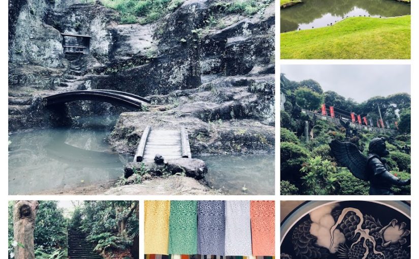
How about Kamakura trail running for only 1 hour by train from Tokyo?
Once serving as a holy trail for Shugendou priests, the Kamakura’s Tenen Hiking Trail along the so-called Kamakura Alps with its highest point Ohhirayama, 159.2meters(about 522 feet) above sea level, is the most popular hiking trail in Kamakura.
Hiker will be able to enjoy a view of Sagami Bay and Mt.Fuji, and visit cave tombs and other historic spots along the trail that about 5.5 kilometers or 3.4 miles stretching from Imaizumidai to Zuisenji.
This running route is accessible from several point: Hansobo 半蔵坊 on the premises of the Kenchoji Tenple(an admission fee of 300yen required to enter the tenple), the trail exit near Zuisenji.
It will take two to three hours to enjoy the trail.
Kamakura’s Tenen Trail ~ Okuzashiki of Kencho-ji Temple, To Hansobou
Here we will guide the trail in the direction heading from the Kenchoji Tenple to the Zuisenji Temple in kamakura.
First off is Kitakamakura station(East Entrance)
area:
Kanagawa Prefecture South of Tokyo
Genre:
Trail Running
LEVEL:
Beginner
Traveling time (not including breaks):
2 hours 30 minutes
Distance:
About 7km
Maximum elevation difference:
100m
Access:
JR Yokosuka Line「北鎌倉駅 Kitakamakura station」
Return:
JR Yokosuka Line「鎌倉駅 Kamakura station」
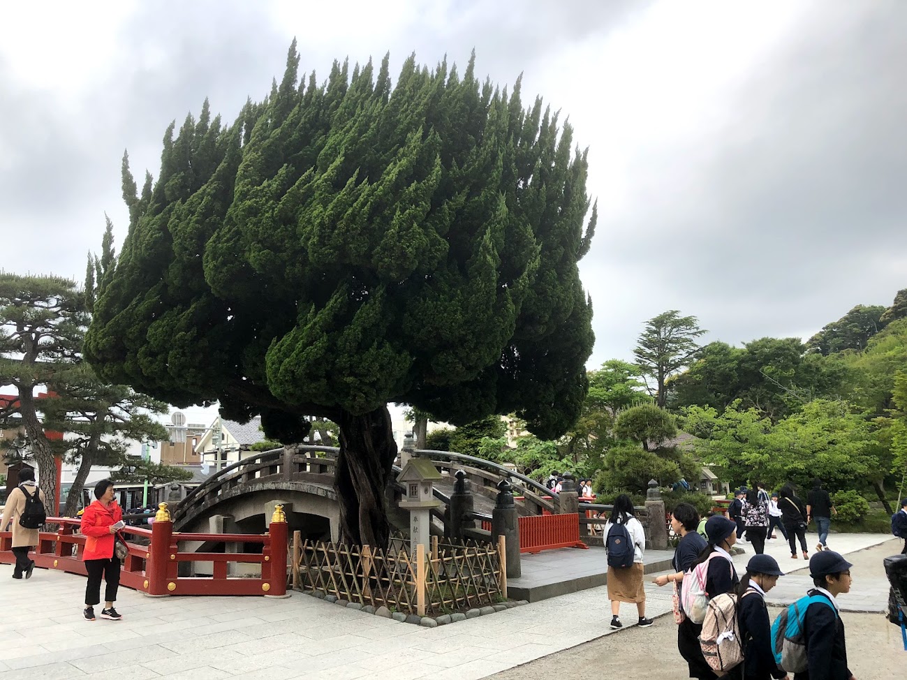
Before Kitami Kamakura Station, it is a famous scenic temple”Enkakuji Temple”.
Kenzoji Temple
In addition, although it is natural, since the Ten-en course passes through the precincts of Kenchoji temple, an admission fee is required. (Pay 300 yen)
When going to the direction length of Kencho-ji and passing too far, it becomes small diameter. It is a Hanzoubou road leading from here to Hanzoubou.
They are Hanzoubou Tengu! The Hanzoubou shrine is coming soon.
Hanzoubou located at the far end of Kenchou temple, where the whole valley is in the precincts. When you climb up the curved stone steps, the statues of the Tengu line up, creating an atmosphere different from the Zen temple like the Kenchou Temple at the foot.
Well, once you pass through the Hanzoubou, you enter the real mountain road. It is about 5 minutes from here to the winning dedicated observation deck. And about 2 hours to Zuisen temple.
Let’s follow the signs of Tenen-Hiking course.
I will advance the violent path of up / down.
My mood is Indy Jones!
The destination zuisen temple is 3.2km away.
There are narrowing, undulations.
Let’s enjoy a trail like a sense of athletics!
Finally arrived. Go through the mountain road that continued from Hanzoubou to the top of Mt. Oohira! Ten-En is a sighty square.
You can purchase beer, soft drinks and snacks at the Ten-En resting place, if it openned.
After running for about an hour the mountain path will end.
It is Zuisenji temple right after exiting the road from the mountain road.an admission fee is required. (Pay 200 yen)
It is almost like a Japanese garden on the moon of Zuisenji Tenple.
It is Kamakuraguu as he goes down the road for a while from Zuisen temple.
Apart from Kamakuraguu, there are many temples around here.
After running for a while, the most famous Tutuokahachimanguu in Kamakura appears.
There are many restaurants and souvenir shops around Tutuokahachimanguu.
We toast with German beer and sausage shop “Chouzume Ya”.
The road that leads from Tutuokahachimanguu to Kamakura station is called “Komachi Street”, and many shops and shops line up.It is a popular Matcha ice cream shop “Kamakura Chacha”.
You can choose the concentration of Matcha in your choice.
Eating out to Kamakura station is fun!
I arrived at Kamakura Station. Congratulations!
Do you need a guide for this hiking course?
If you are looking for guide of this hiking course, please refer to the following.
It is expensive to buy, but you can easily cook at your home.
Ingredients
Glutinous Rice (Mochi-gome, もち米) 3 cups
Water About 80% against Glutinous Rice
Rice Flour (Kome-ko, 米粉)
Recipe
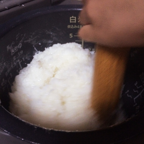
Wash the rice、and drain the one using a strainer.
Add the rice and weighed water to the rice cooker and cook as usual.
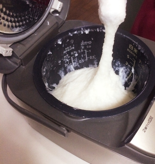
While rice is cooking, spread rice flour on cutting board. When rice is cooked, stir rice in rice cooker using a rolling pin.
When the grains of rice gathers to some extent, you will pound the rice next.
As you can see below, you have to try hard to pound until the rice become sticky.
Put rice cake on a cutting board.
Roll up rice cake to the size of your choice, and cook for a sticky rice cake (kinako-mochi, きな粉餅) and a rice cake with nori seaweed (isobe-yaki, 磯辺焼き).
Difficulty: ★ ☆ ☆ ☆ ☆
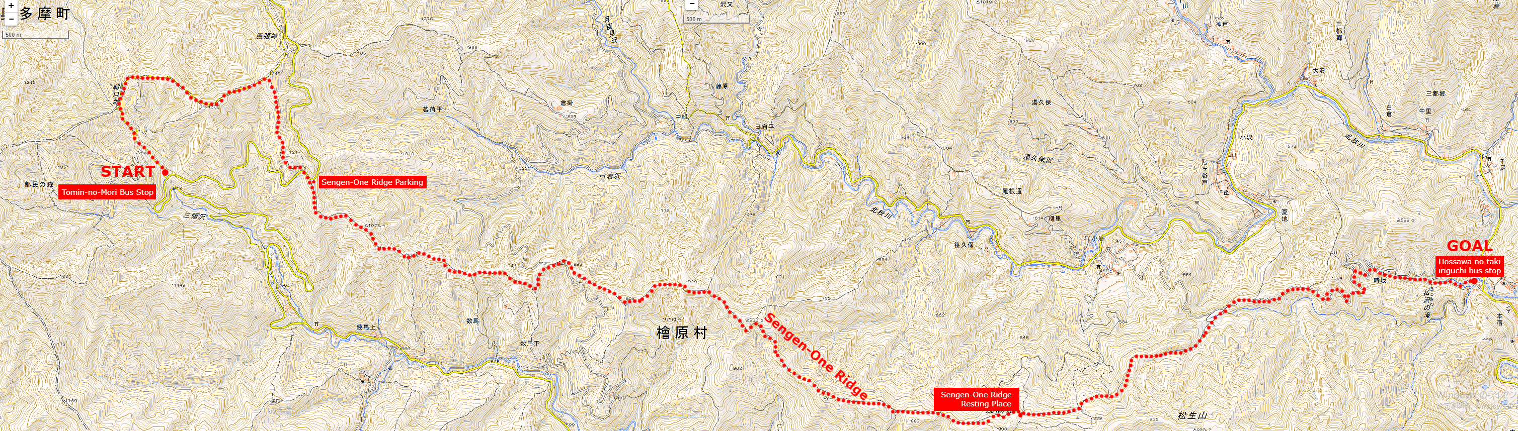
Start spot: Tomin-no-Mori Bus Stop 都民の森
Goul spot: Hossawa no taki iriguchi bus stop 払沢の滝入り口バス停
Total distance: 15.7 km
Total difference in elevation: 963 m
Hiking Course overview
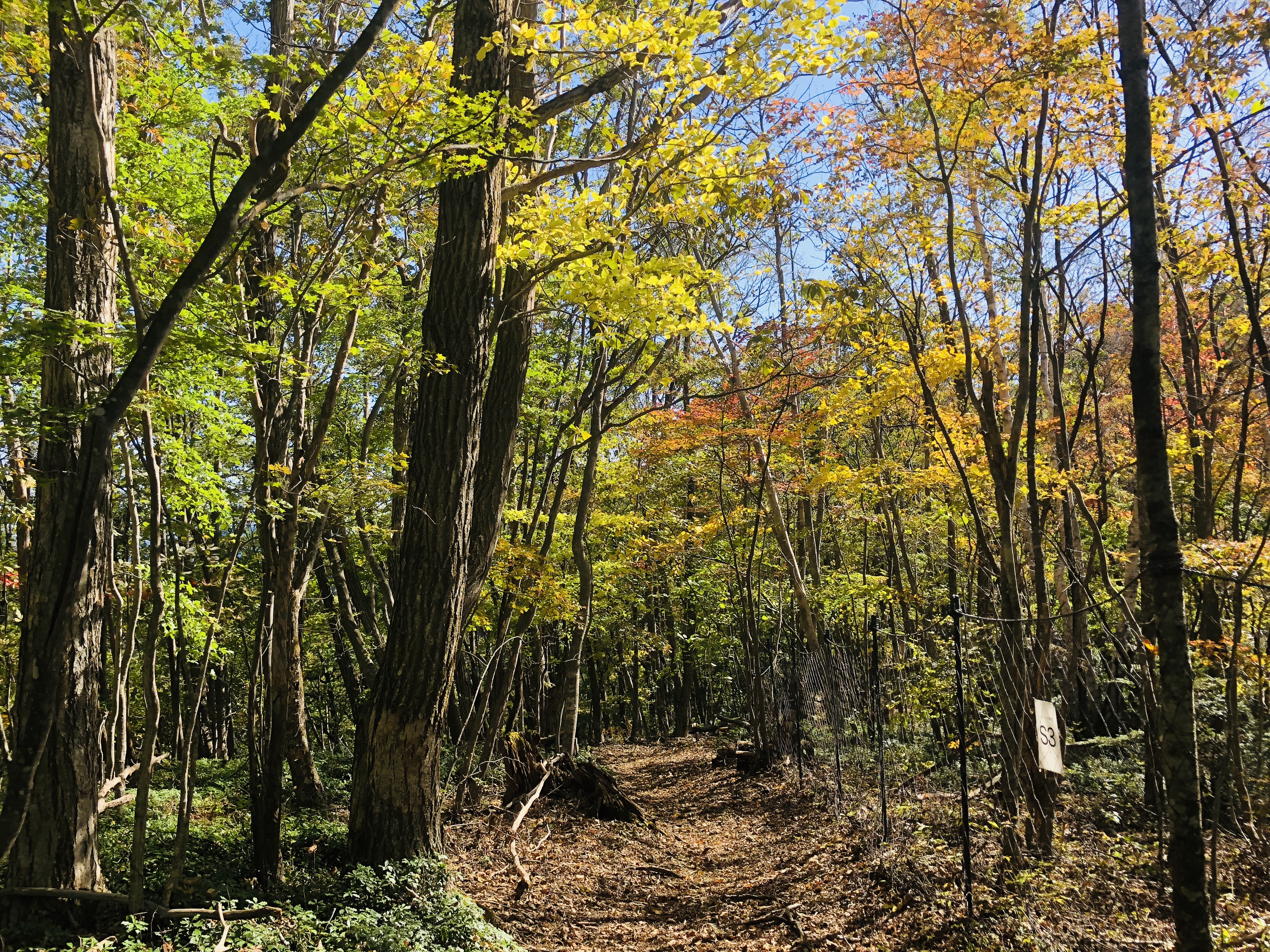
Go through the pleasant forest of a single track with few ups and downs.
1). Hinohara-Tomin-no-Mori Bus Stop 檜原 都民の森
2). Sengen-One Ridge Parking 浅間尾根駐車場
3). Sengen-One Ridge 浅間尾根
4). Sengen-One Ridge Resting Place 浅間尾根休憩場
5). Hossawa no taki iriguchi bus stop 払沢の滝入り口バス停
Map of “Sengen-One” Hiking Course
Clicking the image will display the enlarged size with a new tab.
Access
“Tomin-no-mori” is the trailhead of Mt. Mitou popular with hikers. Hiking routes are stretched all around in this area, but let’s proceed to “Kaze-hari-touge 風張峠” in this area.
JR Musashi-Itsukaichi Line End · From Musashi-Itsukaichi Station, take the West Tokyo bus to “Tomin-no-Mori Bus Stop 都民の森 バス停” for about 1 hour and 10 minutes.
On the way back, “the Hossawa no taki iriguchi bus stop払沢の滝入口 バス停” is used.
Or if you move to “Moto-shuku-yakubamae bus stop 本宿役場前 バス停”, the number of buses is large.
There is a free parking lot in “the Hossawa no taki iriguchi 払沢の滝入口”.
ADVICE
There is no public drinking fountain to the end of the course.
However, since there is a shop, vending machine, and toilet in the starting point “Tomin – no – Mori”, you can prepare here for running.
There is a lot of escape route to paved road called Hinohara – Kaidou in the way of Sengen – One, so beginners are safe course.
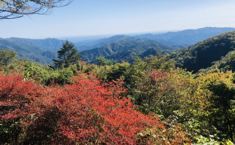
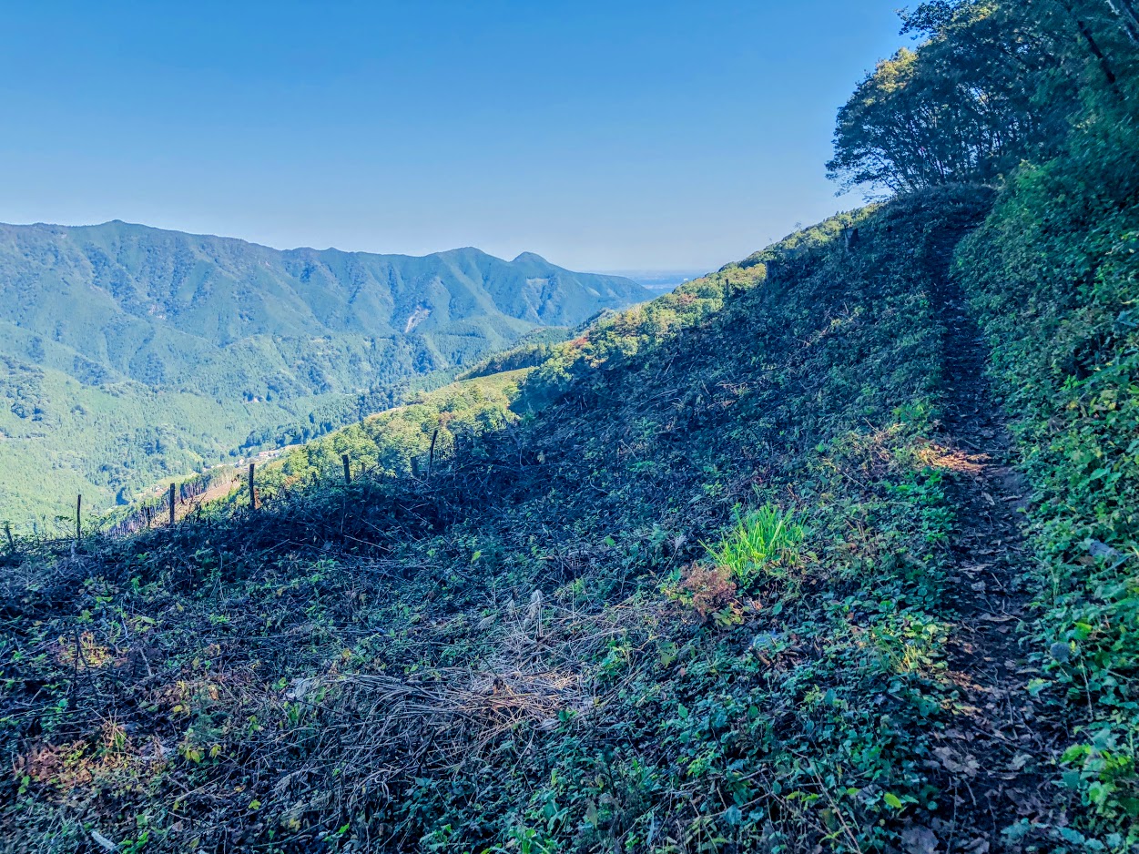
Features of “Sengen-One” course
The origin of the name of the ridge, “Sengen-One Ridge” is the highlight of the course.
This course is known to special people, you can down hill like crazy.
If you are thinking that “climing is the best part of hiking”, “You have ups and downs in life”, for such a hikers, this course can not be recommended. (I’m sorry)
Because the bus carries you to a high place, the course is generally in descending and on the way it is a runable trail with a flat part of about 5 km.
Therefore this course will be the best course for your hiking debut in Tokyo.
First of all,
Depending on the signpost in “Tomin-no-mori” you will go to “Saiguchi-Touge 鞘口峠”
It’s just a fine climb up to your warm-up.
Let’s proceed from “Saiguchi-Touge 鞘口峠” to “Kaze-hari-Touge 風張峠”.
As you go about 1.5 km, if the signpost of “Sengen-One 浅間尾根” appears, proceed to “Sengen-One 浅間尾根” direction.
Let’s move carefully since there are parts where the trail around here is collapsing.
Once you leave the paved road and enter the dart road again, the downhill of “Sengen-One Asama Ridge” will begin.
Because this course is easy to walk anyway, it is a satisfying course for those who want to run alone, those who want to enjoy at their own pace, both types of people.
Furthermore, since there are many escape routes and signs are substantial, I really recommend it for debuting hiking in Tokyo.
It is certainly inconvenient that the bus is indispensable to the starting point of the hiking course, but thanks to that, the course has few people crowded.
Moreover, it is mostly gentle downhill, mostly single track, you can monopolize luxurious course.
Perhaps you will face your face with your colleagues and say “Feel so good!”
After hiking…
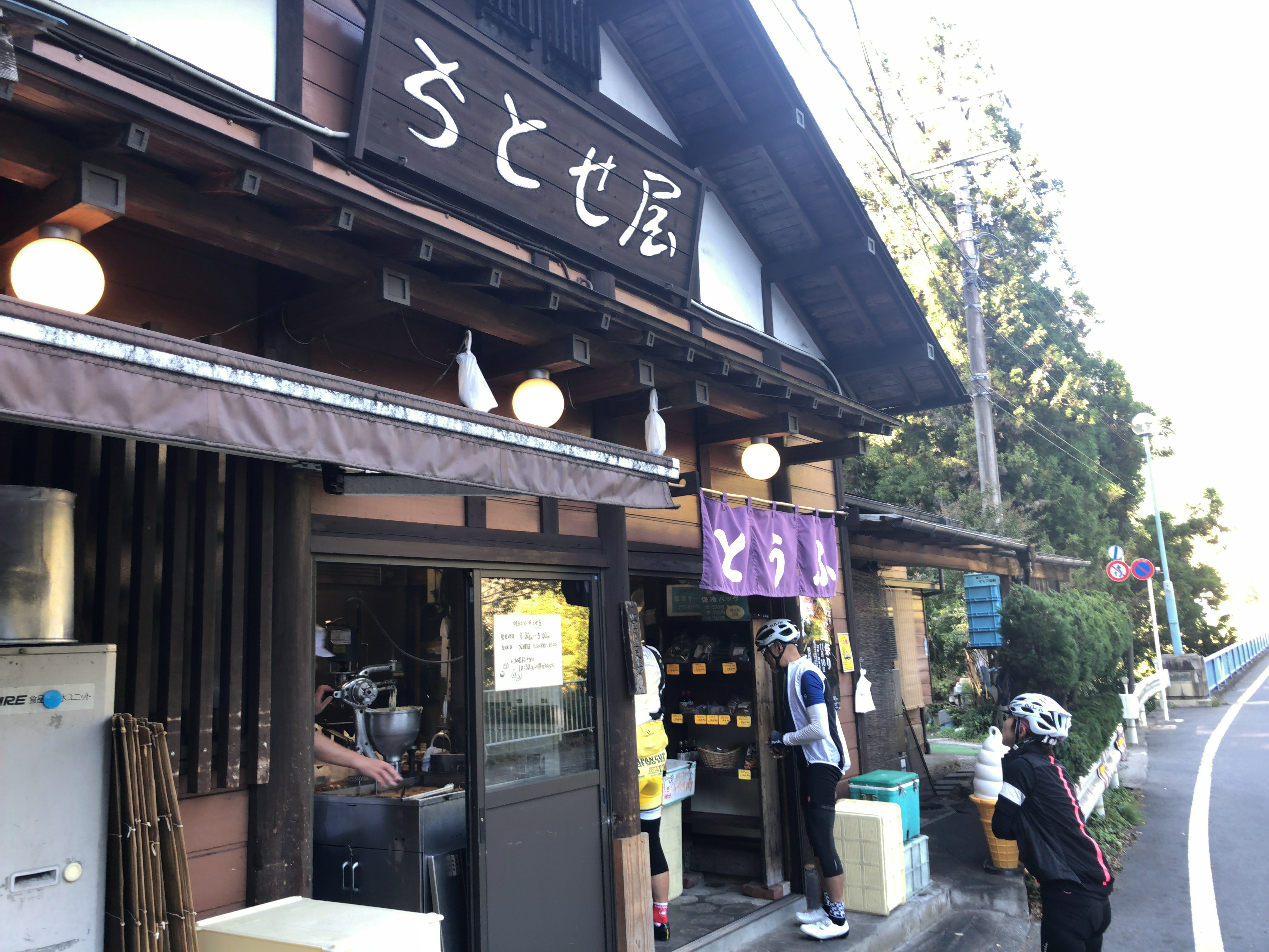
Hinohara-Tofu Chitose-ya
Tofu store in front of “Hossawa no taki iriguchi bus stop”.
Tofu using Hinohara’s source water and Hokkaido soybean is a rich flavor.
We also recommend popular menu fried donuts and soy milk, both of which are 100 yen.
Do you need a guide for this hiking course?
If you are looking for guide of this hiking course, please refer to the following.
This hiking course is a secret long trail that you can experience a moderate downhill that continues in Tokyo in Japan.
The hiking Course in the west mountain area of Tokyo is named “Sengen-ridge”, you can arrive by train and bus in about two hours.
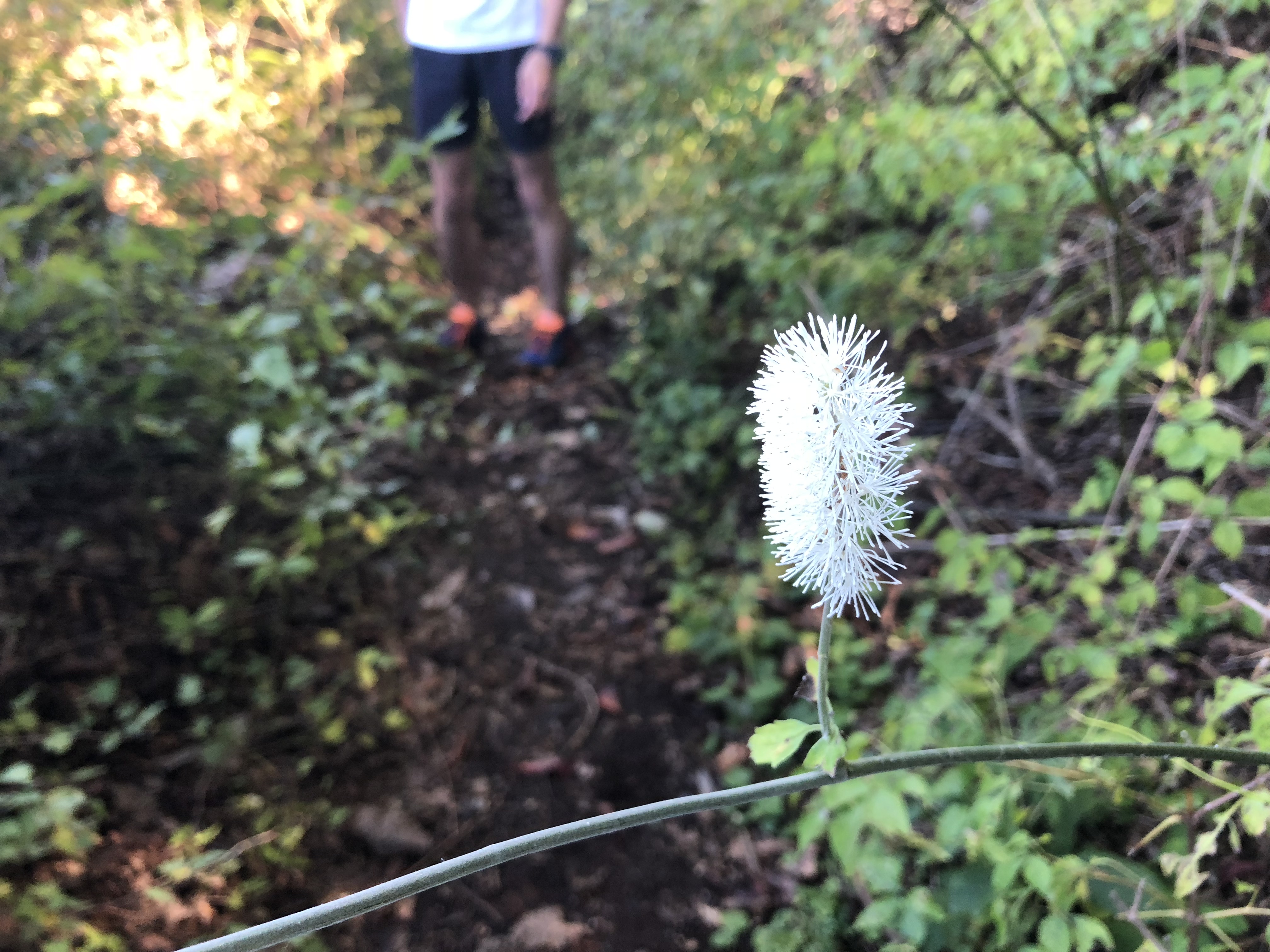
You may feel a little far, but as you get off the bus it is a world of altitude 1000 meters. Then only you can down hill like crazy with enjoying beautiful nature and lovely flowers and magnificent mountains.
If you are a hiker, and if you plan to come to Tokyo, I’d definitely want to introduce you to the course.
Tour details
Price : 3500 yen per person
Distance : 15.7 km
Private Tour (Your family and friends are OK.)
Difficulty : ★☆☆☆☆
Language : English, Japanese
Meeting point : Shinjuku Station or Musashi-itsukaichi station (武蔵五日市駅) on the JR Itsukaichi Line.
The exact meeting point will be set by your guide after booking confirmation, but I respond flexibly according to your area of accommodation. Transportation to the start point is not included in the tour price.
Meeting time : It is necessary to arrive at Musashi-itsukaichi station at least at 8:45 am because of the departure time of the bus.
What you can experience at this Course :
・Hosawa Waterfall
・Wildflowers (spring to autumn)
・Mountain Views
・Soba Restaurant in Mountain village (spring to autumn)
・Tofu Donuts Shop
・Hot Spring (optional)
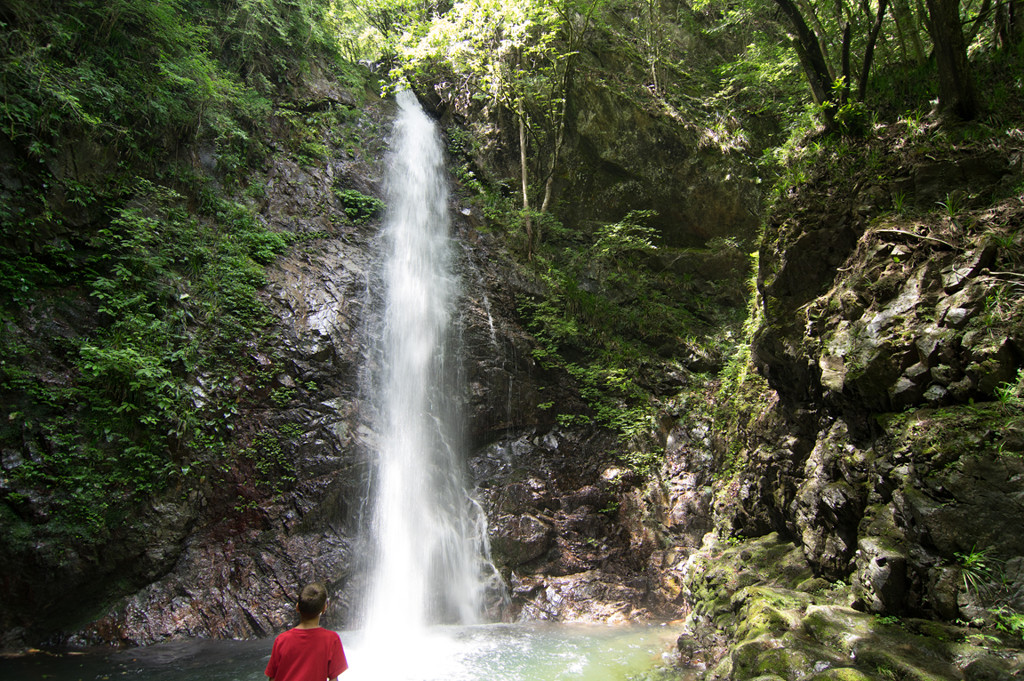
There is a soba restaurant in this course and you can enjoy local food in traditional Japanese traditional houses. The final destination, Hosawa Waterfall, is a beautiful waterfall with a height of 62 meters, and it is the only one in Tokyo that has been chosen as “100 Japanese Waterfalls.”
There is a popular donut shop in front of the bus stop on the way back, and Tofu Donuts using soy pulp as a material is delicious.
For more information on this hiking course, click here.
Disclaimer
Please read and give me consent before booking for this tour.
Hiking is an inherently dangerous activity that can lead to serious injuries including but not limited to slip and fall injuries, fractures, snake bite, heat exhaustion, poison oak, ticks and frostbite. By participation in this event you agree to not hold these organizers liable for any harm that may come to you, your guests, or your property. Always remember to let the event organizer know if you are leaving the group. Stay on the trail, never walk alone and use your own common sense.
Booking Now
[contact-form-7 id=”4392″ title=”Private Hiking Guide to Sengen Ridge | Beautiful Long Down Hill in Okutama”]
This trail is a secret long trail that you can experience a moderate downhill that continues in Tokyo in Japan.
The trail in the west mountain area of Tokyo is named “Sengen-one-ridge”, you can arrive by train and bus in about two hours.
You may feel a little far, but as you get off the bus it is a world of altitude 1000 meters. Then only you can down hill like crazy with enjoying beautiful nature and lovely flowers and magnificent mountains.
If you are a trail runner, and if you plan to come to Tokyo, I’d definitely want to introduce you to the trail.
Tour details
Price : 3500 yen per person
Distance : 15.7 km
Private Tour (Your family and friends are OK.)
Difficulty : ★☆☆☆☆
Language : English, Japanese
Meeting point : Shinjuku Station or Musashi-itsukaichi station (武蔵五日市駅) on the JR Itsukaichi Line.
The exact meeting point will be set by your guide after booking confirmation, but I respond flexibly according to your area of accommodation. Transportation to the start point is not included in the tour price.
Meeting time : It is necessary to arrive at Musashi-itsukaichi station at least at 8:45 am because of the departure time of the bus.
What you can experience at this Course :
・Hosawa Waterfall
・Wildflowers (spring to autumn)
・Mountain Views
・Soba Restaurant in Mountain village (spring to autumn)
・Tofu Donuts Shop
・Hot Spring (optional)
There is a soba restaurant in this course and you can enjoy local food in traditional Japanese traditional houses. The final destination, Hosawa Waterfall, is a beautiful waterfall with a height of 62 meters, and it is the only one in Tokyo that has been chosen as “100 Japanese Waterfalls.”
There is a popular donut shop in front of the bus stop on the way back, and Tofu Donuts using soy pulp as a material is delicious.
Please read and give me consent before booking for this tour.
Trail running is an inherently dangerous activity that can lead to serious injuries including but not limited to slip and fall injuries, fractures, snake bite, heat exhaustion, poison oak, ticks and frostbite. By participation in this event you agree to not hold these organizers liable for any harm that may come to you, your guests, or your property. Always remember to let the event organizer know if you are leaving the group. Stay on the trail, never run alone and use your own common sense.
Booking Now
[contact-form-7 id=”4387″ title=”Private Trail Running Guide to Sengen Ridge | Beautiful Long Down Hill in Okutama”]
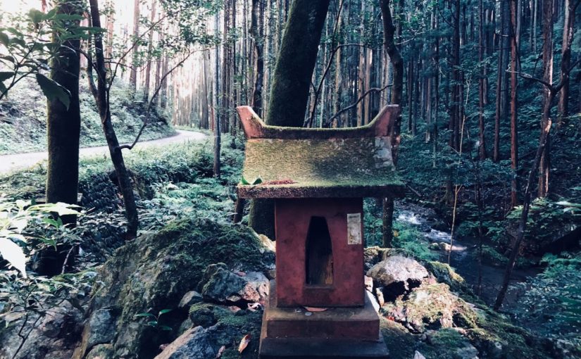
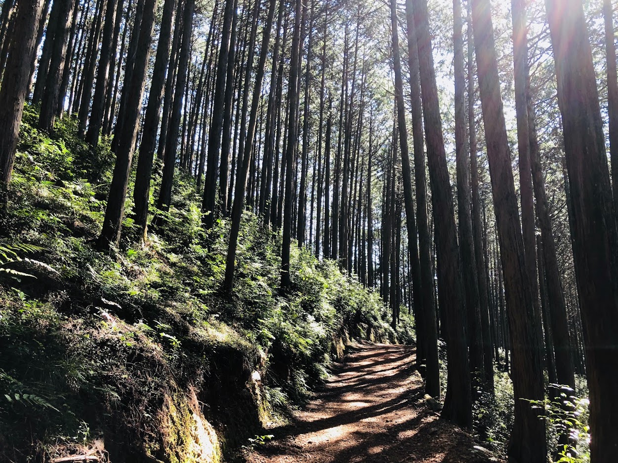
One of the most mysterious and attractive hiking courses in Japan is Aokigahara’s hiking course.
The forest called the sea of trees (Jukai, 樹海) is a place full of natural, powerful life.
There is an unspoilt primeval forest, there is magnificent Mt.Fuji in front of you, there is a caves. It is a hiking course with plenty of adventure elements.
Tour details
Price : 4500 yen per person
Distance : 11 km
Private Tour (Your family and friends are OK.)
Difficulty : ★☆☆☆☆
Language : English, Japanese
Meeting point : Shinjuku Station or Mt. Fuji Station (Fujisan-eki, 富士山駅) on the Fujikyuko Line.
The exact meeting point will be set by your guide after booking confirmation but will be in the area of either Mt.Fuji Station, or Shinjuku Station in Tokyo. Transportation to the start point is not included in the tour price.
Meeting time : It is necessary to arrive at Fuji Station by 9:30 am.
What you can experience at this Course :
・Mt. Fuji magnificent view from Kōyō-daix (Koyadai, 紅葉台)
・Ice holes created about 1,000 years ago
・Mysterious and beautiful Aokigahara Jukai
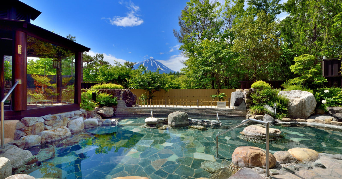
・Hot spring while watching Mt. Fuji (optional)
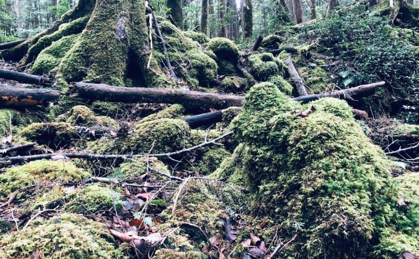
The land of Aokigahara is almost covered with beautiful green moss.
Hike to Aokigahara is a very exciting and relaxing experience.
The hiking course is primarily flat because of the vast land and not mountains.
Of course, because it is a natural road, there are some irregularities, but basically you will be able to enjoy safe and comfortable hiking.
If weather is good from Kōyōdai (Koyodai, Kodai-dai) you can see magnificent Mt. Fuji. Unfortunately this day it was cloudy day.
There are two large caves on these courses, which are called Togaku Wind Cave(Togaku-fūketsu, 富岳風穴) and Narusawa Ice Hole(Narusawa-hyō-ketsu, 鳴沢氷穴), both of which are natural caves made more than 1000 years ago, you can experience the exploration of the underground world .
And Kōyōdai(Koyodai, 紅葉台), the last destination of this course, will offer you the best view of Mt. Fuji if it is sunny.
If you want it you can relax and return home completely with natural hot springs.
Please read and give me consent before booking for this tour.
Hiking is an inherently dangerous activity that can lead to serious injuries including but not limited to slip and fall injuries, fractures, snake bite, heat exhaustion, poison oak, ticks and frostbite. By participation in this event you agree to not hold these organizers liable for any harm that may come to you, your guests, or your property. Always remember to let the event organizer know if you are leaving the group. Stay on the trail, never run alone and use your own common sense.
Booking Now
[contact-form-7 id=”4378″ title=”Private Hiking Guide to Aokigahara | Explore the Sea of Trees!”]
・Mt. Fuji magnificent view
・Ice hole created about 1,000 years ago
・Mysterious and beautiful Aokigahara Jukai
・Hot spring while watching Mt. Fuji
Jukai’s running course :
jukai
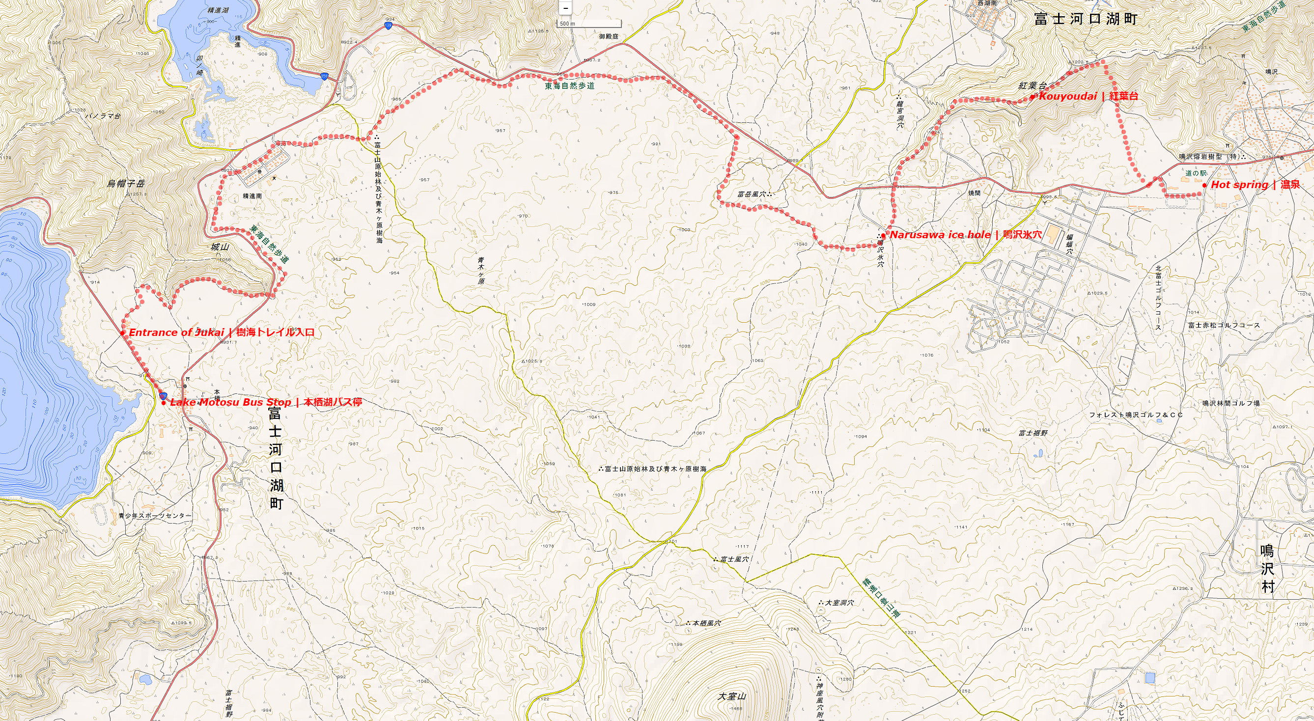
The Aokigahara Jukai is a vast primitive forest spreading over Lake Motosu, Lake Saiko, Lake Shoujin, which is the foot of Mount Fuji.
On this day I started from the side of Lake Motosu, passed by Lake Shoujin, stopped by ice hole and the highlight looked at Lake Saiko from Kouyoudai.
I could completely relax at the goal’s hot spring, because in this hot spring I can soaking in a natural hot water while looking at the magnificent view of Mt.Fuji.
A landscape with 300 years old trees such as fir and beech growing on the lava flows is beautiful and you can enjoy a mysterious sight as if you landed on another planet that is not the earth.
If you believe that you get lost if you go to Jukai it is a mistake.
The hiking road is well maintained and easy to understand and it is not easy to get lost as it is installed along the national highway.
People who are likely to get lost are people who ignore hiking roads for the purpose of collecting mushrooms and wild plants.
There are some ancient ice holes in jukai.
The Narusawa ice hole which I visited that day is a natural cave that was created about 1,000 years ago and you can experience the world of ice with an average annual temperature of 3 degrees.
If you will visit at Jukai for hiking, you can cool down your body that burned for the running at this ice hole.
Also,
On Kouyoudai, you may be able to see the magnificent view of Mt.Fuji that is colored with autumn leaves. (If you visit in early November. )
Since the goal is a hot spring, you can take a return trip after healing the tired body slowly.
Difficulty of this course :
It is Beginners Level.
Although there are some ups and downs, it is a relatively flat road of about 15 km.
This course is also recommended for hiking beginners.
Belongings :
· Shoes for hiking
It is okay if you do not have shoes for hiking.
However, please be aware that there are some uneven parts.
· Backpack for hiking
It is okay if you do not have a backpack for hiking.
However, a backpack that is easy for you to run is good.
Mt. Fuji station (9:30) → departure from the bus (9: 50) → Lake Motosu (10:50) → trailhead (11:10) → snack break (13: 00) → Narusawa ice hole (14: 00) → Kouyoudai (15: 00) → hot spring (15: 30)
Jukai Hiking Course Map :
Jukai Hiking Map | Click on the image above and you can see the enlarged version.
Recommended after running :
Fuji viewing hot spring Yurari | 富士眺望の湯 ゆらり
Address :
8532-5 Narusawa village South Tsuru County, Yamanashi Prefecture Tel: 0555-85-3126 website: https://www.fuji-yurari.jp/ Map:
Closed: open 365 days per year Business hours: 10: 00 ~ 22: 00 Reception is until 21:00 Usage fee: (Rental bath towel with face towel)
■ 10: 00-19: 00
Weekday 1,300 yen Saturday, Sunday and public holidays 1,500 yen
■ 19: 00-22: 00
Weekday 1,100 yen Saturday, Sunday and public holidays 1,300 yen
Do you need a guide for this hiking course?
If you are looking for guide of this hiking course, please refer to the following.
One of the most mysterious and attractive hiking trails in Japan is Aokigahara’s trail.
The forest called the sea of trees (Jukai, 樹海) is a place full of natural, powerful life.
There is an unspoilt primeval forest, there is magnificent Mt.Fuji in front of you, there is a caves. It is a hiking course with plenty of adventure elements.
Tour details
Price : 3000 yen per person
Distance : 11 km
Private Tour (Your family and friends are OK.)
Difficulty : ★☆☆☆☆
Language : English, Japanese
Meeting point : Shinjuku Station or Mt. Fuji Station (Fujisan-eki, 富士山駅) on the Fujikyuko Line.
The exact meeting point will be set by your guide after booking confirmation but will be in the area of either Mt.Fuji Station, or Shinjuku Station in Tokyo. Transportation to the start point is not included in the tour price.
Meeting time : It is necessary to arrive at Fuji Station by 9:30 am.
What you can experience at this Course :
・Mt. Fuji magnificent view from Kōyō-daix (Koyadai, 紅葉台)
・Ice holes created about 1,000 years ago
・Mysterious and beautiful Aokigahara Jukai
・Hot spring while watching Mt. Fuji (optional)
The land of Aokigahara is almost covered with beautiful green moss.
Aokigahara trail running is a very exciting and relaxing experience.
The running course is primarily flat because of the vast land and not mountains.
Of course, because it is a natural road, there are some irregularities, but basically you will be able to enjoy safe and comfortable trail running.
If weather is good from Kōyōdai (Koyodai, Kodai-dai) you can see magnificent Mt. Fuji. Unfortunately this day it was cloudy day.
There are two large caves on these courses, which are called Togaku Wind Cave(Togaku-fūketsu, 富岳風穴) and Narusawa Ice Hole(Narusawa-hyō-ketsu, 鳴沢氷穴), both of which are natural caves made more than 1000 years ago, you can experience the exploration of the underground world .
And Kōyōdai(Koyodai, 紅葉台), the last destination of this course, will offer you the best view of Mt. Fuji if it is sunny.
If you want it you can relax and return home completely with natural hot springs.
Please read and give me consent before booking for this tour.
Trail running is an inherently dangerous activity that can lead to serious injuries including but not limited to slip and fall injuries, fractures, snake bite, heat exhaustion, poison oak, ticks and frostbite. By participation in this event you agree to not hold these organizers liable for any harm that may come to you, your guests, or your property. Always remember to let the event organizer know if you are leaving the group. Stay on the trail, never run alone and use your own common sense.
Booking Now
[contact-form-7 id=”4364″ title=”Private Trail Running Guide to Aokigahara”]
Oku Musashi nature sidewalk (Okumusashi shizen hodō, 奥武蔵自然歩道) is a natural sidewalk in Saitama Prefecture.
A trail with a total length of 11 kilometers can be enjoyed by several low mountains followed by lakes, seasonal plants and various animals.
The low mountains of about 300 m in altitude can be said to be a nature trail suitable for beginner trail runner.
Tour details
Price : 3000 yen per person
Distance : 11 km
Private Tour (Your family and friends are OK.)
Difficulty : ★☆☆☆☆
Language : English, Japanese
Meeting place : Ikebukuro Station
Meeting time : negotiable
Trail Running to Oku Musashi nature sidewalk
Trails are well maintained and there are few dangerous places.
Oku Musashi Nature Trail is a course generally departing from Hanno station, but I recommend a course from Musashiyokote Station.
Because there are few hikers in this trail, you can enjoy quiet and peaceful forests and flowers.
At the summit of Mt. Hiwada you can see a superb mountain view and a lovely shrine.
It is also possible to walk while watching various beautiful flowers depending on the season, and chose a hot spring for the goal.
Why not try escaping the bustle of Tokyo and heal your mind and body with simple trail running?
Please read and give me consent before booking for this tour.
Trail running is an inherently dangerous activity that can lead to serious injuries including but not limited to slip and fall injuries, fractures, snake bite, heat exhaustion, poison oak, ticks and frostbite. By participation in this event you agree to not hold these organizers liable for any harm that may come to you, your guests, or your property. Always remember to let the event organizer know if you are leaving the group. Stay on the trail, never run alone and use your own common sense.
Booking Now
[contact-form-7 id=”4332″ title=”Private Trail Running Guide to Oku-Musashi Nature”]
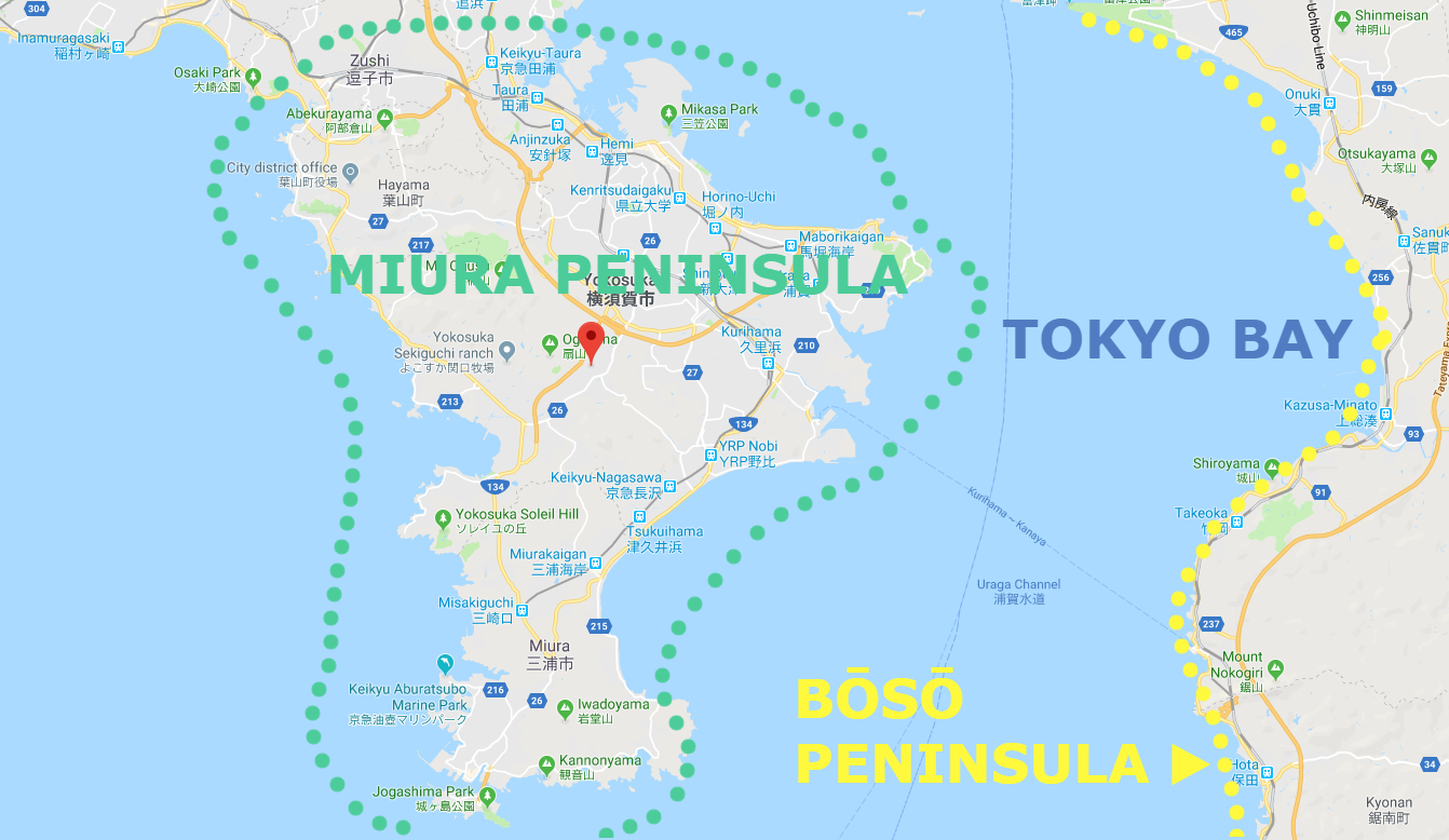
Miura Peninsula, the part of Kanagawa Prefecture to the south of Tokyo, just out into the Pacific Ocean and, together with the Bōsō Peninsula, forms Tokyo Bay.
Among them, Miura Reef Route, the last remnants of untouched coast provide probably the great walking course close to Tokyo, and are excellent for the less adventurous walker.
The Keihin Kyūkō Line (from Shinagawa) and its associated branches serve most areas, with JR Yokosuka Line an alternative in some cases.
Guide for hiking of Miura Reef Route
Area: Miura city, Kanagawa prefecture, Japan
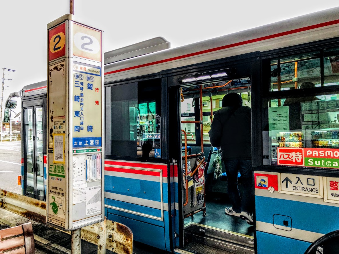
Access: From Keihin Kyūkō Miura Kaigan Station, board a Keihin Kyūkō Bus bound for Cape Tsurugi (Tsurugizaki, 劒崎) for 20 minutes, get off at Tsurugizaki
Start: Tsurugizaki Bus Stop 劒崎バス停
Goal: Miyakawa-cho Bus Stop 宮川町バス停
Difficulty of this trail: ★ ☆ ☆ ☆ ☆
Trail appearance rate: ★ ☆ ☆ ☆ ☆
Total distance: 10.3 km
Total difference in elevation: 40 m
Walking time: 3 hours
Point of interest: Rugged coastline and sea views, Cape Tsurugi Lighthouse, Caves, Dwellings of the Yayoi people, and Seaweed cultivation.
Note: At high tide, the route may be impassable, if not dangerous.
Approximate times of high and low tides can be found on website below. https://www.tidetime.org/asia/japan/miura.htm
Access to Miura Reef Route
From Shinagawa Station, take a Keihin Kyūkō Line (京浜急行線) limited express (tokkyū, 特急) or a slightly faster and more comfortable rapid limited express (Kaisoku tokkyū, 快速特急) bound for Misaki-guchi (三崎口). The last part of the journey actually runs along the Keihin Kurihama Line (京浜久里浜線), but no transfer is needed. Get off at Miura-kaigan (三浦海岸) Station, the second from last stop.
Rapid limited expresses take just over 1 hour to reach Miura kaigan; limited expresses take 1 hour and 14 minutes; and other, slower trains considerably longer. The fare in all cases is 740JPY.
Please check the latest timetable, because the timetable and fare are sometimes changed.
Timetable and Route Serch “HyperDia” http://www.hyperdia.com/sp/index.html.en
Leave the station by the only exit, walk slightly to the right to Bus Stand No. 2, and board a bus bound for Cape Tsurugi (Tsurugizaki, 劒崎). The Bus route runs along the shoreline, providing good views of this beach that is popular with windsurfers.
After about 20 minutes, get off at Cape Tsurugi (Tsurugizaki, 劒崎) which is the terminus of this line. The fare is 290JPY.
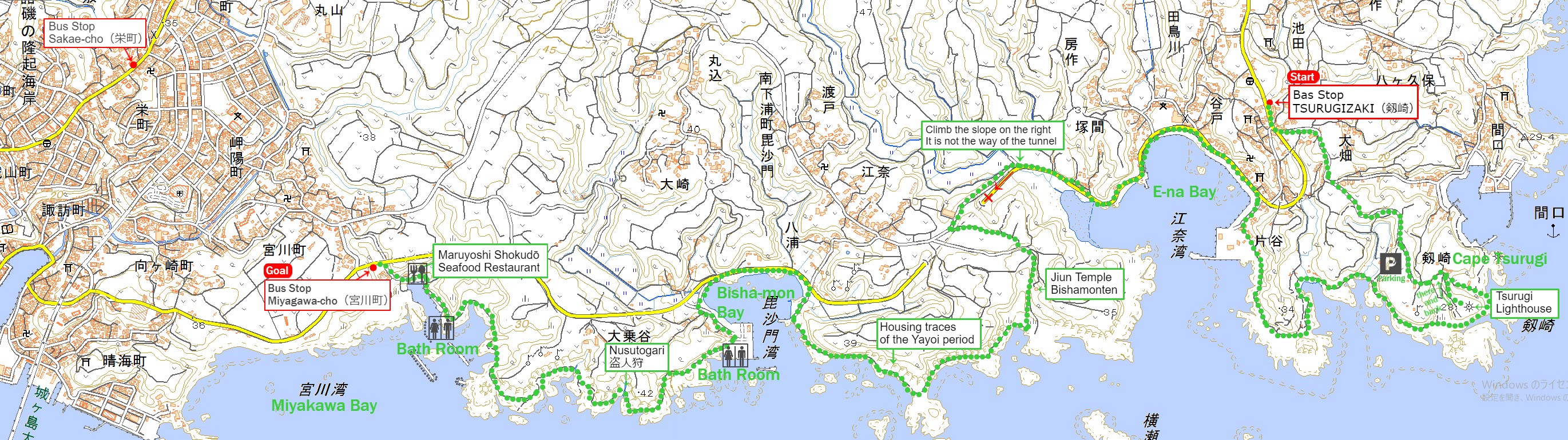
Maps of Miura Reef Route
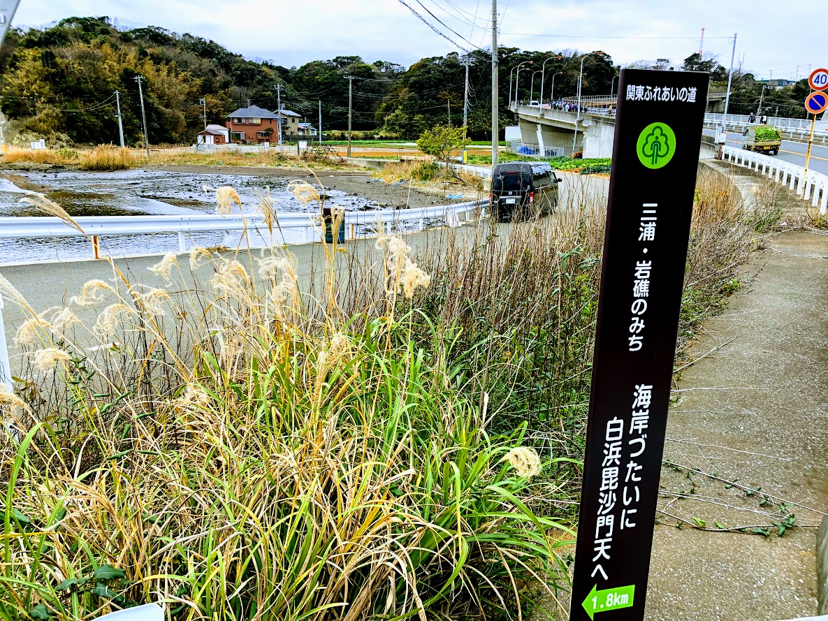
Miura Reef Route (the Miura Gansho no michi, 三浦 岩礁の道) is part of The Kantō Fureai Trail (Knatō Fureai no michi, 関東ふれあいの道) that the Japanese government’s Ministry of the Environment manages.
The whole map of Miura Reef Route (the Miura Gansho no Michi) | Clicking the image will display the enlarged size with a new tab.
The source of above the three maps are “Digital Japan Web System” of The Geospatial Information Authority of Japan. The maps were edited a author of this blog.
In Japanese: これらの3枚の地図は国土地理院の電子国土Webシステムから配信されたものをこのブログの著者が加工したものである。
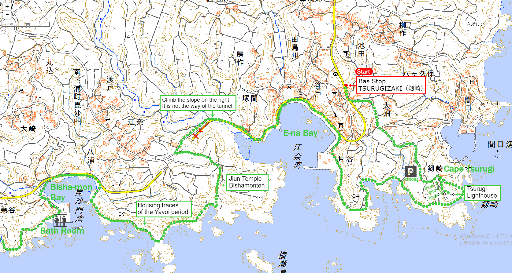
From Tsurugizaki Bus Stop (劒崎バス停) to Bisha-mon Bay (毘沙門湾)
The first half of Miura Reef Route(the Miura Gansho no Michi) | Clicking the image will display the enlarged size with a new tab.
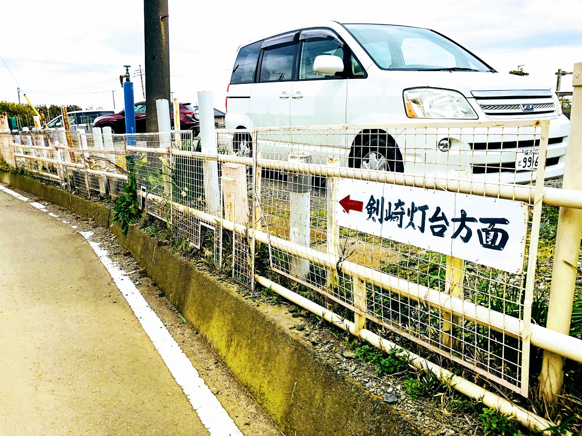
Walk along the road in the same derection as the bus wast traveling. You can find a small signboard with the direction of the Tsurugizaki lighthouse on the left side as you go about 50 meters.
A small signboard with the direction of the Tsurugizaki lighthouse (剣崎灯台方面).
After turning to the left according to the direction of signboard, the road of Daikon radish field continues. After a while you can see the lighthouse for the direction of travel, if the weather is good you can see Mt.Fuji when you look back on the road.
On this road, the track carrying Daikon radish is coming and going, the black kite is slowly flying in the sky. On the other side of the lighthouse is the sea, behind which there is the Bōsō peninsula. You will find the road to the Maguchi port on the left side, but ignore that road. When you walk toward the lighthouse, there is a parking lot on the right side, there is the bath room too.
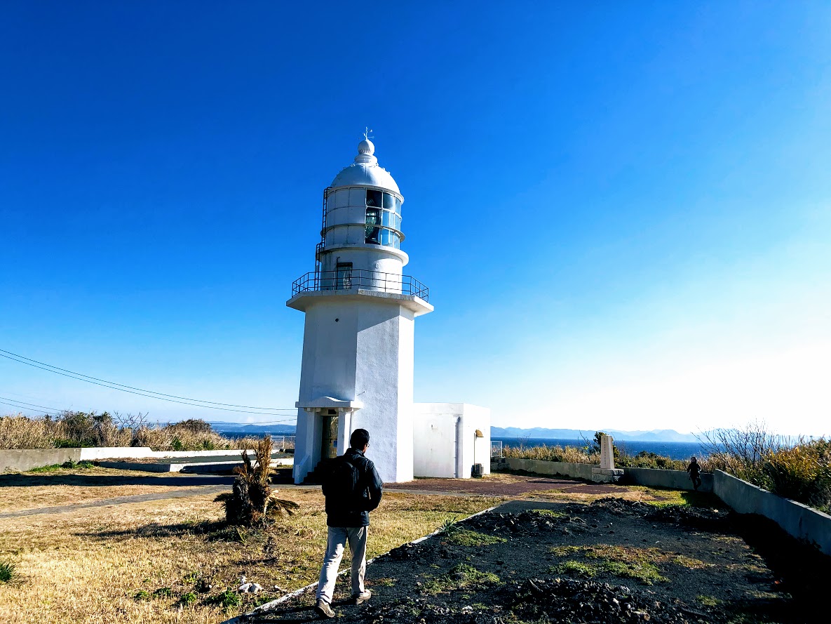
There is a branch to the lighthouse where you have gone a little from the parking lot. The path to the lighthouse is on the right side and the left is on the beach, the lighthouse will arrive in about 1 minute.
One of the eight lighthouses where the Edo Shogunate promised construction by the “Tax Treaty” tied with the four countries of the United States, the UK, France and the Netherlands in 1866. The designer was Richard Henry Brunton.
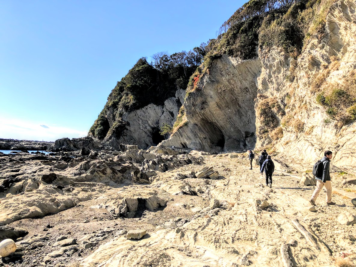
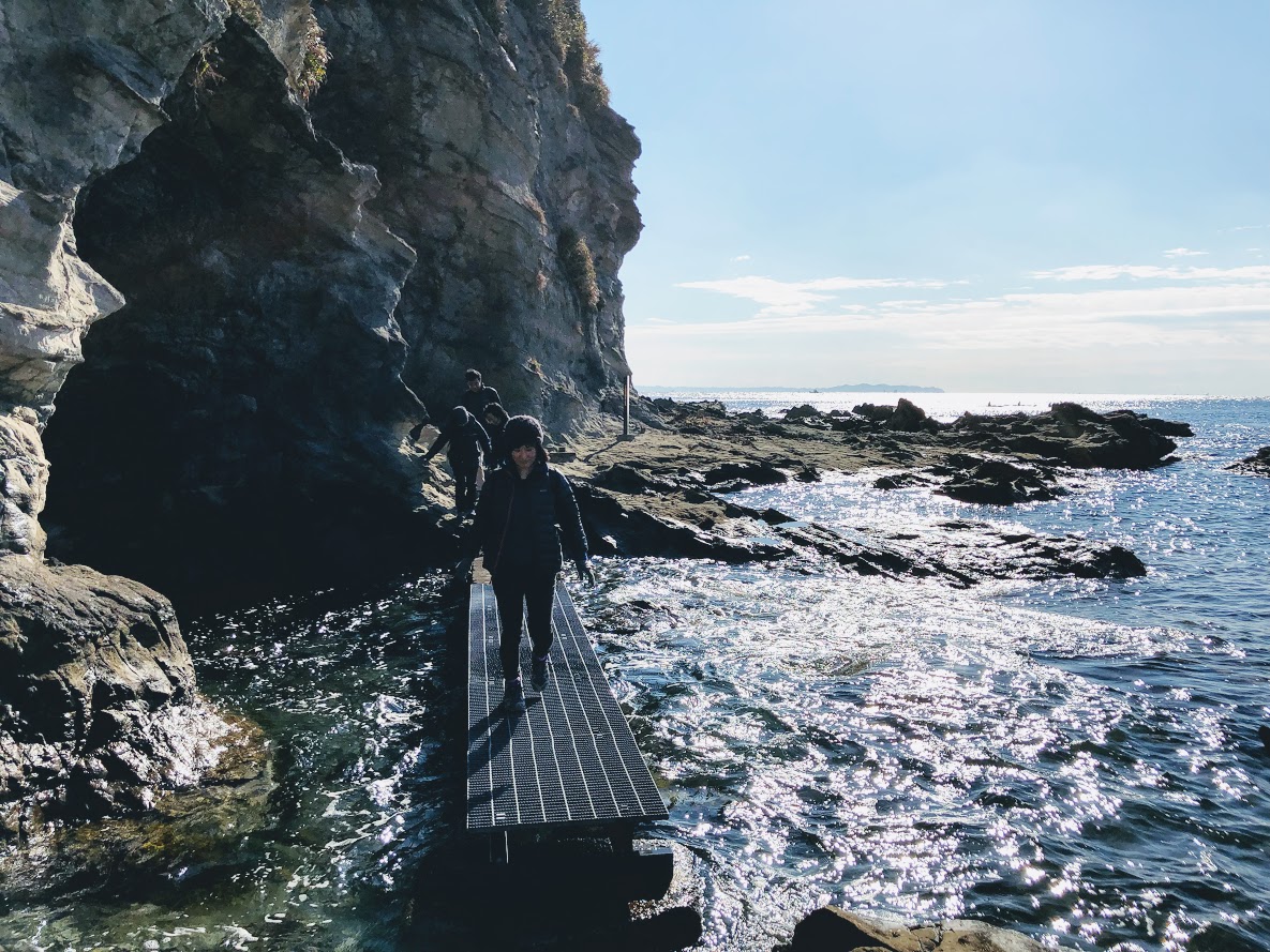
Go back to the lighthouse and go down the road on the left and you will come to a small beach. As you go to the right along the coast, rocky road will continue for a while. There are some dangerous places that will injure if you fall, choose a place that you can easily walk on and take care.
There are roads that submerge at high tide.
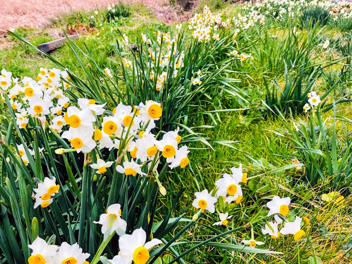
You advance along the rocky road along the coast until Ena Bay. Once from Ena Bay, go to the prefectural road and proceed a quiet fishing village. There is a convenience store on the way and you can buy snacks and drinks. Ena Bay is a small tidal flat and you can see various kinds of crab and shellfish in the summer. In winter you can see a white daffodil blooming on the shore.
daffodil (suisen, 水仙) Jaunuary, 2019
There is a branch on the slope along the paved road along Ena Bay.
Let’s go to the right slope, not the road of the left tunnel.
Let’s not miss a signbourd on the left side as you climb up the slope. Turn left at the sign and go straight to the old Jiun Temple. Once it passes through the temple, the reef route will start again.
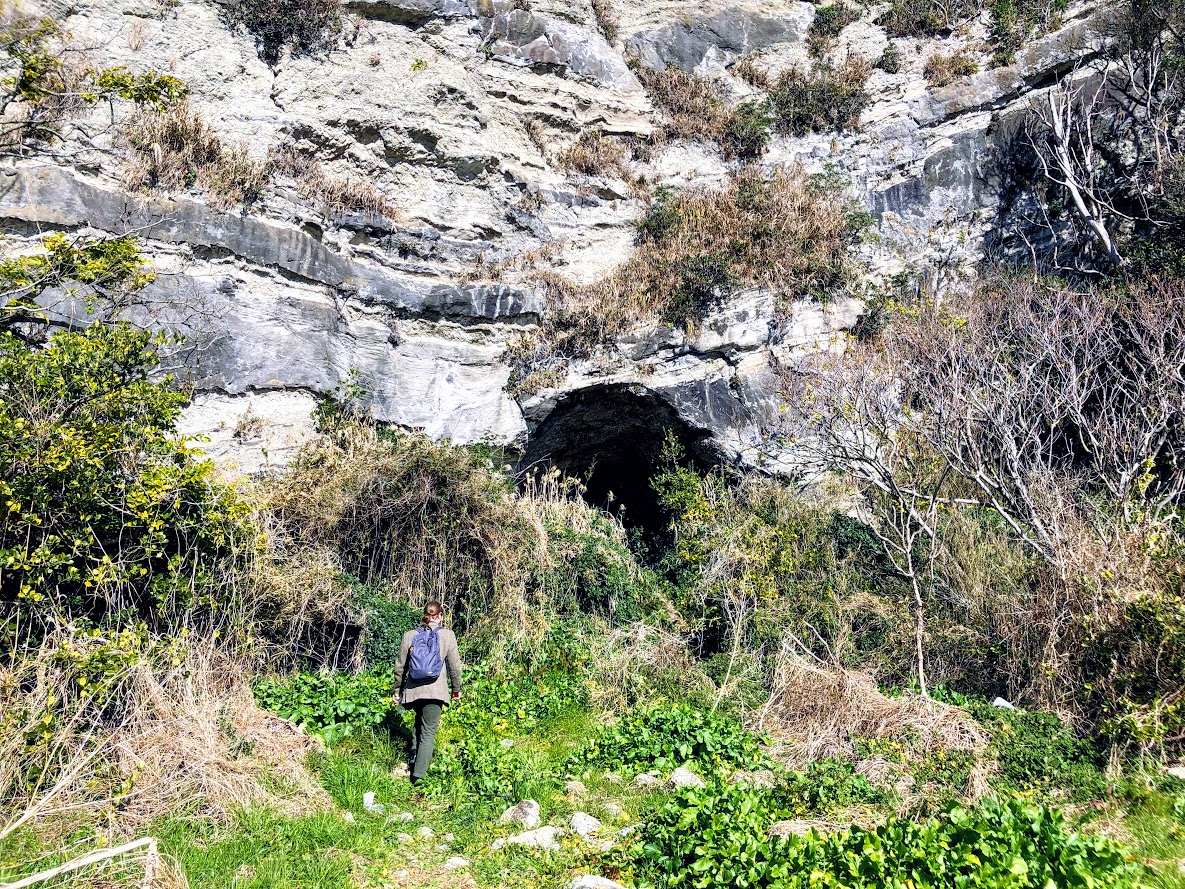
You will have a big cave as you go along the rocky road for a while.
This is the residence of the Yayoi era you can enter inside.
Dwellings of the Yayoi people (from the 10th century BC to the 3rd century AD)
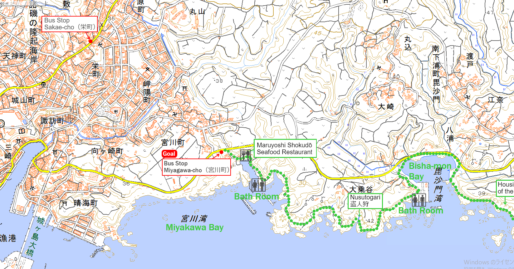
From Bisja-mon Bay (毘沙門湾) to Miyagawa-cho Bus Stop (宮川町バス停)
The latter half of Miura Reef Route (the Miura Gansho no Michi) | Clicking the image will display the enlarged size with a new tab.
When you arrive at Bisha-mon Bay you will walk the prefectural road again paved for a while. Let’s not miss the signbord of The Kantō Fureai Trail on the left side, find the signbord and follow the arrow and turn left.
the signbord of The Kantō Fureai Trail
Go through the small fishing port. There is a bath room although it is not very clean in the fishing port.
If you pass this a bath room, the reef route will start again.
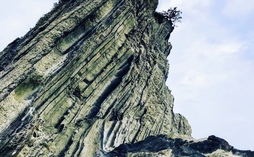
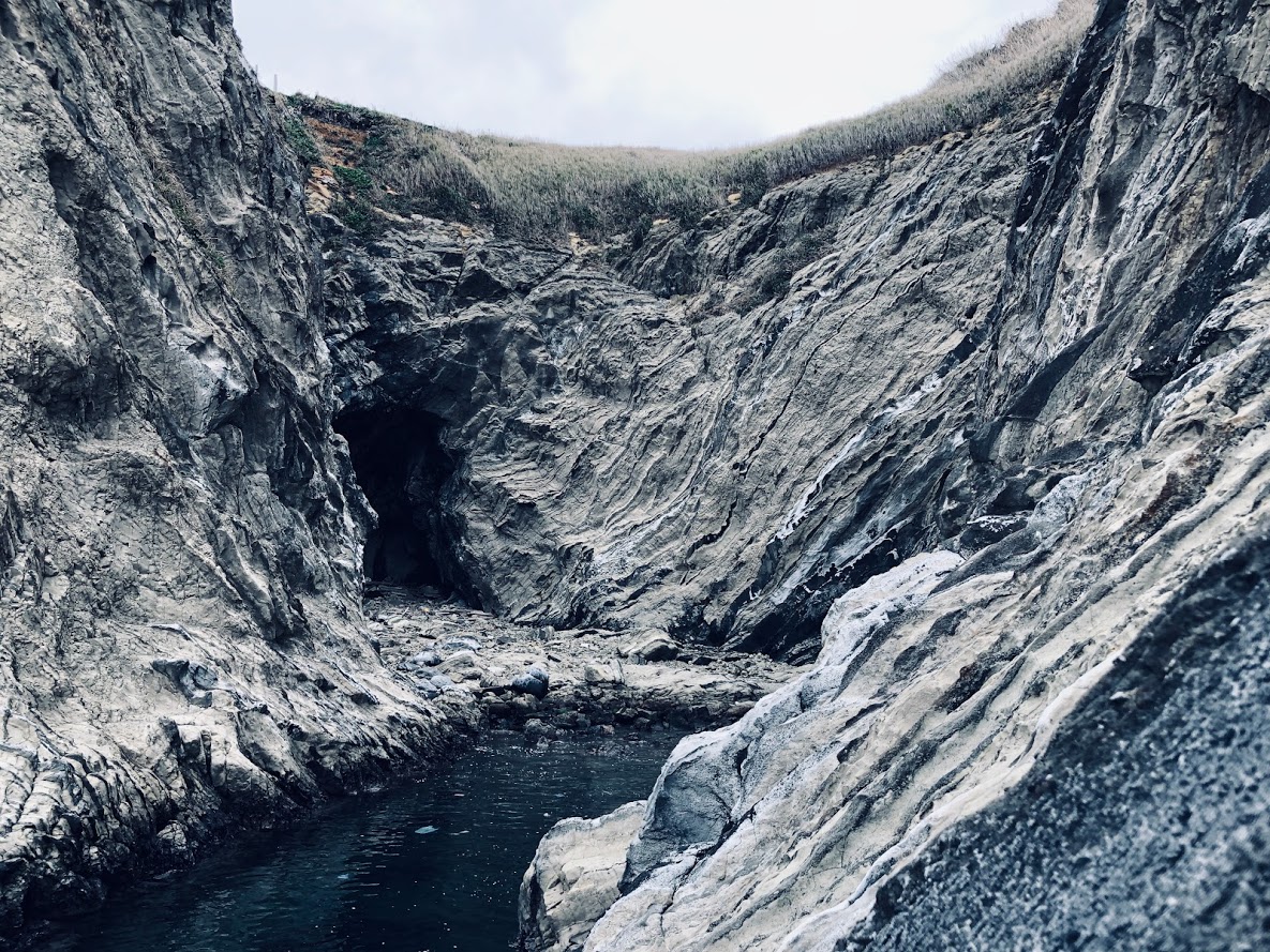
While enjoying the strange and beautiful rocks scattered by the wind and wave, You will arrive at a splendid cliff called Nusutogari.
Nusuto (盗人) means a thief in Japanese, gari (狩) means arresting.
It is said that a thief who fled to this cliff was unable to move due to fear on the cliff, and this name comes from that legend.
Nusutogari (盗人狩)
Pass through some big caves from Nusutogari and you will arrive at Miyagawa Bay, the end of the reef route. This fishing port has a clean a bath room.
Pass through some big caves from Nusutogari and you will arrive at Miyagawa Bay, the end of the reef path.
This fishing port has a clean a bath room.
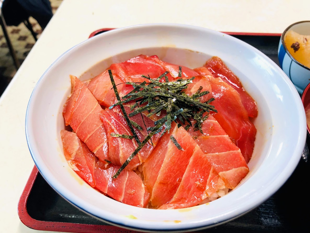
Also, we recommend a seafood restaurant with a delicious seafood specialties called “Marayoshi Restaurant”.
Lunch set menu (Tuna with Tuna Bowll) 1200JPY
Miyagawa-chō Bus Stop is a few meters to the left following the crossroad where you climbed the slope that continues from this restaurant.
It is not frequent on buses, it is about one in one hour.
If you have too much time on your hands I recommend walking to Sakae-cho Bus Stop.
It is about 15 minutes on foot to Sakae-cho Bus Stop.
Do you need a guide for this hiking course?
If you are looking for guide of this hiking course, please refer to the following.